Penybontfawr: Difference between revisions
Jump to navigation
Jump to search
Created page with "{{Infobox town |name=Penybontfawr |county=Montgomeryshire |picture=The Railway Inn, Penybontfawr, Montgomeryshire.jpg |picture caption=The Railway Inn, Penybontfawr |os grid r..." |
mNo edit summary |
||
| Line 2: | Line 2: | ||
|name=Penybontfawr | |name=Penybontfawr | ||
|county=Montgomeryshire | |county=Montgomeryshire | ||
|picture=The Railway Inn, Penybontfawr | |picture=The Railway Inn, Penybontfawr - geograph.org.uk - 553116.jpg | ||
|picture caption=The Railway Inn, Penybontfawr | |picture caption=The Railway Inn, Penybontfawr | ||
|os grid ref=SJ085245 | |os grid ref=SJ085245 | ||
Latest revision as of 23:04, 2 September 2016
| Penybontfawr | |
| Montgomeryshire | |
|---|---|
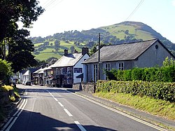
 The Railway Inn, Penybontfawr | |
| Location | |
| Grid reference: | SJ085245 |
| Location: | 52°48’40"N, 3°21’27"W |
| Data | |
| Postcode: | SY10 |
| Local Government | |
| Council: | Powys |
| Parliamentary constituency: |
Montgomeryshire |
Penybontfawr is a small village in Montgomeryshire, on the River Tanat, where the B4391 following down the Tanat Valley is met by the B4396 coming down Cwm Hirnant.
The local pub is the Railway Inn, although there is no railway here. It was formerly though on the Tanat Valley Light Railway, and the village grew up in the nineteenth century as a result of the transport links - the railway and the junction of valley roads.

This Montgomeryshire article is a stub: help to improve Wikishire by building it up.