Monnow Bridge: Difference between revisions
Created page with "{{county|Monmouthshire}} thumb|right|300px|The Monnow Bridge The '''Monnow Bridge''' in Monmouth is the only remaining mediæva..." |
|||
| Line 34: | Line 34: | ||
File:Monnow Bridge & Gatehouse - 1915.jpg|Monnow Bridge and Gatehouse, 1915 | File:Monnow Bridge & Gatehouse - 1915.jpg|Monnow Bridge and Gatehouse, 1915 | ||
File:Monnow Bridge (5).jpg|5 July 1918: Tank 'Julian' as part of the War Savings campaign the tank arrived by train at Monmouth Troy railway station and was led in procession to Agincourt Square | File:Monnow Bridge (5).jpg|5 July 1918: Tank 'Julian' as part of the War Savings campaign the tank arrived by train at Monmouth Troy railway station and was led in procession to Agincourt Square | ||
File:Monnow Bridge | File:Farmers' market on Monnow Bridge - geograph.org.uk - 670778.jpg|Farmers' market on Monnow Bridge | ||
An old Gateway at Monmouth (3375361).jpg|Lithograph by Thomas Christopher Hofland, 1825 | An old Gateway at Monmouth (3375361).jpg|Lithograph by Thomas Christopher Hofland, 1825 | ||
</gallery> | </gallery> | ||
Latest revision as of 23:29, 18 December 2015

The Monnow Bridge in Monmouth is the only remaining mediæval fortified river bridge in Great Britain with its gate tower still standing in place. It crosses the River Monnow some 500yds above its confluence with the River Wye. Now pedestrianised, it is a Scheduled Monument and a Grade I listed building.
13th- and 14th-century bridge and gatehouse


The existing bridge was completed in the late 13th century, traditionally in 1272 though this date has no supporting documentary evidence.[1] It replaced an earlier wooden structure. Work on flood defences in 1988 revealed remains of a wooden bridge directly under the existing one, and dendrochronological analysis indicated that its timber came from trees felled between 1123 and 1169.[2] Some sources suggest that the bridge and the nearby Church of St Thomas the Martyr were damaged by fire in the Battle of Monmouth, between supporters of Henry III and the forces of Richard Marshal, Earl of Pembroke, in 1233.[3]
The stone bridge is constructed of Old Red Sandstone, with three arches on hexagonal piers forming pointed cutwaters. The gatehouse, called Monnow Gate, which gives Monnow Bridge its remarkable and noteworthy appearance, was added at the end of the 13th or start of the 14th century, a few years after the bridge itself was built. In 1297 Edward I provided a murage grant in favour of Monmouth, in response to a request from his nephew Henry of Lancaster. This permitted and enabled the townspeople to build the town walls and gates for defence and protection. By 1315, this work was still incomplete or was in need of repair, since the original authority was renewed on 1 June 1315. At that time, the bridge would have been much narrower than now, with all traffic passing beneath a portcullis – the grooves for the lowering of which are still visible[1] – and through a single arch. The prominent arched machicolations were added at an unknown date in the mediæval period, possibly in the late 14th century.[2]
According to local historian Keith Kissack, the gate house was ineffective in defensive terms, as the Monnow could easily be crossed on foot just upstream.[4] However, as well as providing some defence for the Anglo-Norman population of the town against attacks by the Welsh of the surrounding areas, it served as a barrier to collect tolls from those attending markets. Tolls were authorised in the Patent Rolls of 1297 and 1315, and in subsequent town charters.[2]
Later activities and works
Neither Monmouth town nor its castle were attacked in the rebellion of Owain Glyndŵr, although nearby Abergavenny and Grosmont were burned down in the uprising, and the town suffered from the devastation in surrounding areas. Over two centuries later, in the Civil War, the town changed hands several times, and in 1645 the bridge was the scene of a skirmish between Royalist soldiers from Raglan and Parliamentarians under Colonel Kirle. By 1705 the gate needed maintenance. The original battlements were replaced with solid walls, and the building was refitted to form a two-storey dwelling house, with timber and lath extensions projecting over the river. The house was then leased to a resident gatekeeper, responsible for repairing and maintaining the building. Part of it remained in use as a lock-up, and both the bridge and the gatehouse were comprehensively repaired between 1771–75. The gatehouse was abandoned as a dwelling before 1804.[2]
The lean-to extensions were in turn demolished in 1815, and in 1819 a pedestrian passageway was driven through the building on the upstream side, to help relieve the flows of traffic across the bridge. Before 1830, the gatehouse was owned by Monmouth Corporation, but was then formally transferred to the Duke of Beaufort as part of a property exchange. The gatehouse roof was reconstructed in 1832, with deeper eaves and four decorative corbels on each side. A second passageway was added on the downstream side of the arch in 1845. Since then, the structure has remained essentially unchanged, through regular maintenance and repair.[1][2][5] Its ownership was transferred to the County Council in 1900, as noted on a brass plaque attached to the gatehouse.[2]
Until the mid 19th century, the gatehouse was the scene of annual battles, or "muntlings", between rival gangs from "Up-Town" – the main town of Monmouth – and Overmonnow or "Cappers' Town", so called because it was the traditional home of those who made Monmouth caps. These took place on 1 and 29 May, the youths arming themselves with besoms or "muntles" reinforced with stones. The altercations were banned in 1858.[6][7]
Into the 20th century


From 1889 to 1902 an extensive programme of |conservation was carried out on the bridge, this began with the prevention of the potential collapse of the tower by inserting metal rods to tie the two faces of the tower together, the four round plates of the at the ends of these two rods can still be seen. In 1892, work began on the arches and piers of the bridge as it was discovered that riverbed erosion had seriously undermined the piers. This period of conservation was ended with maintenance being carried out on the gate tower exterior from the mid-1890s to 1897. Roof guttering and downpipes were added, badly eroded stone was replaced with squared blocks of old red sandstone and the cruciform arrow slit on the front, left, of the tower was restored to make it symmetrical. In April 1893, the bridge's first street lamp was erected by the town council. In the late 1920s the top portion was replaced with twin electric lamps. In the 1960s the lamp was removed completely and since 1991 the bridge has been floodlit[2]
In the 20th century the growth of traffic using the road, with resulting accidents and congestion on what was a humpback bridge with poor visibility and narrow approach roads, led to many proposals to by-pass the bridge. The structure was first formally recognised as an Ancient Monument in 1923, and proposals for a new road bridge began to be made about the same time.[2] The new A40 road, built in 1965/66 relieved the town of much through traffic, and a town centre plan prepared by the District Council in 1981 proposed a new bridge. A serious accident on 18 May 1982, when a double decker bus attempted to cross into Monmouth, closed the bridge for a month while major repairs were performed.[2]
A feasibility study was made in 1999 by engineers Ove Arup and Partners for a bridge further along from the Monnow bridge, but the scheme came to nothing.[8] However, a new road bridge over the Monnow, for local traffic within the town, was eventually built and opened on 15 March 2004, allowing the old bridge to become pedestrianised. The project also meant the demolition of the old cattle market. To commemorate the Millennium, a ceramic mosaic was installed by Monmouth Town Council. The circular plinth is made of 40 tiles that illustrate over 2,000 years of local history.[9] The image of the bridge is recognised as an icon representing the town (see image from "The Interactives" magazine).[10]
Gallery
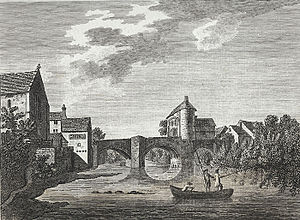
-
The Monnow Bridge, engraving of a pencil and wash, Thomas Hearne, 1780s
-
Monnow Bridge and Gatehouse, 1915
-
5 July 1918: Tank 'Julian' as part of the War Savings campaign the tank arrived by train at Monmouth Troy railway station and was led in procession to Agincourt Square
-
Farmers' market on Monnow Bridge
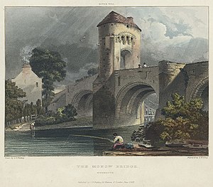
-
Lithograph by Thomas Christopher Hofland, 1825
References
- ↑ 1.0 1.1 1.2 Newman, John (2000). The Buildings of Wales: Gwent/Monmouthshire. Penguin Books. p. 402. ISBN 0-14-071053-1.
- ↑ 2.0 2.1 2.2 2.3 2.4 2.5 2.6 2.7 2.8 Rowlands, M.L.J. (1994). Monnow Bridge and Gate. Alan Sutton Publishing. ISBN 0-7509-0415-1.
- ↑ "History of St Thomas the Martyr". Monmouth Parishes. http://www.monmouthparishes.org/index.php?page=History-of-St-Thomas-the-Martyr. Retrieved 9 December 2011.
- ↑ "Monnow Bridge". The Monmouth Website. http://www.monmouth.org.uk/index.php/local/history/places-of-interest2/35-monnow-bridge.html. Retrieved 1 April 2012.
- ↑ Monmouth Civic Society (n.d.). Guide to the Monmouth Heritage Blue Plaque Trail. p. 4.
- ↑ Palmer, Roy (1998). The Folklore of (Old) Monmouthshire. Logaston Press. p. 262. ISBN 1-873827-40-7.
- ↑ Greene, William Henry. Jack o' Kent and the Devil: stories of a Welsh border hero. p. 5. https://listserv.heanet.ie/cgi-bin/wa?A3=ind1003&L=CELTIC-L&E=quoted-printable&P=371303&B=--_d41d383d-8b1d-44d1-9ef0-10cb89f4381f_&T=text%2Fhtml;%20charset=Windows-1252. Retrieved 3 April 2012.
- ↑ Wayne Forster and Ove Arup and Partners – New Bridge at Monmouth, Report to Monmouthshire County Council on feasibility and urban impact of new bridge in Monmouth with Ove Arup and Partners, University of Wales Cardiff (1999)
- ↑ "Monmouth Town Guide" (PDF). Monmouth Town Council. December 2011. p. 8. http://www.visitwyevalley.com/download/downloads/id/67/monmouth_town_guide_20112012. Retrieved 3 April 2012.
- ↑ Sacks, Jason. "Peter Rogers: Faith in British Imagination". http://www.comicsbulletin.com/main/interviews/peter-rogers-faith-british-imagination. Retrieved 7 March 2012.
Further reading
- Jervoise, Edwyn (1936). The Ancient Bridges of Wales and Western England. IV. Westminster: The Architectural Press for the Society for the Protection of Ancient Buildings. pp. 123–124.
Outside links
| ("Wikimedia Commons" has material about Bridge Monnow Bridge) |
- Wikishire map: 51°48’32"N, 2°43’12"W
- Geograph photos of Monnow Bridge


