Llanferres: Difference between revisions
No edit summary |
|||
| Line 20: | Line 20: | ||
It is located 755 ft above sea level in the upper valley of the [[River Alyn]] on the A494 road between [[Ruthin]] and [[Mold]].<ref>Ordnance Survey 1:25,000 Explorer Map, ''Clwydian Range''</ref> | It is located 755 ft above sea level in the upper valley of the [[River Alyn]] on the A494 road between [[Ruthin]] and [[Mold]].<ref>Ordnance Survey 1:25,000 Explorer Map, ''Clwydian Range''</ref> | ||
The village lies on the eastern slopes of the [[Clwydian Range|Clwydian Hills]], just south of Moel Famau, and is wholly within the Clwydian Range Area of Outstanding Natural Beauty.<ref>{{citation|url=http://www.clwydianrangeaonb.org.uk/text01.asp?PageId=29 |title=AONB Designation|publisher=Clwydian Range AONB|accessdate=9 January 2008}}</ref> [[Offa's Dyke Path]] passes one mile to the southwest of the village. The parish of Llanferres area includes the village of Maeshafn and hamlets of Tafarn-y-Gelyn and [[Loggerheads]]. | The village lies on the eastern slopes of the [[Clwydian Range|Clwydian Hills]], just south of Moel Famau, and is wholly within the Clwydian Range Area of Outstanding Natural Beauty.<ref>{{citation|url=http://www.clwydianrangeaonb.org.uk/text01.asp?PageId=29 |title=AONB Designation|publisher=Clwydian Range AONB|accessdate=9 January 2008}}</ref> [[Offa's Dyke Path]] passes one mile to the southwest of the village. The parish of Llanferres area includes the village of Maeshafn and hamlets of Tafarn-y-Gelyn and [[Loggerheads, Denbighshire|Loggerheads]]. | ||
== Notable landmarks == | == Notable landmarks == | ||
Latest revision as of 13:50, 10 November 2014
| Llanferres | |
| Denbighshire | |
|---|---|

| |
| Location | |
| Grid reference: | SJ188604 |
| Location: | 53°8’13"N, 3°12’50"W |
| Data | |
| Population: | 676 (2001) |
| Post town: | Mold |
| Postcode: | CH7 |
| Dialling code: | 01352 |
| Local Government | |
| Council: | Denbighshire |
| Parliamentary constituency: |
Clwyd West |
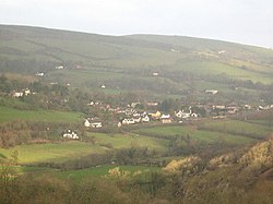
Llanferres is a village and parish in Denbighshire. At the 2001 Census the population of the parish was recorded as 676.[1]
Geography
It is located 755 ft above sea level in the upper valley of the River Alyn on the A494 road between Ruthin and Mold.[2]
The village lies on the eastern slopes of the Clwydian Hills, just south of Moel Famau, and is wholly within the Clwydian Range Area of Outstanding Natural Beauty.[3] Offa's Dyke Path passes one mile to the southwest of the village. The parish of Llanferres area includes the village of Maeshafn and hamlets of Tafarn-y-Gelyn and Loggerheads.
Notable landmarks
The parish church, which is dedicated to St. Berres, was mentioned in the 'Lincoln Taxation' of 1291. It was largely rebuilt in 1774/1775, with additions in 1843. There were further additions, and a major restoration, in 1892.
Originally mediæval, a now mainly Georgian and Victorian church with a jolly ‘lantern’ bellcote. The Church, adjacent Druid Inn and farm (private), form a pleasing group. A visit will be enhanced by the guide pamphlet available in the Church. [4]
Saint Berres, (with variations such as Brice or Britius) was a 4th-century to 5th-century Welsh hermit, who according to Thomas Pennant was a disciple of St Martin of Tours, the Hungarian.
References
- ↑ 2001 Census: Llanferres, Office for National Statistics, http://neighbourhood.statistics.gov.uk/dissemination/LeadTableView.do?a=3&b=801630&c=llanferres&d=16&e=15&g=414070&i=1001x1003x1004&m=0&r=1&s=1224437379898&enc=1&dsFamilyId=779, retrieved 19 October 2008
- ↑ Ordnance Survey 1:25,000 Explorer Map, Clwydian Range
- ↑ AONB Designation, Clwydian Range AONB, http://www.clwydianrangeaonb.org.uk/text01.asp?PageId=29, retrieved 9 January 2008
- ↑ Dr Charles Kightly. Enjoy Medieval Denbighshire. Denbighshire County Council.