Painswick: Difference between revisions
No edit summary |
m clean up, typos fixed: Consequently → Consequently, |
||
| Line 24: | Line 24: | ||
There is evidence of settlement in the area as long ago as the Iron Age, which can be seen in the defensive earthworks atop nearby Painswick Beacon, which has wide views across the [[River Severn|Severn Vale]]. The local monastery, Prinknash Abbey, was established as long ago as the 11th century. | There is evidence of settlement in the area as long ago as the Iron Age, which can be seen in the defensive earthworks atop nearby Painswick Beacon, which has wide views across the [[River Severn|Severn Vale]]. The local monastery, Prinknash Abbey, was established as long ago as the 11th century. | ||
During the first Civil War (1642–1645) [[Gloucester]] was a Parliamentarian stronghold of some strategic importance. Consequently it was surrounded by forces loyal to the King. After the siege of Gloucester was broken on 5 September 1643, the Royalist army, which had been surrounding the city, encamped overnight at Painswick. Some damage was caused by the troops and a scar from two small cannonballs can still be seen on the tower of St. Mary's parish church. | During the first Civil War (1642–1645) [[Gloucester]] was a Parliamentarian stronghold of some strategic importance. Consequently, it was surrounded by forces loyal to the King. After the siege of Gloucester was broken on 5 September 1643, the Royalist army, which had been surrounding the city, encamped overnight at Painswick. Some damage was caused by the troops and a scar from two small cannonballs can still be seen on the tower of St. Mary's parish church. | ||
==Parish Church== | ==Parish Church== | ||
| Line 69: | Line 69: | ||
*[http://www.croft.gloucs.sch.uk/ The Croft school] | *[http://www.croft.gloucs.sch.uk/ The Croft school] | ||
*{{geograph|3731152|Painswick}} | *{{geograph|3731152|Painswick}} | ||
*[http://www.bbc.co.uk/gloucestershire/content/articles/2008/08/28/dayout_painswick_feature.shtml BBC archive film of Painswick | *[http://www.bbc.co.uk/gloucestershire/content/articles/2008/08/28/dayout_painswick_feature.shtml BBC archive film of Painswick] | ||
==References== | ==References== | ||
{{reflist}} | {{reflist}} | ||
Revision as of 17:25, 27 January 2016
| Painswick | |
| Gloucestershire | |
|---|---|
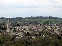
 Painswick from Longridge | |
| Location | |
| Grid reference: | SO866098 |
| Location: | 51°47’15"N, 2°11’41"W |
| Data | |
| Population: | 2,070 (2001) |
| Post town: | Stroud |
| Postcode: | GL6 |
| Dialling code: | 01452 |
| Local Government | |
| Council: | Stroud |
| Parliamentary constituency: |
Stroud |
Painswick is a village in Gloucestershire, one of the many which once waxed rich on the wool trade, but it is now best known for its parish church's yew trees and the local Rococo Garden. The village is mainly constructed of locally quarried Cotswold stone. Many of the buildings feature south-facing attic rooms once used as weavers' workshops.
Painswick stands on a hill overlooking the Stroud Valleys. Its narrow streets and traditional architecture make it the epitome of the English village.
There is a golf course near Painswick Beacon.
History
There is evidence of settlement in the area as long ago as the Iron Age, which can be seen in the defensive earthworks atop nearby Painswick Beacon, which has wide views across the Severn Vale. The local monastery, Prinknash Abbey, was established as long ago as the 11th century.
During the first Civil War (1642–1645) Gloucester was a Parliamentarian stronghold of some strategic importance. Consequently, it was surrounded by forces loyal to the King. After the siege of Gloucester was broken on 5 September 1643, the Royalist army, which had been surrounding the city, encamped overnight at Painswick. Some damage was caused by the troops and a scar from two small cannonballs can still be seen on the tower of St. Mary's parish church.
Parish Church

The parish church of St Mary is a Grade I listed building.[1] A priest in Painswick is noted in the Domesday Book and so it is assumed that there was also a church here at that time. Evidence suggests that it was built between 1042 and 1066 by Ernesi, an Anglo Saxon thegn who was then Lord of the Manor.
After the Norman conquest the Lordship passed to the family of de Laci, the patron saint of which was St Peter. In 1377 the chapel at the north side of the church was rebuilt and dedicated to St. Peter. This is the oldest part of the church. Shortly afterwards the north aisle was added. By this time the de Laci family had given the living to the Prior and Canons of Llanthony Priory who had spiritual oversight of the parish until the Reformation.
The nave and tower were built about 1480 and by 1550 the sanctuary has taken its present form. The spire was not added until 1632. The church remained in this form until the Civil War when it was occupied by Parliamentarians in 1644. The Royalists recaptured the village, however, after severe fighting. Bullet and cannon shot marks remain on the church tower to this day. The church was greatly damaged by fire.
In 1657 a gallery was added to the north aisle. In 1740 the south aisle was built with a gallery above. A west gallery was added in 1840. In 1877 the church was restored by public subscription. The font dates from 1661 and replaced one destroyed during the Civil War. The Royal arms over the entrance door are those of William IV.

The imposing tomb was occupied by three different families and suffered in the fire of 1644. The First World War screen was carved by a Belgian refugee and lists all those from Painswick who served and the names of those who died in gold.
The organ was originally built in the 18th century by Sneltzer but only the casing remains. The present instrument was installed by Nicholson of Worcester.
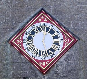
A bell ringers' society was formed in 1686 and the ringers are still known as the "Ancient Society of Painswick Youths". Before 1731 there were eight bells, but the ring was augmented in 1732 and in 1819 by four further bells. In 1986 to celebrate the tercentenary of the society a thirteenth bell was added and the clock face restored. In 1993 the addition of an extra treble bell, made possible by a generous donation, completed the present ring of fourteen bells.
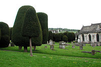
In the churchyard Painswick has a unique collection of chest tombs and monuments from the early 17th century onwards, carved in local stone by local craftsmen. The oldest tomb, with fossils on the top, is of William Loveday, Yeoman, dated 1623.[2] Clifton-Taylor describes the churchyard, with its tombs and yews, as "the grandest churchyard in England".[3]
Other churches and chapels
- Church of England: St Mary (above)
- Ebenezer Chapel: formerly Primitive Methodist, in Bisley Street, built in 1854
- Quakers: Friends' Meeting House on Vicarage Street, built in 1705/6, refurbished in 1793/4 and closed in 1894. It re-opened in 1952.
- United Reformed Church in Gloucester Street, built as a Congregational chapel in 1803. It was extensively altered in 1892 and renamed "The Cornelius Winter Memorial Chapel".[4]
- Roman Catholic: The Chapel of Our Lady and St Teresa, on Friday Street. It opened in 1934: the building had previously been a slaughter house. On 15 June 1941 it was almost completely destroyed by a German bomb but was restored and re-opened in 1956.
The Baptist Chapel was built on New Street in 1806 by the Wesleyan Methodists, but was sold to the Baptists in 1831. The premises are now used by an estate agent.
Local traditions

On the nearest Sunday to 19 September the ceremony known as "clipping the church" takes place. Local children wear flowers in their hair, join hands and embrace St. Mary's parish church.
Folklore holds that the churchyard will never have more than 99 yew trees and that should a 100th grow the Devil would pull it out.[5] According to the Victoria and Albert Museum a count of the trees showed there to be 103.[6] The plan of the churchyard included in the church's own public leaflet shows 100.[7]
While Royalists were encamped in Painswick, tradition has it that King Charles went up to the Beacon and, seeing the beautiful valley to the east said "This must be Paradise". Since then that valley, and the hamlet on its western side to the north of Painswick have been called Paradise.
During the 18th century a group of gentry, led by Benjamin Hyett, organised an annual procession dedicated to Pan, during which a statue of the deity was held aloft, and people shouted 'Highgates! Highgates!". The tradition died out in the 1830s, but was revived in 1885 by the new vicar, W H Seddon, who mistakenly believed that the festival had been ancient in origin. Seddon's successor, however, was less appreciative of the pagan festival and put an end to it in 1950, when he had Pan's statue buried.[8]
Outside links
- Painswick Parish Council
- Painswick Beacon Community Newspaper
- The Adey family history From approximately 1650 in Painswick to the present day.
- The Croft school
- Pictures of Painswick and the area on Geograph.co.uk
- BBC archive film of Painswick
References
- ↑ Images of England — details from listed building database (133370) Church of St Mary, Painswick
- ↑ St. Mary's Painswick, Church leaflet, obtained July 2008
- ↑ Clifton-Taylor, Alec (1974). English Parish Churches as Work of Art. London: Batsford. pp. 37–38. ISBN 0-7134-2776-0.
- ↑ GlosGen Painswick and Neighbourhood
- ↑ "Painswick". Stroud News and Journal. http://www.stroudnewsandjournal.co.uk/information/villageguides/display.var.745743.0.painswick.php. Retrieved 2007-05-03.
- ↑ "The famed clipped yew trees of Painswick Churchyard. Gloucestershire. 1902". The Victoria and Albert Museum. http://www.vam.ac.uk/content/articles/s/sir-benjamin-stone-and-the-NPRA/. Retrieved 2007-05-03.
- ↑ St. Mary's Painswick, A Stroll Around the Churchyard, Church leaflet, obtained July 2008
- ↑ The Triumph of the Moon: A History of Modern Pagan Witchcraft, Ronald Hutton, page 161-162