Buchan: Difference between revisions
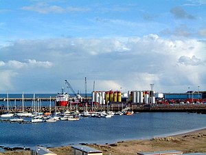
Created page with 'right|thumb|300px|Peterhead Bay '''Buchan''' is a traditional district of Aberdeenshire, occupying the "Cold Shoulder of…' |
|||
| Line 17: | Line 17: | ||
==Outside links== | ==Outside links== | ||
*[http://www.visitpeterhead.com Official Tourism Site for Buchan] | *[http://www.visitpeterhead.com Official Tourism Site for Buchan] | ||
*[ | *[https://maps.nls.uk/view/74417584 1714 map showing Buchan] | ||
==References== | ==References== | ||
Latest revision as of 16:53, 8 June 2019

Buchan is a traditional district of Aberdeenshire, occupying the "Cold Shoulder of Scotland", where the land juts in a broad corner into the North Sea, the Moray coast to the west.
This area is also an historic earldom, and Buchan appears as such on early maps. The Earldom of Mar and Buchan formed one of the seven original Scottish earldoms; later the Earl of Buchan became separated from Mar.
The largest town in Buchan is Peterhead, which is indeed the largest town in the county apart from Aberdeen and the principal white fish landing port in Europe; and a major oil industry service centre. Equally important is the nearby gas terminal at St Fergus. RAF Buchan, a radar station, is in the area.
Attempts are being made to counter the negative effects of several recent key company closures and economic threats. Inland, the area is dependent upon agriculture, and many villages have seen a decline in population and services.
The Formartine and Buchan Way runs through Buchan.
History
Buchan was part of the Pictish kingdom of Ce.
There is considerable ancient history in this geographic area, especially slightly northwest of Cruden Bay, where the Catto Long Barrow and numerous tumuli are found.[1]
Outside links
References
- ↑ C. Michael Hogan. 2008. Catto Long Barrow fieldnotes, The Modern Antiquarian