Jordanstown: Difference between revisions
Created page with '{{Infobox town |name=Jordanstown |county=Antrim |picture= |picture caption= |os grid ref=J3584 |LG district=Newtownabbey }} '''Jordanstown''' is a village in County Antrim. …' |
No edit summary |
||
| Line 1: | Line 1: | ||
{{Infobox town | {{Infobox town | ||
|name=Jordanstown | |name=Jordanstown | ||
|county=Antrim | |county=Antrim | ||
|picture= | |picture=Loughshore Park, Jordanstown. N.Ireland - panoramio.jpg | ||
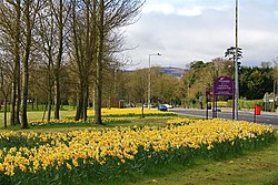
|picture caption= | |picture caption= Loughshore Park, Jordanstown | ||
|os grid ref= | |os grid ref=J362833 | ||
|LG district=Newtownabbey | |latitude=54.67991 | ||
|longitude=-5.888672 | |||
|os grid ref= | |||
|population=5,494 | |||
|census year=2001 | |||
|post town=Newtownabbey | |||
|postcode=BT37 | |||
|dialling code=028 | |||
|LG district=Antrim and Newtownabbey | |||
|constituency=East Antrim | |||
|townland=yes | |||
}} | }} | ||
'''Jordanstown''' is a | '''Jordanstown''' is village (and a townland (of 964 acres) on the north shore of [[Belfast Lough]], in [[County Antrim]]. It is within the urban area of [[Newtownabbey]]. | ||
{{ | The village t had a population of 5,494 at the 2001 census. | ||
Jordanstown includes a [[University of Ulster]] campus, a bowling club, a few schools and shops. It | |||
also has a beach and seafront park area called Loughshore Park, which hosts various events throughout the year including the three-day Loughshore Festival over the last weekend in August. The park sits on the shore of [[Belfast Lough]]. | |||
Jordanstown has been voted fifth most attractive place to live in Northern Ireland by the Neighbourhood Information Service. | |||
[[File:The Shore Road, Jordanstown - geograph.org.uk - 722901.jpg|left|thumb|200px|Shore Road in Jordanstown]] | |||
==Name== | |||
The place is named from an Anglo-Norman family called Jordan who accompanied John de Courcy to Carrickfergus in 1182.<ref>{{placenamesNI|6456}}</ref> | |||
==Churches== | |||
*[http://jordanstown.connor.anglican.org/ St. Patrick's Church] (Church of Ireland) | |||
*[http://www.whiteabbey.org/ Whiteabbey Presbyterian Church] | |||
==History== | |||
Jordanstown was a semi-rural district until the 1950s when it expanded rapidly with the construction of new housing. Middle-class families were attracted to the area due to its location adjacent to Belfast Lough and the railway station, which provides access to Belfast City Centre. | |||
==Transport links== | |||
The Shore Road runs through Jordanstown, alongside the shore of the Lough from Belfast to the Antrim coast | |||
Jordanstown railway station was opened on February 1, 1853.<ref>{{cite web | title=Jordanstown station | work=Railscot - Irish Railways | url=http://www.railscot.co.uk/Ireland/Irish_railways.pdf | accessdate=2007-08-28}}</ref> | |||
{{Commons}} | |||
==References== | |||
{{reflist}} | |||
Revision as of 22:50, 13 November 2017
| Jordanstown | |
| County Antrim | |
|---|---|
 Loughshore Park, Jordanstown | |
| Location | |
| Location: | 54°40’48"N, 5°53’19"W |
| Data | |
| Population: | 5,494 (2001) |
| Post town: | Newtownabbey |
| Postcode: | BT37 |
| Dialling code: | 028 |
| Local Government | |
| Council: | Antrim and Newtownabbey |
| Parliamentary constituency: |
East Antrim |
Jordanstown is village (and a townland (of 964 acres) on the north shore of Belfast Lough, in County Antrim. It is within the urban area of Newtownabbey.
The village t had a population of 5,494 at the 2001 census.
Jordanstown includes a University of Ulster campus, a bowling club, a few schools and shops. It also has a beach and seafront park area called Loughshore Park, which hosts various events throughout the year including the three-day Loughshore Festival over the last weekend in August. The park sits on the shore of Belfast Lough.
Jordanstown has been voted fifth most attractive place to live in Northern Ireland by the Neighbourhood Information Service.

Name
The place is named from an Anglo-Norman family called Jordan who accompanied John de Courcy to Carrickfergus in 1182.[1]
Churches
- St. Patrick's Church (Church of Ireland)
- Whiteabbey Presbyterian Church
History
Jordanstown was a semi-rural district until the 1950s when it expanded rapidly with the construction of new housing. Middle-class families were attracted to the area due to its location adjacent to Belfast Lough and the railway station, which provides access to Belfast City Centre.
Transport links
The Shore Road runs through Jordanstown, alongside the shore of the Lough from Belfast to the Antrim coast
Jordanstown railway station was opened on February 1, 1853.[2]
| ("Wikimedia Commons" has material about Jordanstown) |
References
- ↑ Jordanstown - Placenames NI
- ↑ "Jordanstown station". Railscot - Irish Railways. http://www.railscot.co.uk/Ireland/Irish_railways.pdf. Retrieved 2007-08-28.
