Moel y Gest: Difference between revisions
Jump to navigation
Jump to search
Created page with '{{Infobox hill |name=Moel-y-Gest |county=Caernarfonshire |picture=Moel y Gest - geograph.org.uk - 45653.jpg |picture caption=Moel y Gest |os grid ref=SH552390 |height=863 feet }}…' |
No edit summary |
||
| Line 5: | Line 5: | ||
|picture caption=Moel y Gest | |picture caption=Moel y Gest | ||
|os grid ref=SH552390 | |os grid ref=SH552390 | ||
|latitude=52.928825 | |||
|longitude=-4.155619 | |||
|height=863 feet | |height=863 feet | ||
}} | }} | ||
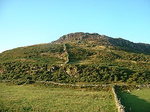
'''Moel y Gest''' is a modest, craggy-topped hill against whose flank the town of [[Porthmadog]] nestles, in [[Caernarfonshire]] at the root of the [[Lleyn]] peninsula. It rises to 863 feet and is topped with a trig pillar. | '''Moel y Gest''' is a modest, craggy-topped hill against whose flank the town of [[Porthmadog]] nestles, in [[Caernarfonshire]] at the root of the [[Lleyn]] peninsula. It rises to 863 feet and is topped with a trig pillar. | ||
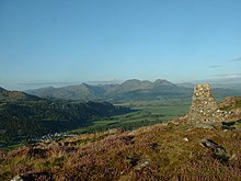
The summit overlooks Porthmadog and Tremadoc Bay, down to the village of [[Borth-y-Gest]], with the [[River Glaslyn]] and [[Traeth Bach]] laid out before its feet | The summit overlooks Porthmadog and Tremadoc Bay, down to the village of [[Borth-y-Gest]], with the [[River Glaslyn]] and [[Traeth Bach]] laid out before its feet. | ||
[[File:Moel y Gest Summit - geograph.org.uk - 45649.jpg|left|220px|Moel-y-Gest summit]] | [[File:Moel y Gest Summit - geograph.org.uk - 45649.jpg|thumb|left|220px|Moel-y-Gest summit]] | ||
{{stub}} | {{stub}} | ||
Latest revision as of 13:57, 24 October 2017
| Moel-y-Gest | |
| Caernarfonshire | |
|---|---|
 Moel y Gest | |
| Summit: | 863 feet SH552390 52°55’44"N, 4°9’20"W |
Moel y Gest is a modest, craggy-topped hill against whose flank the town of Porthmadog nestles, in Caernarfonshire at the root of the Lleyn peninsula. It rises to 863 feet and is topped with a trig pillar.
The summit overlooks Porthmadog and Tremadoc Bay, down to the village of Borth-y-Gest, with the River Glaslyn and Traeth Bach laid out before its feet.

This Mountain or hill article is a stub: help to improve Wikishire by building it up.