Charlemont, County Armagh: Difference between revisions
Jump to navigation
Jump to search
Created page with '{{Infobox town |name=Charlemont |county=Armagh |picture= |picture caption= |os grid ref=H8555 |LG district=Armagh }} '''Charlemont''' is a village in County Armagh. {{stub}}' |
No edit summary |
||
| Line 2: | Line 2: | ||
|name=Charlemont | |name=Charlemont | ||
|county=Armagh | |county=Armagh | ||
|picture= | |picture=Bridge over the River Blackwater at Charlemont - geograph.org.uk - 531618.jpg | ||
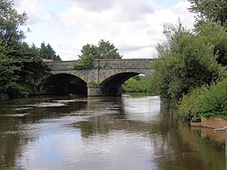
|picture caption= | |picture caption=Bridge over the River Blackwater at Charlemont | ||
|os grid ref=H8555 | |os grid ref=H8555 | ||
|latitude=54.443 | |||
|longitude=-6.690 | |||
|LG district=Armagh | |LG district=Armagh | ||
|post town=Dungannon | |||
|postcode=BT71 | |||
|townland=yes | |||
}} | }} | ||
'''Charlemont''' is a village in [[County Armagh]]. | The Borough of '''Charlemont''' is a village and [[townland]] in north-western [[County Armagh]] adjacent to the border with [[County Antrim]]. It is situated on the A29 road between [[Armagh]] and [[Dungannon]]. It had a population of 150 people in the 2001 Census. | ||
Charlemont Bridge joins the villages of Charlemont on the east bank of the [[River Blackwater, Ulster|River Blackwater]], which here forms the county border, and Moy on the west. | |||
{{stub}} | {{stub}} | ||
Revision as of 09:29, 11 November 2015
| Charlemont | |
| County Armagh | |
|---|---|
 Bridge over the River Blackwater at Charlemont | |
| Location | |
| Grid reference: | H8555 |
| Location: | 54°26’35"N, 6°41’24"W |
| Data | |
| Post town: | Dungannon |
| Postcode: | BT71 |
| Local Government | |
| Council: | Armagh, Banbridge and Craigavon |
The Borough of Charlemont is a village and townland in north-western County Armagh adjacent to the border with County Antrim. It is situated on the A29 road between Armagh and Dungannon. It had a population of 150 people in the 2001 Census.
Charlemont Bridge joins the villages of Charlemont on the east bank of the River Blackwater, which here forms the county border, and Moy on the west.

This County Armagh article is a stub: help to improve Wikishire by building it up.