Beragh: Difference between revisions
Created page with '{{Infobox town |name=Beragh |county=Tyrone |picture= |picture caption= |os grid ref=H5467 |LG district=Omagh }} '''Beragh''' is a village in Tyrone. {{stub}}' |
No edit summary |
||
| Line 2: | Line 2: | ||
|name=Beragh | |name=Beragh | ||
|county=Tyrone | |county=Tyrone | ||
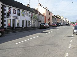
|picture= | |picture=Beragh County Tyrone - geograph.org.uk - 55621.jpg | ||
|picture caption= | |picture caption= | ||
|os grid ref= | |os grid ref=H544672 | ||
|LG district=Omagh | |latitude=54.55042 | ||
|longitude=-7.16031 | |||
|population=520 | |||
|census year=2001 | |||
|post town=Omagh | |||
|postcode=BT79 | |||
|dialling code=028 | |||
|townland=yes | |||
|LG district=Fermanagh and Omagh | |||
|constituency=West Tyrone | |||
}} | }} | ||
'''Beragh''' is a village in [[Tyrone]]. | '''Beragh''' is a village and townland in [[Tyrone]], found eight miles south-east of the county seat, [[Omagh]]. The 2001 Census recorded a population of 520. | ||
{{ | The name of the village is from the Gaelic ''Bearach'', meaning "place of points/hills/standing stones"<ref>{{placenamesNI|8360|Beragh}}</ref> It is in the Barony of [[Omagh East]]. | ||
==History== | |||
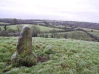
[[File:Standing stone at Beragh Hill - geograph.org.uk - 90673.jpg|right|thumb|200px|Standing stone in Beragh townland]] | |||
One of the first known references to the village was on a 1690 Plantation map of [[Ireland]]. In the 1820s this village, the property of Somerset Lowry-Corry, 2nd Earl Belmore, was described as having "one long wide street of very mean houses whose tenants for the most part appear to be poor". The inhabitants mostly worked in trade and agriculture. In 1841 the population was 617, the village having 103 houses. The village had a market patent granted under the name "Lowrystown". | |||
The Portadown, Dungannon and Omagh Junction Railway opened Beragh railway station on 2 September 1861. The Ulster Transport Authority closed the station and the PD&O line on 15 February 1965.<ref>{{cite web |title=Beragh station |work=Railscot - Irish Railways |url=http://www.railscot.co.uk/Ireland/Irish_railways.pdf |access-date=31 October 2011 |format=PDF}}</ref> | |||
==Sport== | |||
*Football: Beragh Swifts F.C. | |||
*Gaelic football: Beragh Red Knights | |||
==Outside links== | |||
{{commons}} | |||
==References== | |||
{{reflist}} | |||
Latest revision as of 22:45, 28 November 2022
| Beragh | |
| Tyrone | |
|---|---|

| |
| Location | |
| Grid reference: | H544672 |
| Location: | 54°33’2"N, 7°9’37"W |
| Data | |
| Population: | 520 (2001) |
| Post town: | Omagh |
| Postcode: | BT79 |
| Dialling code: | 028 |
| Local Government | |
| Council: | Fermanagh and Omagh |
| Parliamentary constituency: |
West Tyrone |
Beragh is a village and townland in Tyrone, found eight miles south-east of the county seat, Omagh. The 2001 Census recorded a population of 520.
The name of the village is from the Gaelic Bearach, meaning "place of points/hills/standing stones"[1] It is in the Barony of Omagh East.
History

One of the first known references to the village was on a 1690 Plantation map of Ireland. In the 1820s this village, the property of Somerset Lowry-Corry, 2nd Earl Belmore, was described as having "one long wide street of very mean houses whose tenants for the most part appear to be poor". The inhabitants mostly worked in trade and agriculture. In 1841 the population was 617, the village having 103 houses. The village had a market patent granted under the name "Lowrystown".
The Portadown, Dungannon and Omagh Junction Railway opened Beragh railway station on 2 September 1861. The Ulster Transport Authority closed the station and the PD&O line on 15 February 1965.[2]
Sport
- Football: Beragh Swifts F.C.
- Gaelic football: Beragh Red Knights
Outside links
| ("Wikimedia Commons" has material about Beragh) |
References
- ↑ Beragh - Placenames NI
- ↑ "Beragh station" (PDF). Railscot - Irish Railways. http://www.railscot.co.uk/Ireland/Irish_railways.pdf.
