Newport, Isle of Wight: Difference between revisions
Created page with '{{Infobox town | name= Newport | county=Hampshire | island=Isle of Wight | picture = Newport Quay.JPG | picture caption = Newport Quay | os grid ref= SZ502893 | latitude= 50.7010…' |
mNo edit summary |
||
| Line 20: | Line 20: | ||
Transportation connections by road link all major towns to Newport, making it the main shopping centre and location for public services on the island. Newport was also the hub of the island's rail system until 1966 when its station closed, the site now run through by the A3054 ''Medina Way'' dual carriageway. | Transportation connections by road link all major towns to Newport, making it the main shopping centre and location for public services on the island. Newport was also the hub of the island's rail system until 1966 when its station closed, the site now run through by the A3054 ''Medina Way'' dual carriageway. | ||
Transport by water has Newport as a centre too as River Medina, that great cleft through the Isle of Wight, runs through the middle of the town, and is still tidal and navigable as high as Newport, allowing ships to sail into the heart of the island. Above the town the river is a minor river. | |||
The nearest city to Newport is Portsmouth, some 13 miles north-east on the mainland. More locally, [[Ryde]], the island's largest town is located to the north-east, with other towns [[Sandown]] and [[Shanklin]] located to the east, and [[Cowes]] to the north. | The nearest city to Newport is Portsmouth, some 13 miles north-east on the mainland. More locally, [[Ryde]], the island's largest town is located to the north-east, with other towns [[Sandown]] and [[Shanklin]] located to the east, and [[Cowes]] to the north. | ||
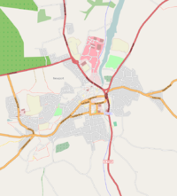
[[File:Newport map.png|right|thumb|200px|A map showing Newport.]] | [[File:Newport map.png|right|thumb|200px|A map showing Newport.]] | ||
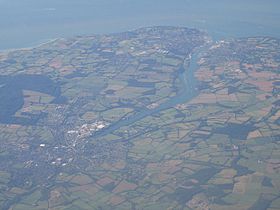
[[File:Newport-cowes.jpg|right|thumb|280px|An aerial photograph, showing Newport (bottom left).]] | [[File:Newport-cowes.jpg|right|thumb|280px|An aerial photograph, showing Newport (bottom left).]] | ||
Revision as of 22:34, 2 December 2010
| Newport | |
| Hampshire | |
|---|---|
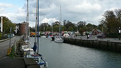 Newport Quay | |
| Location | |
| Island: | Isle of Wight |
| Grid reference: | SZ502893 |
| Location: | 50°42’4"N, 1°17’18"W |
| Data | |
| Population: | 23,957 |
| Post town: | Newport, isle of Wight |
| Postcode: | PO30 |
| Dialling code: | 01983 |
| Local Government | |
| Council: | Isle of Wight |
| Parliamentary constituency: |
Isle of Wight |
Newport is a town on the Isle of Wight, Hampshire. It is the island's principal town.
Newport is in the middle of the island, at the head of the navigable section of the River Medina, which flows northward to the Solent. The town has a quay on the river, giving direct access to the sea.
Transportation connections by road link all major towns to Newport, making it the main shopping centre and location for public services on the island. Newport was also the hub of the island's rail system until 1966 when its station closed, the site now run through by the A3054 Medina Way dual carriageway.
Transport by water has Newport as a centre too as River Medina, that great cleft through the Isle of Wight, runs through the middle of the town, and is still tidal and navigable as high as Newport, allowing ships to sail into the heart of the island. Above the town the river is a minor river.
The nearest city to Newport is Portsmouth, some 13 miles north-east on the mainland. More locally, Ryde, the island's largest town is located to the north-east, with other towns Sandown and Shanklin located to the east, and Cowes to the north.
Amenities
- Seaclose Park, on the east bank of the River Medina. It hosts the annual Isle of Wight Music Festival.
- The Postal Museum, possibly the largest private collection of vintage postal equipment and post boxes in the world.[1][2]
Prisons
The town's suburb of Parkhurst is home to three prison sites: the notorious Parkhurst Prison itself, Camp Hill, and Albany, all of which make up HMP Isle of Wight, the largest prison in the United Kingdom. Parkhurst and Albany were once amongst the few top-security prisons in the United Kingdom.
History
The Romans knew the Isle of Wight as Uectis, and there are signs of Roman settlement in the Newport area, including two known Roman villas one of which, Newport Roman Villa, is excavated and open to the public.[3]
After the Norman conquest, the town's first charter was granted late in the twelfth century. In 1377 an invading French force burnt down much of the town while attempting to take Carisbrooke Castle, then under the command of Sir Hugh Tyrill. A group of French were captured and killed, then buried in a tumulus later nicknamed Noddies Hill, a "noddy" being medieval slang for a body. This was later corrupted to Nodehill, the present-day name for a part of central Newport - a name confusing to many as the area is flat.[4]
The town was incorporated as a borough in 1608. The town's position as an area of trade accessible to the sea meant it rapidly took over from Carisbrooke as the main central settlement, eventually absorbing the latter as a suburb.
In recent times, Newport has undergone an influx of changes, with two shopping centres and all new road directions to show for the town's recent development efforts. Newport Quay has also been re-developed, with art galleries such as the Quay Arts Centre, and new flats converted from old warehouses.
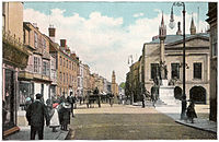
The Queen Victoria Memorial was designed by local architect, Percy Stone (1856–1934).[5]
Notes
- ↑ Postal Museum official website.
- ↑ Isle of Wight Postal Museum, WightCAM - photographically illustrated walks on the Isle of Wight.
- ↑ The villa on public display was found in 1926. Excavations at the site demonstrate that the villa was built around 280 AD. The villa featured underfloor heating, and elaborate hot and cold baths, sauna and massage rooms and a large kitchen
- ↑ BRANNON'S PICTURE OF THE ISLE OF WIGHT; Or The Expeditious Traveller's Index to Its Prominent Beauties & Objects of Interest. Compiled Especially with Reference to Those Numerous Visitors Who Can Spare but Two or Three Days to Make the Tour of the Island, Printed and Published by George Brannon, Wootton, Isle of Wight, 1843 (various sources give dates of 1844, 1848, 1849, etc, possibly of other editions)
- ↑ "Queen Victoria memorial". Memorials & Monuments on the Isle of Wight. 24 July 2009. http://www.isle-of-wight-memorials.org.uk/others/newportvictoria.htm. Retrieved 20 November 2009.