Hunstanworth: Difference between revisions
Jump to navigation
Jump to search
m Created page with '{{Infobox town |name=Hunstanworth |county=County Durham |os grid ref=NY949490 |latitude=54.835978 |longitude=-2.079759 |postcode=DH8 |LG district=Durham }} '''Hunstanworth''' is …' |
mNo edit summary |
||
| Line 2: | Line 2: | ||
|name=Hunstanworth | |name=Hunstanworth | ||
|county=County Durham | |county=County Durham | ||
|picture=Hunstanworth - geograph.org.uk - 536678.jpg | |||
|os grid ref=NY949490 | |os grid ref=NY949490 | ||
|latitude=54.835978 | |latitude=54.835978 | ||
Latest revision as of 21:48, 9 November 2012
| Hunstanworth | |
| County Durham | |
|---|---|

| |
| Location | |
| Grid reference: | NY949490 |
| Location: | 54°50’10"N, 2°4’47"W |
| Data | |
| Postcode: | DH8 |
| Local Government | |
| Council: | Durham |
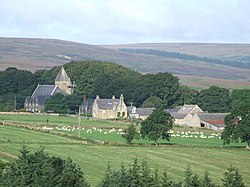
Hunstanworth is a small village in County Durham, found some 10 miles to the west of Consett, and southwest of the village of Blanchland.
The village was designed and built around the original 1781 parish church. The Reverend Daniel Capper commissioned architect Samuel Sanders Teulon to create the village in the 1860s, and Teulon delivered a vicarage and stable block, school and school-house and a mix of terraced, semi-detached and detached houses, all constructed of sandstone.
Hunstanworth is one of the Thankful Villages that suffered no fatalities during the Great War of 1914-1918, and the only such village in the county.
Outside links
| ("Wikimedia Commons" has material about Hunstanworth) |

This County Durham article is a stub: help to improve Wikishire by building it up.
