George Island: Difference between revisions
Jump to navigation
Jump to search
Created page with '{{Infobox island |name=George Island |territory=Falkland Islands |latitude=-52.3467 |longitude=-59.7497 |meaning of name= |area=9 square miles |highest height=59 feet |population…' |
mNo edit summary |
||
| Line 2: | Line 2: | ||
|name=George Island | |name=George Island | ||
|territory=Falkland Islands | |territory=Falkland Islands | ||
|map=Falkland Islands - George Island.svg | |||
|latitude=-52.3467 | |latitude=-52.3467 | ||
|longitude=-59.7497 | |longitude=-59.7497 | ||
|meaning of name= | |meaning of name= | ||
|area=9 square miles | |area=9 square miles | ||
|highest | |highest point=59 feet | ||
|population= | |population= | ||
|main settlement= | |main settlement= | ||
Latest revision as of 09:20, 17 August 2012
| George Island | |
| Location | |
| Location: | 52°20’48"S, 59°44’59"W |
| Area: | 9 square miles |
| Highest point: | 59 feet |
| Data | |
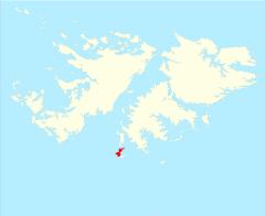
George Island is the second largest of the Speedwell Island Group in the Falkland Islands with a land area of 9 square miles. It lies south of Speedwell Island and south west of East Falkland, and is separated from Lafonia by Eagle Passage. The island is generally flat, rising no more than 59 feet above sea level, and there are several ponds and there is severe soil erosion in the central section. However, the island is free of rats.
George and Barren Islands together are run as a sheep farm, the most southerly in the Falkland Islands. There is also tourism that is well managed.[1]
References
- Stonehouse, B (ed.) Encyclopedia of Antarctica and the Southern Oceans (2002, ISBN 0-471-98665-8)

This Falkland Islands article is a stub: help to improve Wikishire by building it up.
