Pagham: Difference between revisions
Created page with "{{Infobox town |name=Pagham |county=Sussex |picture=Pagham Beach - geograph.org.uk - 97322.jpg |picture caption=Pagham Beach |os grid ref=SZ886975 |latitude=50.77083 |longitud..." |
No edit summary |
||
| (One intermediate revision by the same user not shown) | |||
| Line 14: | Line 14: | ||
|LG district=Arun | |LG district=Arun | ||
|constituency=Bognor Regis and Littlehampton | |constituency=Bognor Regis and Littlehampton | ||
|website=http://www.paghamcouncil.co.uk/ | |website=[http://www.paghamcouncil.co.uk/ paghamcouncil.co.uk] | ||
}} | }} | ||
'''Pagham''' is a coastal village two miles west of [[Bognor Regis]] in [[Sussex]], It has a population of around 6,100. | '''Pagham''' is a coastal village two miles west of [[Bognor Regis]] in [[Sussex]], It has a population of around 6,100. | ||
| Line 32: | Line 32: | ||
==About the village== | ==About the village== | ||
[[Pagham Harbour]] is to the south-west, which has been designated a Site of Special Scientific Interest.<ref>{{sssi|Pagham Harbour}}</ref> The harbour and surrounding land is of national importance for both flora and fauna. The shingle spit is of geological interest. | [[Pagham Harbour]] is to the south-west, which has been designated a Site of Special Scientific Interest.<ref>{{sssi|1000620|Pagham Harbour}}</ref> The harbour and surrounding land is of national importance for both flora and fauna. The shingle spit is of geological interest. | ||
A Phoenix breakwater, a concrete caisson that was intended to be part of a Second World War Mulberry Harbour, is visible in the bay at low tides. | A Phoenix breakwater, a concrete caisson that was intended to be part of a Second World War Mulberry Harbour, is visible in the bay at low tides. | ||
Latest revision as of 23:03, 26 January 2023
| Pagham | |
| Sussex | |
|---|---|
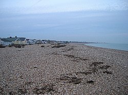
 Pagham Beach | |
| Location | |
| Grid reference: | SZ886975 |
| Location: | 50°46’15"N, -0°44’41"W |
| Data | |
| Population: | 5,941 (Parish, 2011) |
| Post town: | Bognor Regis |
| Postcode: | PO21 |
| Dialling code: | 01243 |
| Local Government | |
| Council: | Arun |
| Parliamentary constituency: |
Bognor Regis and Littlehampton |
| Website: | paghamcouncil.co.uk |
Pagham is a coastal village two miles west of Bognor Regis in Sussex, It has a population of around 6,100.
The village can be divided into three contiguous neighbourhoods (merging seamlessly as one clustered village):
- Pagham Beach, coastal area, developed in the early 20th century,
- Pagham, the original 13th-century village
- Nyetimber: originally a separate village but now subsumed
Pagham has three pubs, 'The Lamb', 'The Lion' and 'The Bear', as well as the 'Inglenook Hotel'.
Many of the original Pagham Beach dwellings are bungalows constructed from old railway carriages - most of these have been later rebuilt using sturdier construction methods.
Parish church
The Church of St. Thomas Becket contains three 1911 windows by the leading painter and designer Edward Arthur Fellowes Prynne, which were restored in 2011.[1]
About the village
Pagham Harbour is to the south-west, which has been designated a Site of Special Scientific Interest.[2] The harbour and surrounding land is of national importance for both flora and fauna. The shingle spit is of geological interest.
A Phoenix breakwater, a concrete caisson that was intended to be part of a Second World War Mulberry Harbour, is visible in the bay at low tides.
Sport and leisure
- Cricket: Pagham Cricket Club, whose ground is at Nyetimber Lane. Sussex County Cricket Club played two first-class matches there in the 1970s.[3]
- Football: Pagham F.C., who play at Nyetimber Lane
The Pagham Pram Race is run on Boxing day every year at 11am whatever the weather. Thousands of people line the streets of Pagham to watch the wacky contestants navigate a three-mile course, drinking three pints of beer en route. All the money raised by the Pram Race is distributed to local good causes.
Outside links
| ("Wikimedia Commons" has material about Pagham) |
References
- ↑ Hammond, Elaine (February 2021). "Church windows restoration 10 years ago was like 'friends coming home'". Chichester Observer. https://www.chichester.co.uk/heritage-and-retro/retro/church-windows-restoration-10-years-ago-was-like-friends-coming-home-3136508.
- ↑ SSSI listing and designation for Pagham Harbour
- ↑ "Ground profile: Pagham Cricket Club Ground". https://cricketarchive.com/Archive/Grounds/11/680.html.
