Thurning, Huntingdonshire: Difference between revisions
Jump to navigation
Jump to search
Created page with '{{infobox town |name=Thurning |county=Northamptonshire |picture=The Old Rectory, Thurning - geograph.org.uk - 230080.jpg |picture caption=The Old Rectory, Thurning |latitude=52.4…' |
No edit summary |
||
| (5 intermediate revisions by 2 users not shown) | |||
| Line 1: | Line 1: | ||
{{infobox town | {{infobox town | ||
|name=Thurning | |name=Thurning | ||
|county=Northamptonshire | |county 1=Huntingdonshire | ||
|county 2=Northamptonshire | |||
|picture=The Old Rectory, Thurning - geograph.org.uk - 230080.jpg | |picture=The Old Rectory, Thurning - geograph.org.uk - 230080.jpg | ||
|picture caption=The Old Rectory, Thurning | |picture caption=The Old Rectory, Thurning | ||
|os grid ref=TL0882 | |||
|latitude=52.4297 | |latitude=52.4297 | ||
|longitude=-0.4057 | |longitude=-0.4057 | ||
| Line 10: | Line 12: | ||
|postcode=PE8 | |postcode=PE8 | ||
|dialling code=01832 | |dialling code=01832 | ||
|LG district=East Northamptonshire | |LG district=East Northamptonshire | ||
|constituency=Corby | |constituency=Corby | ||
}} | }} | ||
'''Thurning''' is a village | '''Thurning''' is a village and parish lying on the [[Huntingdonshire]]-[[Northamptonshire]] border. It is about five and a half miles south-east of [[Oundle]] in the latter county. | ||
At the time of the 2001 census, the population of Thurning Civil Parish was just 93. | At the time of the 2001 census, the population of Thurning Civil Parish was just 93. | ||
==Outside links == | The border between the two counties runs right along the village's main street, with the manor house and parish church lying on the eastern, Huntingdonshire side. The Northamptonshire part of the parish forms part of that county's [[Polebrook Hundred]], with the Huntingdonshire part forming part of the hundred of [[Leightonstone]]. | ||
{{ | |||
*[http://www.genuki.org.uk | ==Outside links== | ||
{{Commons|Thurning,_Northamptonshire}} | |||
*[http://www.genuki.org.uk/big/eng/HUN/Thurning/ GENUKI page] | |||
*[http://www.crsbi.ac.uk/ed/nh/thurn/index.htm Some details of the parish church] | *[http://www.crsbi.ac.uk/ed/nh/thurn/index.htm Some details of the parish church] | ||
{{stub}} | {{stub}} | ||
Latest revision as of 13:45, 20 April 2020
| Thurning | |
| Huntingdonshire, Northamptonshire | |
|---|---|
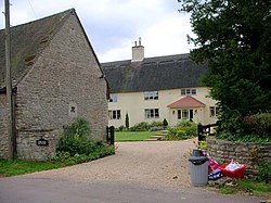
 The Old Rectory, Thurning | |
| Location | |
| Grid reference: | TL0882 |
| Location: | 52°25’47"N, 0°24’21"W |
| Data | |
| Population: | 93 |
| Post town: | Peterborough |
| Postcode: | PE8 |
| Dialling code: | 01832 |
| Local Government | |
| Council: | North Northamptonshire |
| Parliamentary constituency: |
Corby |
Thurning is a village and parish lying on the Huntingdonshire-Northamptonshire border. It is about five and a half miles south-east of Oundle in the latter county.
At the time of the 2001 census, the population of Thurning Civil Parish was just 93.
The border between the two counties runs right along the village's main street, with the manor house and parish church lying on the eastern, Huntingdonshire side. The Northamptonshire part of the parish forms part of that county's Polebrook Hundred, with the Huntingdonshire part forming part of the hundred of Leightonstone.
Outside links
| ("Wikimedia Commons" has material about Thurning, Huntingdonshire) |

This Huntingdonshire article is a stub: help to improve Wikishire by building it up.
