Caher: Difference between revisions
m →Ascent |
No edit summary |
||
| (3 intermediate revisions by the same user not shown) | |||
| Line 7: | Line 7: | ||
|height=3,284 feet | |height=3,284 feet | ||
|os grid ref=V79268389 | |os grid ref=V79268389 | ||
|latitude=51.994684 | |||
|longitude=-9.7587186 | |||
}} | }} | ||
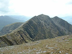
'''Caher''' is mountain in [[County Kerry]], within Ireland's highest range, [[MacGillycuddy's Reeks]]. A bleak, sharp hill, Caher's summit reaches a height of 3,284 feet. Caher stands to the southwest of [[Carrauntoohil]] and it and its west top are the westernmost of the great peaks of the Reeks. | '''Caher''' is mountain in [[County Kerry]], within Ireland's highest range, [[MacGillycuddy's Reeks]]. A bleak, sharp hill, Caher's summit reaches a height of 3,284 feet. Caher stands to the southwest of [[Carrauntoohil]] and it and its west top are the westernmost of the great peaks of the Reeks. | ||
According to Ó Cíobháin, the mountain is also known as ''Cathair na Féinne'', meaning "stone fort of the Fianna" (the legendary warriors of High King Cormac), and this is a name it takes today in the Irish language, though better known in that tongue just as | According to Ó Cíobháin, the mountain is also known as ''Cathair na Féinne'', meaning "stone fort of the Fianna" (the legendary warriors of High King Cormac), and this is a name it takes today in the Irish language, though better known in that tongue just as ''Cathair'' (a word rather similar to the word for "chair" (''cathaoir'') which describes its shape well and which might be another origin of the name. | ||
==West Top== | ==West Top== | ||
Caher West Top ({{lang|ga|Cathair Thiar}}) at {{map|V78998401}} stands at 3,199 feet; not far short of the height of the summit of Caher itself. Caher West Top is considered independent enough in hill lists to be a "Furth Munro" in its own right. | |||
==Ascent== | ==Ascent== | ||
Caher may be climbed | Caher may be climbed from a number of starting points, and presents a hefty climb from all of them. It and Caher West Top are often climbed as part of the "Coomloughra horseshoe". | ||
[[File:The narrow ridge east of Caher - geograph.org.uk - 331991.jpg|right|thumb|220px|The ridge to Carrauntoohil]] | [[File:The narrow ridge east of Caher - geograph.org.uk - 331991.jpg|right|thumb|220px|The ridge to Carrauntoohil]] | ||
Latest revision as of 22:57, 15 November 2017
| Caher | |||
| County Kerry | |||
|---|---|---|---|

| |||
| Range: | MacGillycuddy's Reeks | ||
| Summit: | 3,284 feet V79268389 51°59’41"N, 9°45’31"W | ||
Caher is mountain in County Kerry, within Ireland's highest range, MacGillycuddy's Reeks. A bleak, sharp hill, Caher's summit reaches a height of 3,284 feet. Caher stands to the southwest of Carrauntoohil and it and its west top are the westernmost of the great peaks of the Reeks.
According to Ó Cíobháin, the mountain is also known as Cathair na Féinne, meaning "stone fort of the Fianna" (the legendary warriors of High King Cormac), and this is a name it takes today in the Irish language, though better known in that tongue just as Cathair (a word rather similar to the word for "chair" (cathaoir) which describes its shape well and which might be another origin of the name.
West Top
Caher West Top (Irish: Cathair Thiar) at V78998401 stands at 3,199 feet; not far short of the height of the summit of Caher itself. Caher West Top is considered independent enough in hill lists to be a "Furth Munro" in its own right.
Ascent
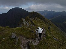
Caher may be climbed from a number of starting points, and presents a hefty climb from all of them. It and Caher West Top are often climbed as part of the "Coomloughra horseshoe".

From Caher a ridge stretches eastwards to Carrauntoohil, Ireland's, and Kerry's, highest mountain, and Caher it often climbed as a preliminary to topping Carrauntoohil.