Radcot: Difference between revisions
Jump to navigation
Jump to search
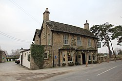
Created page with "{{county|Oxford}} thumb|250px|The Swan Hotel '''Radcot''' is a hamlet in the ancient parish of Langford in [..." |
No edit summary |
||
| Line 1: | Line 1: | ||
{{county|Oxford}} | {{county|Oxford}} | ||
[[File:The Swan Hotel Radcot - geograph.org.uk - 2290007.jpg|thumb|250px|The Swan Hotel]] | [[File:The Swan Hotel Radcot - geograph.org.uk - 2290007.jpg|thumb|250px|The Swan Hotel]] | ||
'''Radcot''' is a hamlet in the ancient parish of [[Langford]] in [[Oxfordshire]]. It is situated adjacent to the [[River Thames]], in the [[Bampton Hundred, Oxfordshire|Bampton Hundred]], two miles south-west of [[Bampton-in-the-Bush]]. The three-arched [[Radcot Bridge]] crosses the Thames here. It was the scene of a battle in 1387, between Robert Vere, Duke of Ireland, and the Earl of Derby, later Henry IV. | '''Radcot''' is a hamlet in the ancient parish of [[Langford, Oxfordshire|Langford]] in [[Oxfordshire]]. It is situated adjacent to the [[River Thames]], in the [[Bampton Hundred, Oxfordshire|Bampton Hundred]], two miles south-west of [[Bampton-in-the-Bush]]. The three-arched [[Radcot Bridge]] crosses the Thames here. It was the scene of a battle in 1387, between Robert Vere, Duke of Ireland, and the Earl of Derby, later Henry IV. | ||
With the neighbouring hamlet of [[ | With the neighbouring hamlet of [[Grafton, Oxfordshire|Grafton]] it has formed the civil parish of ''Grafton and Radcot'' since 1932. | ||
==Outside links== | ==Outside links== | ||
Latest revision as of 07:39, 25 April 2022

Radcot is a hamlet in the ancient parish of Langford in Oxfordshire. It is situated adjacent to the River Thames, in the Bampton Hundred, two miles south-west of Bampton-in-the-Bush. The three-arched Radcot Bridge crosses the Thames here. It was the scene of a battle in 1387, between Robert Vere, Duke of Ireland, and the Earl of Derby, later Henry IV.
With the neighbouring hamlet of Grafton it has formed the civil parish of Grafton and Radcot since 1932.
Outside links
- Locatio nmap: 51°41’42"N, 1°35’38"W

This Oxfordshire article is a stub: help to improve Wikishire by building it up.