Cape Renard: Difference between revisions
No edit summary |
→References: : more specific category |
||
| (2 intermediate revisions by the same user not shown) | |||
| Line 3: | Line 3: | ||
'''Cape Renard''' is a headland on the west coast of [[Graham Land]] in the [[British Antarctic Territory]]. It is designated as the point at which the [[Danco Coast]] ends and the [[Graham Coast]] begins. | '''Cape Renard''' is a headland on the west coast of [[Graham Land]] in the [[British Antarctic Territory]]. It is designated as the point at which the [[Danco Coast]] ends and the [[Graham Coast]] begins. | ||
The cape was roughly charted by the Belgian Antarctic Expedition on 9-12 February 1898, and named ''Cap Renard'' after L'Abbé Prof. Alphonse Renard (1842-1903), a Belgian mineralogist of the University of Ghent, a member of the Belgian Royal Academy and of the | The cape was roughly charted by the Belgian Antarctic Expedition on 9-12 February 1898, and named ''Cap Renard'' after L'Abbé Prof. Alphonse Renard (1842-1903), a Belgian mineralogist of the University of Ghent, a member of the Belgian Royal Academy and of the Belgian Commission. The name 'Mount Renard' has been applied to the summit of the cape, which rises to 2,444 feet above sea level. | ||
The cape was photographed from the air by the Falkland Islands and Dependencies Aerial Survey Expedition and recharted by a Royal Navy Hydrographic Survey Unit from John Biscoe in the 1956-1957 season. | The cape was photographed from the air by the Falkland Islands and Dependencies Aerial Survey Expedition and recharted by a Royal Navy Hydrographic Survey Unit from John Biscoe in the 1956-1957 season. | ||
| Line 16: | Line 16: | ||
==References== | ==References== | ||
*{{basgaz}} | *{{basgaz}} | ||
[[Category:Headlands of Graham Land]] | |||
Latest revision as of 15:37, 15 August 2021

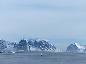
Cape Renard is a headland on the west coast of Graham Land in the British Antarctic Territory. It is designated as the point at which the Danco Coast ends and the Graham Coast begins.
The cape was roughly charted by the Belgian Antarctic Expedition on 9-12 February 1898, and named Cap Renard after L'Abbé Prof. Alphonse Renard (1842-1903), a Belgian mineralogist of the University of Ghent, a member of the Belgian Royal Academy and of the Belgian Commission. The name 'Mount Renard' has been applied to the summit of the cape, which rises to 2,444 feet above sea level.
The cape was photographed from the air by the Falkland Islands and Dependencies Aerial Survey Expedition and recharted by a Royal Navy Hydrographic Survey Unit from John Biscoe in the 1956-1957 season.
See also
Location
- Location map: 65°1’16"S, 63°45’51"W
References
- Gazetteer and Map of The British Antarctic Territory: Cape Renard