Trantlebeg: Difference between revisions
Jump to navigation
Jump to search
Created page with "{{Infobox town |name=Trantlebeg |gaelic=Tranntail Beag |county=Sutherland |picture=A Bridge to Trantlemore - geograph.org.uk - 577852.jpg |picture caption=A Bridge to Trantlem..." |
No edit summary |
||
| Line 14: | Line 14: | ||
|constituency=Caithness, Sutherland and Easter Ross | |constituency=Caithness, Sutherland and Easter Ross | ||
}} | }} | ||
'''Trantlebeg''' is a small village east of the [[Halladale River]] in [[Forsinard]], eastern [[Sutherland]]. | '''Trantlebeg''' is a small village east of the [[Halladale River]] in [[Forsinard]], eastern [[Sutherland]]. It stands opposite [[Trantlemore]], the latter on the river's west bank. | ||
The village of [[Croick]] lies less than a mile, directly north, along the A897 road. | The village of [[Croick]] lies less than a mile, directly north, along the A897 road. | ||
Latest revision as of 13:59, 22 March 2019
| Trantlebeg Gaelic: Tranntail Beag | |
| Sutherland | |
|---|---|
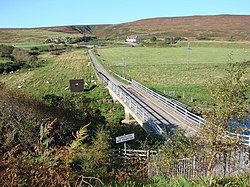
 A Bridge to Trantlemore | |
| Location | |
| Grid reference: | NC898532 |
| Location: | 58°27’12"N, 3°53’36"W |
| Data | |
| Postcode: | KW13 6 |
| Local Government | |
| Council: | Highland |
| Parliamentary constituency: |
Caithness, Sutherland and Easter Ross |
Trantlebeg is a small village east of the Halladale River in Forsinard, eastern Sutherland. It stands opposite Trantlemore, the latter on the river's west bank.
The village of Croick lies less than a mile, directly north, along the A897 road.
Outside links
| ("Wikimedia Commons" has material about Trantlebeg) |
