Skelpick: Difference between revisions
Jump to navigation
Jump to search
Created page with "{{Infobox town |name=Skelpick |gaelic=Sgeilpeach |county=Sutherland |picture=2011 Sutherland River Naver B871 5-06-2011 10-51-37.jpg |picture caption=The River Naver close to..." |
No edit summary |
||
| Line 3: | Line 3: | ||
|gaelic=Sgeilpeach | |gaelic=Sgeilpeach | ||
|county=Sutherland | |county=Sutherland | ||
|picture= | |picture=Tree below Skelpick - geograph-5204734.jpg | ||
|picture caption= | |picture caption=Below Skelpick | ||
|os grid ref=NC722559 | |os grid ref=NC722559 | ||
|latitude=58.4731 | |latitude=58.4731 | ||
Latest revision as of 20:13, 21 March 2019
| Skelpick Gaelic: Sgeilpeach | |
| Sutherland | |
|---|---|
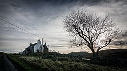
 Below Skelpick | |
| Location | |
| Grid reference: | NC722559 |
| Location: | 58°28’23"N, 4°11’35"W |
| Data | |
| Postcode: | KW14 7 |
| Local Government | |
| Council: | Highland |
| Parliamentary constituency: |
Caithness, Sutherland and Easter Ross |
Skelpick is a small remote crofting hamlet in the far north of Sutherland. It stands on the east bank of the River Naver, four miles south of Bettyhill, at the end of the narrow lane that follows the bank of the Naver into the hills. Eastward of the village is the Skelpick Burn, a short stream which runs north then into the River Naver just below the village.
The hills south of the village, where the road does not follow except as a mere track, are full of ancient hut circles, burnt mounds and cairns.
Outside links
| ("Wikimedia Commons" has material about Skelpick) |
