Overton, North Riding: Difference between revisions
Created page with "{{Infobox town |name=Overton |county=Yorkshire |riding=North |picture=The Road Into Overton - geograph.org.uk - 431770.jpg |picture caption=The Road Into Overton |os grid ref..." |
|||
| (One intermediate revision by the same user not shown) | |||
| Line 27: | Line 27: | ||
[[File:Remains of Cross - geograph.org.uk - 431748.jpg|left|thumb|150px|The cross in Overton]] | [[File:Remains of Cross - geograph.org.uk - 431748.jpg|left|thumb|150px|The cross in Overton]] | ||
The remains of the base of a limestone cross indicate that there may have been a church in the village at one time.<ref>{{OpenDomesday|SE5555|overton|Overton|accessdate=6 January 2013}}</ref><ref name=bul>{{cite book|title=Bulmer's Topography, History and Directory (Private and Commercial) of North Yorkshire 1890 |pages=773, 774|year=1890 |publisher=S&N Publishing|isbn=1-86150-299-0}}</ref><ref>{{ | The remains of the base of a limestone cross indicate that there may have been a church in the village at one time.<ref>{{OpenDomesday|SE5555|overton|Overton|accessdate=6 January 2013}}</ref><ref name=bul>{{cite book|title=Bulmer's Topography, History and Directory (Private and Commercial) of North Yorkshire 1890 |pages=773, 774|year=1890 |publisher=S&N Publishing|isbn=1-86150-299-0}}</ref><ref>{{VCH|2|pp=167-172|Parishes: Overton}}</ref> | ||
==Geography== | ==Geography== | ||
The nearest settlements are [[Skelton, | The nearest settlements are [[Skelton, York|Skelton]] a mile to the east; [[Nether Poppleton]] half a mile to the south across the [[River Ouse, Yorkshire|River Ouse]]; [[Beningbrough]] two and a half miles to the north-west and [[Shipton, Yorkshire|Shipton]] two miles to the north. | ||
Overton stands lies on the north bank of the River Ouse, from which position it takes its name; the Old English ''Ofer tun'' means "Riverbank farmstead". | Overton stands lies on the north bank of the River Ouse, from which position it takes its name; the Old English ''Ofer tun'' means "Riverbank farmstead". | ||
Latest revision as of 14:06, 3 March 2021
| Overton | |
| Yorkshire North Riding | |
|---|---|
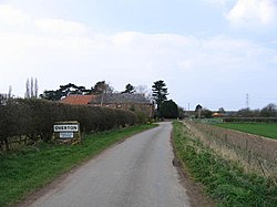
 The Road Into Overton | |
| Location | |
| Grid reference: | SE554557 |
| Location: | 53°59’40"N, 1°9’24"W |
| Data | |
| Post town: | York |
| Postcode: | YO30 |
| Local Government | |
| Council: | Hambleton |
| Parliamentary constituency: |
Thirsk and Malton |
Overton is a small village in the North Riding of Yorkshire, about our miles north-west of York. The population of parish taken at the 2011 Census was less than 100.
The East Coast Main Line passes to the east, not far from the village.
History
The village is mentioned three times in the Domesday Book as Ovretun in the Bulford hundred. The manor belonged before the Conquest to Earl Morcar, who had a hall in the village. Some of the land was the possession of the Church of St Peter in York and of Thorbiorn. The manor passed to the Crown and Count Alan of Brittany by 1086. Both granted the manor to St Mary's Abbey, York. The Hall that once stood in the village was the country seat of the Abbots until the dissolution.
The Hall was demolished at some time in the 18th century, though earthworks indicate where the old moat may have been. Eventually the manor and estate came into the hands of the Bourchier family, and thence the Dawnay family.
The parish was once much larger and included the manors of Shipton and Skelton.

The remains of the base of a limestone cross indicate that there may have been a church in the village at one time.[1][2][3]
Geography
The nearest settlements are Skelton a mile to the east; Nether Poppleton half a mile to the south across the River Ouse; Beningbrough two and a half miles to the north-west and Shipton two miles to the north.
Overton stands lies on the north bank of the River Ouse, from which position it takes its name; the Old English Ofer tun means "Riverbank farmstead".
Outside links
| ("Wikimedia Commons" has material about Overton, North Riding) |
References
- ↑ Overton in the Domesday Book
- ↑ Bulmer's Topography, History and Directory (Private and Commercial) of North Yorkshire 1890. S&N Publishing. 1890. pp. 773, 774. ISBN 1-86150-299-0.
- ↑ A History of the County of York: North Riding - Volume 2 pp 167-172: Parishes: Overton (Victoria County History)
