Brushford, Devon: Difference between revisions
Jump to navigation
Jump to search
Created page with "{{Infobox town |name=Brushford |county=Devon |picture=Brushford Church - geograph.org.uk - 79380.jpg |picture caption=Brushford parish church |os grid ref=SS675076 |latitude=5..." |
No edit summary |
||
| Line 15: | Line 15: | ||
|constituency= | |constituency= | ||
}} | }} | ||
'''Brushford''' is a hamlet in [[Devon]], on the [[River Taw | '''Brushford''' is a hamlet in [[Devon]], on the [[River Taw]] about twelve miles north-east of [[Okehampton]]. According to the 2001 census, the village had a population of 59. | ||
The church has a Norman doorway, 16th century screen and Jacobean pulpit. | The church has a Norman doorway, 16th-century screen and Jacobean pulpit. | ||
==Outside links== | ==Outside links== | ||
Latest revision as of 19:23, 29 June 2018
| Brushford | |
| Devon | |
|---|---|
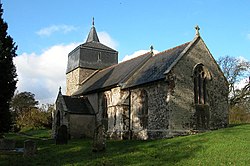
 Brushford parish church | |
| Location | |
| Grid reference: | SS675076 |
| Location: | 50°51’11"N, 3°52’58"W |
| Data | |
| Post town: | Chulmleigh |
| Postcode: | EX18 |
| Local Government | |
| Council: | Mid Devon |
Brushford is a hamlet in Devon, on the River Taw about twelve miles north-east of Okehampton. According to the 2001 census, the village had a population of 59.
The church has a Norman doorway, 16th-century screen and Jacobean pulpit.
Outside links
| ("Wikimedia Commons" has material about Brushford, Devon) |
