Beare: Difference between revisions
Jump to navigation
Jump to search
Created page with "{{distinguish|Beer}} {{Infobox town |name=Beare |county=Devon |picture=Beare_Farm_-_geograph.org.uk_-_1800207.jpg |picture caption=Beare Farm |os grid ref=SS988011 |latitude=5..." |
No edit summary |
||
| (One intermediate revision by the same user not shown) | |||
| Line 6: | Line 6: | ||
|picture caption=Beare Farm | |picture caption=Beare Farm | ||
|os grid ref=SS988011 | |os grid ref=SS988011 | ||
|latitude=50.801332 | |latitude=50.801332 | ||
|longitude=-3.43645 | |longitude=-3.43645 | ||
|population= | |population= | ||
| Line 15: | Line 15: | ||
|constituency= | |constituency= | ||
}} | }} | ||
'''Beare''' is a village in eastern [[Devon]] (17 miles north-west of its homophonous namesake, [[Beer]]; also in Devon). | '''Beare''' is a village in eastern [[Devon]] (17 miles north-west of its homophonous namesake, [[Beer, Devon|Beer]]; also in Devon). | ||
The village is squashed against the [[M5 motorway]], and sits between two [[National Trust for Places of Historic Interest or Natural Beauty|National Trust]] properties: [[Ashclyst Forest]] to the east and [[Killerton Park]] to the west. | The village is squashed against the [[M5 motorway]], and sits between two [[National Trust for Places of Historic Interest or Natural Beauty|National Trust]] properties: [[Ashclyst Forest]] to the east and [[Killerton Park]] to the west. | ||
Latest revision as of 22:05, 19 February 2023
- Not to be confused with Beer
| Beare | |
| Devon | |
|---|---|
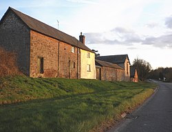
 Beare Farm | |
| Location | |
| Grid reference: | SS988011 |
| Location: | 50°48’5"N, 3°26’11"W |
| Data | |
| Post town: | Exeter |
| Postcode: | EX5 |
| Local Government | |
Beare is a village in eastern Devon (17 miles north-west of its homophonous namesake, Beer; also in Devon).
The village is squashed against the M5 motorway, and sits between two National Trust properties: Ashclyst Forest to the east and Killerton Park to the west.
Outside links
| ("Wikimedia Commons" has material about Beare) |
