Pettigo: Difference between revisions
Created page with "{{Infobox town |name=Pettigo |irish=Paiteagó |county=Donegal |picture=Pettigo Inn - geograph.org.uk - 449700.jpg |picture caption=Pettigo village centre |os grid ref=H105669..." |
m clean up |
||
| Line 77: | Line 77: | ||
==Lough Derg== | ==Lough Derg== | ||
Lough Derg, the biggest of the Pettigo lakes, is famous throughout the | Lough Derg, the biggest of the Pettigo lakes, is famous throughout the north-west for its trout-fishing. Covering 2,200 acres with a shore line of 13 miles, it offers opportunities for both boat and shore angling. It also offers excellent pike fishing. Lough Derg lies wholly within [[County Donegal]], about four miles north of Pettigo. | ||
[[Station Island]], the location of the Lough Derg Pilgrimage, is often referred to as [[Saint Patrick's Purgatory]] or simply Lough Derg. This small lake-island, renowned in Irish tradition since the Middle Ages (and allegedly since the time of St Patrick), has been receiving pilgrims continuously for well over 1000 years for a rather cruel pilgrimage ordeal. | [[Station Island]], the location of the Lough Derg Pilgrimage, is often referred to as [[Saint Patrick's Purgatory]] or simply Lough Derg. This small lake-island, renowned in Irish tradition since the Middle Ages (and allegedly since the time of St Patrick), has been receiving pilgrims continuously for well over 1000 years for a rather cruel pilgrimage ordeal. | ||
Latest revision as of 12:16, 2 August 2017
| Pettigo Irish: Paiteagó | |
| County Donegal | |
|---|---|
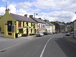
 Pettigo village centre | |
| Location | |
| Grid reference: | H105669 |
| Location: | 54°32’56"N, 7°49’52"W |
| Data | |
| Population: | 424 (est.) |
| Local Government | |
Pettigo (also spelt Pettigoe) is a small, cross-border village in County Donegal in the Republic of Ireland, with a part or counterpart, Tullyhommon in Fermanagh in United Kingdom. The two are divided by the Termon River, which here marks the border between the two counties and two countries.
The portion of the village in Fermanagh is called Tullyhommon, but is locally known as 'High Street' due to its hillside position overlooking the remainder of the village. The rest of the village, in Donegal, includes Main Street, Mill Street and Station Street, all of which meet in The Diamond at the centre of the village. There are also two relatively modern housing estates on the northern outskirts, namely Termon Villas and St Patrick's Terrace along with new developments such as Mill Grove.
Until the late 1700s, the area was known as in the Irish language as 'An Tearmann', meaning 'the place of sanctuary'. The modern name (in both e the English and Irish languages) derives from the Latin protectio, meaning "protection", from the same origin.
Economy
Once a thriving market village on the Enniskillen and Bundoran Railway, the village suffered from partition in 1922, then the closure of the railway in 1957, and as the Troubles reached their height it suffered through the closure of numerous cross-border roads. The latter had the effect of cutting Pettigo off from much of its rural hinterland in Fermanagh and Tyrone.
In recent years economic prospects have improved with the reopening of many of the cross-border roads, improving access for tourists and locals alike.
Agriculture, particularly the rearing of sheep and cattle, forms the mainstay of the local economy. The quality of the local land (marshy, with much blanket bog) renders it largely unsuitable for grain crops. There are also expansive forestry plantations in the surrounding townlands, owned and operated by Coillte Teoranta, the Republic's Forestry Service. Many of the plantations occupy land unsuitable for other commercial uses, or where peat extraction has been completed, leaving poor quality thin soil cover behind. The Sitka Spruce and Lodgepole Pine softwood varieties comprise 90% of the canopy.
Pettigo has traditionally been the 'gateway' to St Patrick's Purgatory, a Roman Catholic pilgrimage site on an island in Lough Derg. During the mid-late 20th century, the popularity of the pilgrimage brought a significant boost to the local economy as tens of thousands of pilgrims from all over Ireland and abroad travelled through the village on their way to and from Lough Derg. Although the popularity of the pilgrimage has dwindled in recent years, it is still an important driver of tourism in the area.
Fighting in 1922

In June 1922, at the tail end of the Irish War of Independence, both Pettigo and Belleek (in Fermanagh) were occupied by a 100-strong unit of the Irish Republican Army, who had arrived there from Donegal. They were attacked first by a party of 100 Ulster Special Constabulary, who crossed Lough Erne but they were beaten off, losing one killed. Two companies of British Army soldiers, with 6 field guns and the Special Constabulary unit were sent to take the villages: in the ensuing fighting, in which the British bombarded Pettigoe and then stormed it, the IRA lost three men killed, six wounded and four captured before being forced to retreat back to Donegal. One British soldier was killed in the fighting. Two civilians were also shot dead in nearby Lettercan.[1]
A memorial was erected in 1953 on the Irish side to commemorate four men who died in the action in of Pettigo.
Churches
The local area has a mixed religious make-up, with the village having Roman Catholic]], Church of Ireland, Presbyterian and Methodist Churches.

Railway

The Enniskillen and Bundoran Railway opened from Bundoran Junction}} on the Londonderry and Enniskillen Railway near Kilskeery, Co. Tyrone to Pettigo on 13 June 1866.[2] It was extended Bundoran, Co. Donegal in 1868[3] and intended to continue to Sligo but failed to do so.[4] The Great Northern Railway ran the E&BR from 1876 and took it over in 1896.[5]
Pettigo railway station was opened in 1866 but it incorporated a house that had been built in 1840. Trains from Pettigo went to Dublin Amiens Street, Enniskillen, Belleek, Ballyshannon and Bundoran. Thirty men kept the railway in running repair. Water supplies for the steam locomotives was drawn from the Termon River.
The railway greatly aided the movement and export of agricultural produce such as sheep and cattle and the import and distribution of coal, building materials and imported food. Livestock were loaded onto the train from the nearby Pettigo Market Yard.
The railway also carried visitors to the developing seaside resort of Bundoran whose first hotel, the Hamilton Hotel, was built by Pettigo man, Hazlett Hamilton, who was a major property owner in Pettigo. The railway also enhanced access to the Lough Derg pilgrimage for people from all over Ireland.
Both the partition of Ireland in 1922 and increasing road transport weakened the railway. The Government of Northern Ireland made the GNR close nearly all of its cross-border lines, including the Bundoran branch, on 1 October 1957.[6]
Castle McGrath
Castle McGrath was built in the 1600s, Bishop Miler McGrath lived in the Castle. The Castle was besieged and captured during the 1641 rebellion and soon after abandoned. The castle and lands were sold to the Leslie family of County Monaghan who controlled the Pettigo estate until the early 20th century.
The Mill

Pettigo Mill was built by the Leslie family who owned the Pettigo Estate. The Leslie family were originally from Monaghan town. Pettigo Mill was first on the map of Pettigo dated 1767, but probably is much older. The mill got its power from the Termon River. It was described as a cloth mill but probably also ground oats and other grains. During the famine, maize or Indian meal as it was called was ground in the Pettigo Mill. This was then sent to the poor through the port of Ballyshannon in the year 1845/1846. After the arrival of the railway in Pettigo, which opened in 1860, Pettigo Mill was a saw mill as well as a grain mill. Timber for all the usual purposes was produced but the main product that was made was egg boxes which held twelve eggs. Eggs were sent by train to the cities of Belfast and Dublin or onto Great Britain. Egg boxes were in great demand as many people depended on their egg money to buy their groceries in the local shops.
The Termon Complex
On the Donegal side, a brand new community initiative by the Association for Development of Pettigo & Tullyhommon has built a sports, leisure and entertainment complex on the banks of the River Termon. The project has been lavishly funded with taxpayers' money from both sides of the border and from the European Commission.
- Different spaces within the building which will facilitate indoor sports, large meetings/conferences, drama productions & concerts - including a main hall, conference room and meeting rooms.
- ADoPT offices
- A purpose built Gym
- An outdoor multi-use games area (MUGA)
- A new playschool with secure private playground
- A new public playground and community garden
- Recycling space, car parking and horticultural tunnels
Walks
The Mountains, hills and quiet country roads offer space for hill-walking, cycling and pony trekking.
The Pettigo History trail is centred round the village and can be explored at the hiker's leisure. The trail entails the history and heritage of the Pettigo area, and is littered with 30 plaques with information on such things as Riverdance, the Crimean War Tree and the Pettigo Connection to "The Quiet Man" among many other tales of the areas surrounded by lakes.

Lakes / angling
Lying between Lough Erne and Lough Derg, Pettigo is able to offer the visiting angler a full range of fishing opportunities. With over fifty lakes; salmon and native brown trout will keep the game angler happy while the coarse angler will find specimen fish in Drumgun Lough. Fishing permits and boat hire is available.[7]
Lough Derg
Lough Derg, the biggest of the Pettigo lakes, is famous throughout the north-west for its trout-fishing. Covering 2,200 acres with a shore line of 13 miles, it offers opportunities for both boat and shore angling. It also offers excellent pike fishing. Lough Derg lies wholly within County Donegal, about four miles north of Pettigo.
Station Island, the location of the Lough Derg Pilgrimage, is often referred to as Saint Patrick's Purgatory or simply Lough Derg. This small lake-island, renowned in Irish tradition since the Middle Ages (and allegedly since the time of St Patrick), has been receiving pilgrims continuously for well over 1000 years for a rather cruel pilgrimage ordeal.
In earlier times the area around the lake was a place of protection for anyone in trouble. The monastery nearby offered hospitality to all.
Outside links
References
- ↑ Robert Lynch, The Northern IRA and the early years of Partition, 1920-1922, p154-156
- ↑ "Pettigo station" (PDF). Railscot – Irish Railways. http://www.railscot.co.uk/Ireland/Irish_railways.pdf. Retrieved 2007-11-22.
- ↑ Hajducki, 1974, maps 6, 7
- ↑ Sprinks 1970, p. 8.
- ↑ Hajducki 1974.
- ↑ Baker 1972, pp. 153, 207.
- ↑ Brittons Bar
- Baker, Michael H.C. (1972). Irish Railways since 1916. London: Ian Allan. ISBN 0-7110-0282-7.
- Hajducki, S. Maxwell (1974). A Railway Atlas of Ireland. Newton Abbott: David & Charles. maps 6, 7, page xiii. ISBN 0-7153-5167-2.
- Sprinks, N.W. (1970). Sligo, Leitrim and Northern Counties Railway. Billericay: Irish Railway Record Society (London Area).