Bridgerule: Difference between revisions
Created page with "{{Infobox town |name=Bridgerule |county 1=Cornwall |county 2=Devon |picture=St Bridget's Church - geograph.org.uk - 253382.jpg |picture caption=St Bridget's Church |os grid re..." |
No edit summary |
||
| Line 10: | Line 10: | ||
|population=570 | |population=570 | ||
|constituency= | |constituency= | ||
|post town= | |post town=Holsworthy | ||
|postcode= | |postcode=EX22 | ||
|dialling code= | |dialling code=01288 | ||
|LG district=Torridge | |LG district=Torridge | ||
}} | }} | ||
'''Bridgerule''' is a village which stretches across the border of [[Devon]] with [[Cornwall]], which is marked by the [[River Tamar]]. The Tamar runs through the middle of the village, the greater part of Bridgerule being on the western side, in | '''Bridgerule''' is a village and parish which stretches across the border of [[Devon]] with [[Cornwall]], which is marked by the [[River Tamar]]. The Tamar runs through the middle of the village, the greater part of Bridgerule being on the western side in Cornwall, although the parish church lies in Devon. The river often floods the High Street. | ||
The village population, including both sides, at the 2011 census was 1,734. | The village population, including both sides, at the 2011 census was 1,734. | ||
Latest revision as of 16:17, 5 February 2021
| Bridgerule | |
| Cornwall, Devon | |
|---|---|
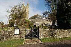
 St Bridget's Church | |
| Location | |
| Grid reference: | SS2702 |
| Location: | 50°47’24"N, 4°27’0"W |
| Data | |
| Population: | 570 |
| Post town: | Holsworthy |
| Postcode: | EX22 |
| Dialling code: | 01288 |
| Local Government | |
| Council: | Torridge |
Bridgerule is a village and parish which stretches across the border of Devon with Cornwall, which is marked by the River Tamar. The Tamar runs through the middle of the village, the greater part of Bridgerule being on the western side in Cornwall, although the parish church lies in Devon. The river often floods the High Street.
The village population, including both sides, at the 2011 census was 1,734.
History
Bridgerule is mentioned (as Brige) in the Domesday Book in 1086, when the local manor was held by a Norman, Ruald Adobed. The name is thought to come from bridge and Ruald's name.[1]
Whitstone and Bridgerule railway station on the line from Okehampton to Bude served the village, opening in 1898 and closing in 1966.
Church
There is a 15th-century church dedicated, as at Bridestowe, to St Bridget, who is commemorated with a statue. There are also several paintings and carvings within. The font is very old, dating from Saxon times.
Outside links
| ("Wikimedia Commons" has material about Bridgerule) |
