Lord Hereford's Knob: Difference between revisions
Created page with '{{Infobox hill |name=Lord Hereford's Knob |welsh=Twmpa |county=Brecknockshire |picture=Twmpa.jpg |picture caption=Lord Hereford's Knob |height= 2,260 feet |range=Black Mountains …' |
mNo edit summary |
||
| (One intermediate revision by the same user not shown) | |||
| Line 8: | Line 8: | ||
|range=Black Mountains | |range=Black Mountains | ||
|os grid ref=SO224350 | |os grid ref=SO224350 | ||
|latitude=52.007987 | |||
|longitude=-3.131959 | |||
}} | }} | ||
'''Lord Hereford's Knob''' or '''Twmpa''' is a mountain 2,260 feet high in eastern [[Brecknockshire]], immediately | '''Lord Hereford's Knob''' or '''Twmpa''' is a mountain 2,260 feet high in eastern [[Brecknockshire]], immediately north-east of [[Rhos Dirion]] and south-west of [[Hay Bluff]]. It is two miles west of the border with [[Herefordshire]] and around five miles east of [[Talgarth]] and the same south of [[Hay-on-Wye]]. | ||
The mountain forms part of the great | The mountain forms part of the great north-west scarp of the [[Black Mountains]]. To the north-east lies the [[Gospel Pass]] through which runs a minor road between Hay and the Llanthony Valley. A ridge known as Darren Lwyd tapers away for about two miles to the south-east of the summit. | ||
==Walking== | ==Walking== | ||
The entire hill is classed as open country under the Countryside and Rights of Way Act and is therefore available for walkers to roam freely across. It is almost encircled by public bridleways and restricted byways. The most well-used track is that running west from Gospel Pass (where car parking is available), over its summit and then | The entire hill is classed as open country under the Countryside and Rights of Way Act and is therefore available for walkers to roam freely across. It is almost encircled by public bridleways and restricted byways. The most well-used track is that running west from Gospel Pass (where car parking is available), over its summit and then south-west towards [[Rhos Dirion]]. A further track runs the length of the ridge south-eastwards to the hamlet of [[Capel-y-ffin]]. | ||
==Geology== | ==Geology== | ||
| Line 22: | Line 24: | ||
==Trivia== | ==Trivia== | ||
"Lord Hereford's Knob" is the title of a song on Half Man Half Biscuit's 2008 album ''CSI: Ambleside''. The lyrics feature the grid reference of the mountain.<ref>Nuttall, John & Anne (1999). The Mountains of England & Wales - Volume 1: Wales (2nd edition ed.). Milnthorpe, | "Lord Hereford's Knob" is the title of a song on Half Man Half Biscuit's 2008 album ''CSI: Ambleside''. The lyrics feature the grid reference of the mountain.<ref>Nuttall, John & Anne (1999). The Mountains of England & Wales - Volume 1: Wales (2nd edition ed.). Milnthorpe, Westmorland: Cicerone. ISBN 1-85284-304-7.</ref> | ||
==Outside links== | ==Outside links== | ||
Latest revision as of 08:13, 3 October 2017
| Lord Hereford's Knob | |||
| Brecknockshire | |||
|---|---|---|---|
 Lord Hereford's Knob | |||
| Range: | Black Mountains | ||
| Summit: | 2,260 feet SO224350 52°0’29"N, 3°7’55"W | ||
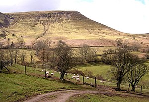
Lord Hereford's Knob or Twmpa is a mountain 2,260 feet high in eastern Brecknockshire, immediately north-east of Rhos Dirion and south-west of Hay Bluff. It is two miles west of the border with Herefordshire and around five miles east of Talgarth and the same south of Hay-on-Wye.
The mountain forms part of the great north-west scarp of the Black Mountains. To the north-east lies the Gospel Pass through which runs a minor road between Hay and the Llanthony Valley. A ridge known as Darren Lwyd tapers away for about two miles to the south-east of the summit.
Walking
The entire hill is classed as open country under the Countryside and Rights of Way Act and is therefore available for walkers to roam freely across. It is almost encircled by public bridleways and restricted byways. The most well-used track is that running west from Gospel Pass (where car parking is available), over its summit and then south-west towards Rhos Dirion. A further track runs the length of the ridge south-eastwards to the hamlet of Capel-y-ffin.
Geology
In common with neighbouring hills, Lord Hereford's Knob is composed of alternate layers of sandstone and mudstone dating from the Devonian period and ascribed to the Lower Old Red Sandstone. Its lower slopes are formed from the mudstone-dominated St Maughans Formation whilst the upper part of the hill is composed of sandstone-dominated Senni Formation rocks. At the junction between the two is a prominent calcrete known as the Ffynnon Limestone.
Numerous landslips have occurred within the St Maughans Formation around the flanks of the hill.[1]
Trivia
"Lord Hereford's Knob" is the title of a song on Half Man Half Biscuit's 2008 album CSI: Ambleside. The lyrics feature the grid reference of the mountain.[2]