Manor Water: Difference between revisions
Jump to navigation
Jump to search
Created page with "{{county|Peeblesshire}} thumb|250px|Manor Bridge The '''Manor Water''' is a river that flows entirely with..." |
No edit summary |
||
| Line 1: | Line 1: | ||
{{county|Peeblesshire}} | {{county|Peeblesshire}} | ||
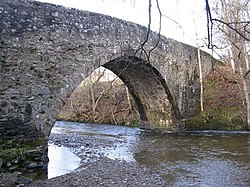
[[File:Bridge over the Manor Water - geograph.org.uk - 1609249.jpg|thumb|250px|Manor | [[File:Bridge over the Manor Water - geograph.org.uk - 1609249.jpg|thumb|250px|The Old Manor Brig, built in 1702]] | ||
The '''Manor Water''' is a river that flows entirely within the parish of [[Manor]], [[Peeblesshire]]. It rises in the [[Ettrick Forest]] and flows down through the Manor valley passing the various farms and hamlets of Manor as well as Kirkton Mannor where the Manor kirk and village hall are, flowing into the [[River Tweed]] one mile south of [[Peebles]] at Manor Bridge. | The '''Manor Water''' is a river that flows entirely within the parish of [[Manor]], [[Peeblesshire]]. It rises in the [[Ettrick Forest]] and flows down through the Manor valley passing the various farms and hamlets of Manor as well as Kirkton Mannor where the Manor kirk and village hall are, flowing into the [[River Tweed]] one mile south of [[Peebles]] at Manor Bridge. | ||
Latest revision as of 14:10, 16 May 2016

The Manor Water is a river that flows entirely within the parish of Manor, Peeblesshire. It rises in the Ettrick Forest and flows down through the Manor valley passing the various farms and hamlets of Manor as well as Kirkton Mannor where the Manor kirk and village hall are, flowing into the River Tweed one mile south of Peebles at Manor Bridge.
Outside links
- Location map: 55°37’59"N, 3°13’59"W
- CRCAHMS/Canmore record: Old Manor Bridge, Manor Water
- Gazetteer for Scotland: Manor Water
- Streetmap of Manor Water
- Borders Family History Society: Manor
This Peeblesshire article is a stub: help to improve Wikishire by building it up.