Wedder Law: Difference between revisions
Jump to navigation
Jump to search
Created page with "{{Infobox hill |name=Wedder Law |county 1=Kirkcudbrightshire |county 2=Lanarkshire |range=Lowther Hills |picture=Wedder_Law_-_geograph.org.uk_-_438274.jpg |picture caption=On ..." |
No edit summary |
||
| Line 1: | Line 1: | ||
{{Infobox hill | {{Infobox hill | ||
|name=Wedder Law | |name=Wedder Law | ||
|county 1= | |county 1=Dumfriesshire | ||
|county 2=Lanarkshire | |county 2=Lanarkshire | ||
|range=Lowther Hills | |range=Lowther Hills | ||
| Line 9: | Line 9: | ||
|latitude=55.305386 | |latitude=55.305386 | ||
|longitude=-3.673084 | |longitude=-3.673084 | ||
|height= | |height=2,205 ft | ||
}} | }} | ||
'''Wedder Law''' is a hill of | '''Wedder Law''' is a hill of 2,205 feet in the [[Lowther Hills]]. It is on the watershed between the [[Solway Firth|Solway]] and [[River Clyde|Clyde]] streams and is one of the summits which marks the border between [[Lanarkshire]] on the east, draining to the Clyde, and [[Dumfriesshire]] to the west, draining to the Solway. | ||
Latest revision as of 21:08, 20 March 2017
| Wedder Law | |||
| Dumfriesshire, Lanarkshire | |||
|---|---|---|---|
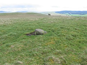
 On Wedder Law | |||
| Range: | Lowther Hills | ||
| Summit: | 2,205 ft NS938025 55°18’19"N, 3°40’23"W | ||
Wedder Law is a hill of 2,205 feet in the Lowther Hills. It is on the watershed between the Solway and Clyde streams and is one of the summits which marks the border between Lanarkshire on the east, draining to the Clyde, and Dumfriesshire to the west, draining to the Solway.