Liddesdale: Difference between revisions
Created page with "right|thumb|300px|View over Liddesdale {{county|Roxburghshire}} '''Liddesdale''', the valley of the Liddel Water..." |
mNo edit summary |
||
| Line 1: | Line 1: | ||
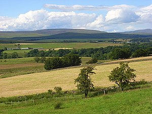
[[File:View over Liddesdale - geograph.org.uk - 900978.jpg|right|thumb|300px|View over Liddesdale]] | [[File:View over Liddesdale - geograph.org.uk - 900978.jpg|right|thumb|300px|View over Liddesdale]] | ||
{{county|Roxburghshire}} | {{county|Roxburghshire}} | ||
'''Liddesdale''' | '''Liddesdale''' is the valley of the [[Liddel Water]], in [[Roxburghshire]]. It contains the greater part of the villages of the county east of the Tweed watershed, extending in a south-westerly direction from the vicinity of [[Peel Fell]] to the [[River Esk, Dumfriesshire|River Esk]], a distance of 21 miles. The Waverley route of the North British Railway runs down the dale, and the [[Catrail]], or Picts' Dyke, crosses its head. | ||
Liddesdale was reckoned an historic district of the old borders, a natural district bordering [[Teviotdale]] to the east, [[Annandale]] to the west and [[Tweeddale]] to the north. In the unquiet | Liddesdale was reckoned an historic district of the old borders, a natural district bordering [[Teviotdale]] to the east, [[Annandale]] to the west and [[Tweeddale]] to the north. In the unquiet days before the Union of the Crowns, Liddesdale was within the authority of the Sheriff of [[Roxburgh]] but in truth a lawless hide-out for the most notorious of the reiver families. After the accession of King James VI to the English throne, the Pacification of the Borders | ||
At one period the points of vantage on the river and its affluents were occupied with freebooters' peel towers, but many of them have disappeared and the remainder are in decay. Larriston Tower belonged to the Elliots, Mangerton, now little more than a site, to the Armstrongs and Park to "Little Jock Elliot", the outlaw who nearly killed James Hepburn, 4th Earl of Bothwell in an encounter in 1566. Hollows Tower, Johnnie Armstrong's peel, is in good condition; it is on the A7, about four miles south of [[Langholm]]. | At one period the points of vantage on the river and its affluents were occupied with freebooters' peel towers, but many of them have disappeared and the remainder are in decay. Larriston Tower belonged to the Elliots, Mangerton, now little more than a site, to the Armstrongs and Park to "Little Jock Elliot", the outlaw who nearly killed James Hepburn, 4th Earl of Bothwell in an encounter in 1566. Hollows Tower, Johnnie Armstrong's peel, is in good condition; it is on the A7, about four miles south of [[Langholm]]. | ||
Latest revision as of 21:06, 11 November 2014

Liddesdale is the valley of the Liddel Water, in Roxburghshire. It contains the greater part of the villages of the county east of the Tweed watershed, extending in a south-westerly direction from the vicinity of Peel Fell to the River Esk, a distance of 21 miles. The Waverley route of the North British Railway runs down the dale, and the Catrail, or Picts' Dyke, crosses its head.
Liddesdale was reckoned an historic district of the old borders, a natural district bordering Teviotdale to the east, Annandale to the west and Tweeddale to the north. In the unquiet days before the Union of the Crowns, Liddesdale was within the authority of the Sheriff of Roxburgh but in truth a lawless hide-out for the most notorious of the reiver families. After the accession of King James VI to the English throne, the Pacification of the Borders
At one period the points of vantage on the river and its affluents were occupied with freebooters' peel towers, but many of them have disappeared and the remainder are in decay. Larriston Tower belonged to the Elliots, Mangerton, now little more than a site, to the Armstrongs and Park to "Little Jock Elliot", the outlaw who nearly killed James Hepburn, 4th Earl of Bothwell in an encounter in 1566. Hollows Tower, Johnnie Armstrong's peel, is in good condition; it is on the A7, about four miles south of Langholm.

Hermitage Castle
- Main article: Hermitage Castle
The chief point of interest in the dale is Hermitage Castle, a massive H-shaped fortress of enormous strength, one of the oldest surviving castles in Scotland. It stands on a hill overlooking Hermitage Water, a tributary of the Liddel. It was built in 1244 by Nicholas de Soulis, and was captured by the English in the reign of King David II. It was retaken by Sir William Douglas, who received a grant of it from the king. In 1492 Archibald Douglas, 5th Earl of Angus, exchanged the castle for Bothwell Castle on the Clyde with Patrick Hepburn, 1st Earl of Bothwell. It finally passed to the Duke of Buccleuch, under whose care further ruin has been arrested.
It was at Hermitage Castle that Sir Alexander Ramsay of Dalhousie was starved to death by Sir William Douglas in 1342, and that James Hepburn, 4th Earl of Bothwell, was visited by Mary, Queen of Scots, after his escape from death at the hands of the outlaw Jock Elliot.
About the dale
The castle of the lairds of Liddesdale stood near the junction of Hermitage Water and the Liddel, and around it grew up the village of Newcastleton.
Peel towers of the reivers remain in places, most though were abandoned when the Middle Shires were forceably pacified. Hermitage Castle is the greatest remaining fortification.
To the east of Hermitage Castle is Ninestane Rig, a hill 943 feet high, four miles long and one mile broad. Here it is said that William de Soulis, hated for oppression and cruelty, was (in 1320) boiled by his own vassals in a copper cauldron, which was supported on two of the nine stones which composed the "Druidical" circle that gave the ridge its name. Only five of the stones remain.
Liddel Strength remains only as earthworks on the Cumberland bank of the Liddel Water. It was a Norman castle built to defend the dale.
James Telfer (1802–1862), the writer of ballads, who was born in the parish of Southdean (pronounced Soudan), was for several years schoolmaster of Saughtree, near the head of the dale.