Knocknacarry: Difference between revisions
Jump to navigation
Jump to search
Created page with '{{Infobox town |name=Knocknacarry |county=Antrim |picture= |picture caption= |os grid ref=D2432 |LG district=Moyle }} '''Knocknacarry''' is a village in County Antrim. {{stu…' |
No edit summary |
||
| (2 intermediate revisions by 2 users not shown) | |||
| Line 2: | Line 2: | ||
|name=Knocknacarry | |name=Knocknacarry | ||
|county=Antrim | |county=Antrim | ||
|picture= | |picture=Knockacully - geograph.org.uk - 465576.jpg | ||
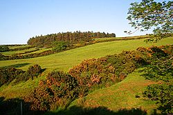
|picture caption= | |picture caption=Hillside by Knockacully | ||
|os grid ref= | |os grid ref=D241322 | ||
|LG district= | |latitude=55.122281 | ||
|longitude=-6.0546148 | |||
|postcode=BT44 | |||
|post town=Ballymena | |||
|population= | |||
|census year= | |||
|LG district=Antrim Coast and Glens | |||
|constituency= | |||
|townland=yes | |||
}} | }} | ||
'''Knocknacarry''' is a | '''Knocknacarry''' is a hamlet in the north-east of [[County Antrim]], and a townland of 155 acres, about half a mile west of [[Cushendun]] (within the Barony of [[Glenarm Lower]]). The 2011 census recorded a population of 138 people. | ||
The name of the place is from the Irish language; ''Cnoc na Caraidh'' means "Hill of the weir", which refers to a weir diverting a millstream off the River Dun. | |||
{{ | Knocknacarry lies within the Antrim Coast and Glens Area of Outstanding Natural Beauty. St Ciaran's Primary School, which also serves the village of Cushendun and the wider local area, is in Knocknacarry. | ||
The river bed of the [[River Dun, County Antrim|River Dun]] at Knocknacarry Bridge, north of Knocknacarry, is of scientific interest in the field of mineralogy. | |||
==Outside links== | |||
*[http://www.antrimhistory.net/content.php?cid=454 A selection of photographs of Knocknacarry over the last century] | |||
*[http://www.habitas.org.uk/escr/summary.asp?Item=163 Information on Knocknacarry Bridge as a mineralogy site] | |||
==References== | |||
{{reflist}} | |||
Latest revision as of 19:30, 15 November 2017
| Knocknacarry | |
| County Antrim | |
|---|---|
 Hillside by Knockacully | |
| Location | |
| Grid reference: | D241322 |
| Location: | 55°7’20"N, 6°3’17"W |
| Data | |
| Post town: | Ballymena |
| Postcode: | BT44 |
| Local Government | |
| Council: | Antrim Coast and Glens |
Knocknacarry is a hamlet in the north-east of County Antrim, and a townland of 155 acres, about half a mile west of Cushendun (within the Barony of Glenarm Lower). The 2011 census recorded a population of 138 people.
The name of the place is from the Irish language; Cnoc na Caraidh means "Hill of the weir", which refers to a weir diverting a millstream off the River Dun.
Knocknacarry lies within the Antrim Coast and Glens Area of Outstanding Natural Beauty. St Ciaran's Primary School, which also serves the village of Cushendun and the wider local area, is in Knocknacarry.
The river bed of the River Dun at Knocknacarry Bridge, north of Knocknacarry, is of scientific interest in the field of mineralogy.
Outside links
- A selection of photographs of Knocknacarry over the last century
- Information on Knocknacarry Bridge as a mineralogy site