Killeter: Difference between revisions
Created page with '{{Infobox town |name=Killeter |county=Tyrone |picture= |picture caption= |os grid ref=H2080 |LG district=Strabane }} '''Killeter''' is a village in Tyrone. {{stub}}' |
No edit summary |
||
| Line 1: | Line 1: | ||
{{Infobox town | {{Infobox town | ||
|name=Killeter | |name=Killeter | ||
|county=Tyrone | |county=Tyrone | ||
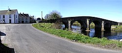
|picture= | |picture=Killeter Bridge - geograph.org.uk - 390225.jpg | ||
|picture caption= | |picture caption= | ||
|os grid ref= | |os grid ref=H240806 | ||
|LG district=Strabane | |latitude=54.6687 | ||
|longitude=-7.6823 | |||
|population=147 | |||
|census year=2001 | |||
|post town=Castlederg | |||
|postcode=BT81 | |||
|dialling code=028 | |||
|townland=yes | |||
|LG district=Derry and Strabane | |||
|constituency=West Tyrone | |||
|website= | |||
}} | }} | ||
'''Killeter''' is a village in [[Tyrone]]. | '''Killeter''' is a small village and townland near [[Castlederg]] in [[Tyrone]]. The 2001 Census recorded a population of 147. | ||
{{ | This village, plus the rural protrusion of Tyrone to its immediate west, would have been transferred to the Irish Free State had the recommendations of the Irish Boundary Commission been enacted in 1925.<ref>{{cite web|url=http://discovery.nationalarchives.gov.uk/details/r/C386829|title=Irish Boundary Commission Report|publisher=National Archives|date=1925|p=140-43}}</ref> | ||
==About the village== | |||
Near Killeter is the Magherakeel historical site with a holy well, lime kiln and ruins of an early church.<ref>{{cite web | title=Destinations - UK - Ireland| work=Touring Tyrone| url=http://www.destinations-uk.com/ireland.php?countyid=85 | access-date=16 January 2011}}</ref> | |||
Killeter has a yearly August fair, which celebrates the diversity and richness of rural life. The village itself sits along an ancient pilgrimage trail which winds its way to [[Lough Derg, County Donegal|Lough Derg]]. The national cycle network traverses part of this trail, which is bounded to the west by Killeter Forest. | |||
The writer Benedict Kiely has stated that he based the fictional village of Carmincross, in his novel ''Nothing Happens in Carmincross'', on Killeter.<ref>Afterword to ''Proxopera: A Tale of Modern Ireland'' (Godine, 1989)</ref> | |||
On 29 April 1844, a shower of meteoric stones fell, in the sight of several people, at Killeter; they were broken into small fragments and only one piece was found whole. | |||
{{commons}} | |||
==References== | |||
{{reflist}} | |||
Latest revision as of 16:48, 4 December 2022
| Killeter | |
| Tyrone | |
|---|---|

| |
| Location | |
| Grid reference: | H240806 |
| Location: | 54°40’7"N, 7°40’56"W |
| Data | |
| Population: | 147 (2001) |
| Post town: | Castlederg |
| Postcode: | BT81 |
| Dialling code: | 028 |
| Local Government | |
| Council: | Derry and Strabane |
| Parliamentary constituency: |
West Tyrone |
Killeter is a small village and townland near Castlederg in Tyrone. The 2001 Census recorded a population of 147.
This village, plus the rural protrusion of Tyrone to its immediate west, would have been transferred to the Irish Free State had the recommendations of the Irish Boundary Commission been enacted in 1925.[1]
About the village
Near Killeter is the Magherakeel historical site with a holy well, lime kiln and ruins of an early church.[2]
Killeter has a yearly August fair, which celebrates the diversity and richness of rural life. The village itself sits along an ancient pilgrimage trail which winds its way to Lough Derg. The national cycle network traverses part of this trail, which is bounded to the west by Killeter Forest.
The writer Benedict Kiely has stated that he based the fictional village of Carmincross, in his novel Nothing Happens in Carmincross, on Killeter.[3]
On 29 April 1844, a shower of meteoric stones fell, in the sight of several people, at Killeter; they were broken into small fragments and only one piece was found whole.
| ("Wikimedia Commons" has material about Killeter) |
References
- ↑ "Irish Boundary Commission Report". National Archives. 1925. http://discovery.nationalarchives.gov.uk/details/r/C386829.
- ↑ "Destinations - UK - Ireland". Touring Tyrone. http://www.destinations-uk.com/ireland.php?countyid=85.
- ↑ Afterword to Proxopera: A Tale of Modern Ireland (Godine, 1989)
