Cromwell, Nottinghamshire: Difference between revisions
Created page with '{{Infobox town |name=Cromwell |county=Nottinghamshire |picture= |picture caption= |os grid ref=SK798614 |latitude=53.14 |longitude=-0.81 |population=188 |post town=Newark |postco…' |
m clean up, typos fixed: a 13th century → a 13th-century, so called → so-called |
||
| (3 intermediate revisions by 2 users not shown) | |||
| Line 2: | Line 2: | ||
|name=Cromwell | |name=Cromwell | ||
|county=Nottinghamshire | |county=Nottinghamshire | ||
|picture= | |picture=St Giles, Cromwell Geograph-2166369-by-nick-macneill.jpg | ||
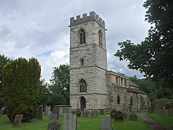
|picture caption= | |picture caption=St Giles, Cromwell | ||
|os grid ref=SK798614 | |os grid ref=SK798614 | ||
|latitude=53.14 | |latitude=53.14 | ||
| Line 14: | Line 14: | ||
|constituency= | |constituency= | ||
}} | }} | ||
'''Cromwell''' is a village in [[Nottinghamshire]], found | '''Cromwell''' is a village in [[Nottinghamshire]], found five miles north of [[Newark on Trent]]. | ||
The parish church is St Giles' Church, a 13th century building, with a tower built around 1427. | The parish church is St Giles' Church, a 13th-century building, with a tower built around 1427. | ||
The Old Rectory was built in about 1680 as a dower house for the Earl of Clare, and in use as a rectory before 1714. Between the village and the River Trent lies an extensive area of Roman fields within which stood a villa. Parts of a timber and stone bridge have also been recorded close by.<ref>Pevsner, Nikolaus. 1979. ''The Buildings of England: Nottinghamshire''. pp 108-109. Harmondsworth, Middx. Penguin.</ref> | The Old Rectory was built in about 1680 as a dower house for the Earl of Clare, and in use as a rectory before 1714. Between the village and the River Trent lies an extensive area of Roman fields within which stood a villa. Parts of a timber and stone bridge have also been recorded close by.<ref>Pevsner, Nikolaus. 1979. ''The Buildings of England: Nottinghamshire''. pp 108-109. Harmondsworth, Middx. Penguin.</ref> | ||
Cromwell is one of the four [[Thankful Villages]] in Nottinghamshire - those rare places that suffered no fatalities during the Great War of 1914 to 1918. | Cromwell is one of the four [[Thankful Villages]] in Nottinghamshire - those rare places that suffered no fatalities during the Great War of 1914 to 1918. | ||
Just to the east of the village is Cromwell Lock the point where the non tidal River Trent ends and the so called Tideway starts. From Cromwell lock commercial traffic and pleasure craft may navigate north towards Torksey Gainsborough and ultimately the Trent Falls where the [[River Trent]] meets the [[River Ouse, Yorkshire|Yorkshire Ouse]] and becomes the [[Humber]]. Navigators on the Trent must wait till the tide is ebbing or flooding in their favour to ensure a safe and efficient passage. | Just to the east of the village is Cromwell Lock the point where the non tidal River Trent ends and the so-called Tideway starts. From Cromwell lock commercial traffic and pleasure craft may navigate north towards Torksey Gainsborough and ultimately the Trent Falls where the [[River Trent]] meets the [[River Ouse, Yorkshire|Yorkshire Ouse]] and becomes the [[Humber]]. Navigators on the Trent must wait till the tide is ebbing or flooding in their favour to ensure a safe and efficient passage. | ||
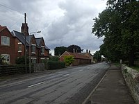
[[File:Cromwell, the old A1 or Great North Road, Nottinghamshire - geograph.org.uk - 1412966.jpg|left|200px|The Old North Road in Cromwell]] | |||
==Outside links== | ==Outside links== | ||
Latest revision as of 19:31, 28 January 2016
| Cromwell | |
| Nottinghamshire | |
|---|---|
 St Giles, Cromwell | |
| Location | |
| Grid reference: | SK798614 |
| Location: | 53°8’24"N, -0°48’36"W |
| Data | |
| Population: | 188 |
| Post town: | Newark |
| Postcode: | NG23 |
| Local Government | |
| Council: | Newark and Sherwood |
Cromwell is a village in Nottinghamshire, found five miles north of Newark on Trent.
The parish church is St Giles' Church, a 13th-century building, with a tower built around 1427.
The Old Rectory was built in about 1680 as a dower house for the Earl of Clare, and in use as a rectory before 1714. Between the village and the River Trent lies an extensive area of Roman fields within which stood a villa. Parts of a timber and stone bridge have also been recorded close by.[1]
Cromwell is one of the four Thankful Villages in Nottinghamshire - those rare places that suffered no fatalities during the Great War of 1914 to 1918.
Just to the east of the village is Cromwell Lock the point where the non tidal River Trent ends and the so-called Tideway starts. From Cromwell lock commercial traffic and pleasure craft may navigate north towards Torksey Gainsborough and ultimately the Trent Falls where the River Trent meets the Yorkshire Ouse and becomes the Humber. Navigators on the Trent must wait till the tide is ebbing or flooding in their favour to ensure a safe and efficient passage.

Outside links
| ("Wikimedia Commons" has material about Cromwell, Nottinghamshire) |
References
- ↑ Pevsner, Nikolaus. 1979. The Buildings of England: Nottinghamshire. pp 108-109. Harmondsworth, Middx. Penguin.

This Nottinghamshire article is a stub: help to improve Wikishire by building it up.
