Strethall: Difference between revisions
Jump to navigation
Jump to search
Created page with '{{Infobox town |name=Strethall |county=Essex |os grid ref=TL491394 |postcode=CB11 |latitude=52.033135 |longitude=0.172852 |LG district=Uttlesford }} '''Strethall''' is a small vi…' |
mNo edit summary |
||
| Line 2: | Line 2: | ||
|name=Strethall | |name=Strethall | ||
|county=Essex | |county=Essex | ||
|picture=St. Mary's church, Strethall, Essex - geograph.org.uk - 208275.jpg | |||
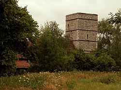
|picture caption=St Mary's, Strethall | |||
|os grid ref=TL491394 | |os grid ref=TL491394 | ||
|postcode=CB11 | |postcode=CB11 | ||
Latest revision as of 21:56, 9 November 2012
| Strethall | |
| Essex | |
|---|---|
 St Mary's, Strethall | |
| Location | |
| Grid reference: | TL491394 |
| Location: | 52°1’59"N, -0°10’22"E |
| Data | |
| Postcode: | CB11 |
| Local Government | |
| Council: | Uttlesford |
Strethall is a small village in Essex, near the town of Saffron Walden. It is a somewhat disjointed village of two clusters of houses joined only by a footpath or a diversion out of the village. The parish church is attached to the hall at the north of the village.
Littlebury Green lies to the south.
Strethall is one of the Thankful Villages, which is to say one of the few villages which suffered no losses amongst its menfolk in the First World War. It is the only such village in the county.

This Essex article is a stub: help to improve Wikishire by building it up.