Manor Hills: Difference between revisions
Jump to navigation
Jump to search
Created page with 'right|thumb|300px|Dollar Law to the Manor Water The '''Manor Hills''' are a range of hills on the borders of [[…' |
mNo edit summary |
||
| (2 intermediate revisions by 2 users not shown) | |||
| Line 1: | Line 1: | ||
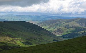
[[File:Manor Water from Dollar Law - geograph.org.uk - 16230.jpg|right|thumb|300px|Dollar Law to the Manor Water]] | [[File:Manor Water from Dollar Law - geograph.org.uk - 16230.jpg|right|thumb|300px|Dollar Law to the Manor Water]] | ||
The '''Manor Hills''' are a range of hills on the borders of [[Peeblesshire]] and [[Selkirkshire]], to the south of the [[River Tweed|Tweed Valley]]. The | The '''Manor Hills''' are a range of hills on the borders of [[Peeblesshire]] and [[Selkirkshire]], to the south of the [[River Tweed|Tweed Valley]]. The highest hill amongst them is [[Broad Law]], which is the second-highest of the Southern Uplands. | ||
The [[Manor Water]] flows through the middle of the range, northwards down to the [[River Tweed]]. | The [[Manor Water]] flows through the middle of the range, northwards down to the [[River Tweed]]. | ||
| Line 10: | Line 10: | ||
! width="30%"|Fell !! Height (feet) !! Height (m) !! width="20%"|County !! Grid reference | ! width="30%"|Fell !! Height (feet) !! Height (m) !! width="20%"|County !! Grid reference | ||
|- | |- | ||
| [[Broad Law]] | | [[Broad Law]] || {{commas|2756}} || 840 || [[Peeblesshire]] || {{getmapecho|NT146235}} | ||
|- | |- | ||
| [[Cramalt Craig]] || {{commas|2726}} || 831 || || {{getmapecho|NT168247}} | | [[Cramalt Craig]] || {{commas|2726}} || 831 || || {{getmapecho|NT168247}} | ||
| Line 30: | Line 30: | ||
| [[Middle Hill]] || {{commas|2349}} || 716 || || {{getmapecho|NT159294}} | | [[Middle Hill]] || {{commas|2349}} || 716 || || {{getmapecho|NT159294}} | ||
|- | |- | ||
| [[Black Law]] || {{commas|2290}} || 698 || [[Selkirkshire]] /<br>[[Peeblesshire]] || {{getmapecho|NT222279}} | | [[Black Law, Selkirkshire|Black Law]] || {{commas|2290}} || 698 || [[Selkirkshire]] /<br>[[Peeblesshire]] || {{getmapecho|NT222279}} | ||
|- | |- | ||
| [[Talla Cleuch Head]] || {{commas|2267}} || 691 || || {{getmapecho|NT133218}} | | [[Talla Cleuch Head]] || {{commas|2267}} || 691 || || {{getmapecho|NT133218}} | ||
Latest revision as of 21:41, 5 February 2017

The Manor Hills are a range of hills on the borders of Peeblesshire and Selkirkshire, to the south of the Tweed Valley. The highest hill amongst them is Broad Law, which is the second-highest of the Southern Uplands.
The Manor Water flows through the middle of the range, northwards down to the River Tweed.
The mountains of the Manor Hills over 2,000 feet are:
| Fell | Height (feet) | Height (m) | County | Grid reference |
|---|---|---|---|---|
| Broad Law | 2756 | 840 | Peeblesshire | NT146235 |
| Cramalt Craig | 2726 | 831 | NT168247 | |
| Dollar Law | 2680 | 817 | Peeblesshire | NT178278 |
| Fifescar Knowe | 2661 | 811 | NT175270 | |
| Dun Rig | 2441 | 744 | Selkirkshire / Peeblesshire |
NT253315 |
| Pykestone Hill | 2418 | 737 | NT173312 | |
| Notman Law | 2408 | 734 | NT185260 | |
| Glenrath Heights | 2402 | 732 | NT241322 | |
| The Scrape | 2359 | 719 | NT176324 | |
| Middle Hill | 2349 | 716 | NT159294 | |
| Black Law | 2290 | 698 | Selkirkshire / Peeblesshire |
NT222279 |
| Talla Cleuch Head | 2267 | 691 | NT133218 | |
| Stob Law | 2218 | 676 | NT230332 | |
| Black Cleuch Hill (Blackhouse Heights) |
2215 | 675 | Selkirkshire / Peeblesshire |
NT222290 |
| Drumelzier Law | 2192 | 668 | NT149312 | |
| Birkscairn Hill | 2169 | 661 | NT274331 | |
| Greenside Law | 2110 | 643 | NT198256 | |
| Clockmore | 2103 | 641 | NT183228 | |
| Hunt Law | 2096 | 639 | NT150264 | |
| Taberon Law | 2087 | 636 | NT146288 | |
| Deer Law | 2064 | 629 | NT222255 | |
| Conscleuch Head | 2047 | 624 | NT220262 |