Uppingham: Difference between revisions
Jump to navigation
Jump to search
Created page with '{{Infobox town | name=Uppingham | county=Rutland | latitude=52.5900 | longitude=-0.7222 | picture=Market Place, Uppingham, Rutland - geograph.org.uk - 45132.jpg | picture caption…' |
mNo edit summary |
||
| Line 14: | Line 14: | ||
| os grid ref=SP865999 | | os grid ref=SP865999 | ||
}} | }} | ||
'''Uppingham''' is a small market town in [[Rutland]], six miles south of the county town, [[Oakham]]. It is the home of a public school, Uppingham School. | |||
'''Uppingham''' is a small market town in [[Rutland]], | |||
The parish church, the Church of St Peter and St Paul, dates largely from the 14th century. | The parish church, the Church of St Peter and St Paul, dates largely from the 14th century. | ||
Latest revision as of 11:11, 1 September 2010
| Uppingham | |
| Rutland | |
|---|---|
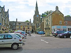
 Market Place, Uppingham | |
| Location | |
| Grid reference: | SP865999 |
| Location: | 52°35’24"N, -0°43’20"W |
| Data | |
| Population: | 3,781 |
| Post town: | Oakham |
| Postcode: | LE15 |
| Dialling code: | 01572 |
| Local Government | |
| Council: | Rutland |
| Parliamentary constituency: |
Rutland and Melton |
Uppingham is a small market town in Rutland, six miles south of the county town, Oakham. It is the home of a public school, Uppingham School.
The parish church, the Church of St Peter and St Paul, dates largely from the 14th century.
Uppingham Workhouse
Uppingham Workhouse was first recorded in 1777 with space for 40 inmates. Until 1834 it was a parish workhouse, but in 1836 the Uppingham Poor Law Union began, and a new Union workhouse was built on Leicester Road to house 158 people to a design by architect William Donthorne. In the Great War, the building was used as an auxiliary hospital staffed by a Voluntary Aid Detachment. The workhouse was closed in 1929, and taken over by Uppingham School which uses the building as a boarding house.