Hamstall Ridware: Difference between revisions
Jump to navigation
Jump to search
Created page with "{{Infobox town |county=Stafford |picture=St Michael's Church, Hamstall Ridware.jpg |picture caption=Church of St Michael and All Angels |latitude=52.768275 |longitude=-1.84166..." |
(No difference)
|
Latest revision as of 19:57, 28 April 2024
| Hamstall Ridware | |
| Staffordshire | |
|---|---|
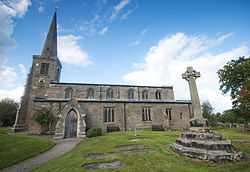
 Church of St Michael and All Angels | |
| Location | |
| Grid reference: | SK107189 |
| Location: | 52°46’6"N, 1°50’30"W |
| Data | |
| Population: | 313 (2011[1]) |
| Post town: | Rugeley |
| Postcode: | WS15 |
| Dialling code: | 01889 |
| Local Government | |
| Council: | Lichfield |
| Parliamentary constituency: |
Lichfield |
Hamstall Ridware is a village and parish in the Offlow Hundred of Staffordshire. It is in the Trent Valley, and lies close to the villages of Hill Ridware, Mavesyn Ridware and Pipe Ridware. It is eight miles north of the city of Lichfield, and four miles east of Rugeley. The hamlet of Olive Green lies to the east of the village at SK116187.
Within the village lie the grade II* listed ruins of Hamstall Hall.[2][3][4]
References
- ↑ "Civil Parish population 2011". Neighbourhood Statistics. Office for National Statistics. http://www.neighbourhood.statistics.gov.uk/dissemination/LeadKeyFigures.do?a=7&b=11124185&c=Hamstall+Ridware&d=16&e=62&g=6463651&i=1001x1003x1032x1004&m=0&r=1&s=1449589494281&enc=1.
- ↑ National Heritage List 1038777: HAMSTALL HALL
- ↑ National Heritage List 1190607: GATEHOUSE AND ATTACHED COURTYARD WALLS AT HAMSTALL HALL
- ↑ National Heritage List 1374300: TOWER AND ATTACHED WALLS AT HAMSTALL HALL
Outside links
| ("Wikimedia Commons" has material about Ridware Hamstall Ridware) |

This Staffordshire article is a stub: help to improve Wikishire by building it up.
