Tideford: Difference between revisions
mNo edit summary |
No edit summary |
||
| (One intermediate revision by one other user not shown) | |||
| Line 14: | Line 14: | ||
|constituency=South East Cornwall | |constituency=South East Cornwall | ||
}} | }} | ||
'''Tideford''' | '''Tideford''' is a small village in eastern [[Cornwall]]. The first part of the name is pronounced ''TIdder''.<ref>G.M. Miller, ''BBC Pronouncing Dictionary of British Names'' (Oxford UP, 1971), p. 148.</ref> The name derives from its location on the [[River Tiddy]]. | ||
The | |||
Tideford is not listed in the [[Domesday Book]] but the earliest settlement is thought to have been around 1100AD. The bridge over the [[River Tiddy]] at the bottom of Bridge Road dates from the 14th century and this is the earliest surviving structure. | Tideford is not listed in the [[Domesday Book]] but the earliest settlement is thought to have been around 1100AD. The bridge over the [[River Tiddy]] at the bottom of Bridge Road dates from the 14th century and this is the earliest surviving structure. | ||
Latest revision as of 19:23, 13 February 2023
| Tideford | |
| Cornwall | |
|---|---|

| |
| Location | |
| Grid reference: | SX348597 |
| Location: | 50°24’52"N, 4°19’36"W |
| Data | |
| Population: | 325 (2011) |
| Post town: | Saltash |
| Postcode: | PL12 |
| Dialling code: | 01752 |
| Local Government | |
| Parliamentary constituency: |
South East Cornwall |
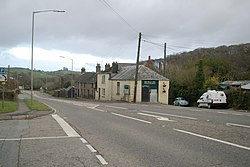
Tideford is a small village in eastern Cornwall. The first part of the name is pronounced TIdder.[1] The name derives from its location on the River Tiddy.
Tideford is not listed in the Domesday Book but the earliest settlement is thought to have been around 1100AD. The bridge over the River Tiddy at the bottom of Bridge Road dates from the 14th century and this is the earliest surviving structure.
Tideford grew in the eighteenth century as the nearby Port Eliot country estate built a number of houses in the village. Many of these have now been sold, but of note is 'Bridge House', located at the bottom of Bridge Road, which remains a gatehouse onto the estate.
The village is on the busy A38 between Saltash and Liskeard, the southerly of two main arterial road routes through Cornwall. Tideford does not have a railway station, the nearest being at St Germans, some two miles south.
The village has a butchers' shop, a Post Office, a branch of the Royal British Legion, a Montessori nursery, an abattoir and a small public house.
Churches
The Victorian church of St Luke was designed by renowned architect George Wightwick. The building was originally erected as a chapel-of-ease in St Germans parish and was consecrated on 31 July 1845, consisting of a chancel, nave and gable-cote containing two bells. The church is fitted with oak seats and contains a pulpit. The registers date from 1845.
Tideford is now part of the united parishes of St Germans, Hessenford, Downderry and Tideford.
The small Wesleyan Methodist chapel was built in 1838 and there was also a Reformed Methodist chapel.
There was also once a Society of Friends' (Quakers') Meeting house and attached Burial Ground in Tideford.[2]
Outside links
| ("Wikimedia Commons" has material about Tideford) |
