Drumnakilly: Difference between revisions
Jump to navigation
Jump to search
Created page with '{{Infobox town |name=Drumnakilly |county=Tyrone |picture= |picture caption= |os grid ref=H5373 |LG district=Omagh }} '''Drumnakilly''' is a village in Tyrone. {{stub}}' |
No edit summary |
||
| Line 2: | Line 2: | ||
|name=Drumnakilly | |name=Drumnakilly | ||
|county=Tyrone | |county=Tyrone | ||
|picture= | |picture=Junction of Drumnakilly Road and Racolpa Road - geograph.org.uk - 3264758.jpg | ||
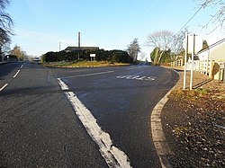
|picture caption= | |picture caption=Road juntion in Drumnakilly | ||
|os grid ref= | |os grid ref= H538732 | ||
|LG district=Omagh | |latitude=54.603888889 | ||
|longitude=-7.168888889 | |||
|population= | |||
|census year= | |||
|post town= | |||
|postcode= | |||
|dialling code=028 | |||
|townland=yes | |||
|LG district=Fermanagh and Omagh | |||
|constituency= | |||
}} | }} | ||
'''Drumnakilly''' is a village in [[Tyrone]]. | '''Drumnakilly''' is a small village and townland between [[Carrickmore]] and [[Omagh]] in [[Tyrone]]. The 2001 Census recorded a population of 114 people. | ||
{{ | The name of the village is from the Gaelic ''Droim na Coille'', meaning 'Ridge of the Wood'.<ref>{{placenamesNI|4739|Drumnakilly}}</ref> The townland is in the Barony of [[Strabane Upper]]. | ||
==References== | |||
{{reflist}} | |||
Latest revision as of 21:22, 1 December 2022
| Drumnakilly | |
| Tyrone | |
|---|---|
 Road juntion in Drumnakilly | |
| Location | |
| Grid reference: | H538732 |
| Location: | 54°36’14"N, 7°10’8"W |
| Data | |
| Dialling code: | 028 |
| Local Government | |
| Council: | Fermanagh and Omagh |
Drumnakilly is a small village and townland between Carrickmore and Omagh in Tyrone. The 2001 Census recorded a population of 114 people.
The name of the village is from the Gaelic Droim na Coille, meaning 'Ridge of the Wood'.[1] The townland is in the Barony of Strabane Upper.
References
- ↑ Drumnakilly - Placenames NI