Difference between revisions of "Wherwell"
(Created page with "{{Infobox town |name=Wherwell |county=Hampshire |picture=Wherwell - geograph.org.uk - 193057.jpg |picture caption=Wherwell |os grid ref=SU389409 |latitude=51.166 |longitude=-...") |
|||
| Line 20: | Line 20: | ||
[[File:Wherwell - Church Street - geograph.org.uk - 1466582.jpg|left|thumb|200px|Church Street]] | [[File:Wherwell - Church Street - geograph.org.uk - 1466582.jpg|left|thumb|200px|Church Street]] | ||
| − | Before the | + | Before the Dissolution of the Monasteries, the parish of Wherwell was in the hands of an important abbey of Benedictine nuns, whose abbess was Lady of the Manor of an area much larger than the existing parish. |
==Parish church== | ==Parish church== | ||
| Line 36: | Line 36: | ||
*[http://www.ChilboltonandWherwell.info Chilbolton and Wherwell Community] | *[http://www.ChilboltonandWherwell.info Chilbolton and Wherwell Community] | ||
*[http://www.downsbenefice.org/index.php?&pg=St_Peter_and_Holy_Cross&album=Wherwell St Peter and Holy Cross Church, Wherwell] | *[http://www.downsbenefice.org/index.php?&pg=St_Peter_and_Holy_Cross&album=Wherwell St Peter and Holy Cross Church, Wherwell] | ||
| − | |||
*[http://www.francisfrith.com/wherwell/ Wherwell photos, maps and memories] | *[http://www.francisfrith.com/wherwell/ Wherwell photos, maps and memories] | ||
*[http://www.chilboltonandwherwell.info/index.php/local-publications2 Publications featuring Wherwell] | *[http://www.chilboltonandwherwell.info/index.php/local-publications2 Publications featuring Wherwell] | ||
| − | |||
==References== | ==References== | ||
{{reflist}} | {{reflist}} | ||
Revision as of 20:43, 7 November 2022
| Wherwell | |
| Hampshire | |
|---|---|
 Wherwell | |
| Location | |
| Grid reference: | SU389409 |
| Location: | 51°9’58"N, 1°26’42"W |
| Data | |
| Population: | 473 (2011, parish) |
| Post town: | Andover |
| Postcode: | SP11 |
| Dialling code: | 01794 |
| Local Government | |
| Council: | Test Valley |
| Parliamentary constituency: |
Romsey and Southampton North |
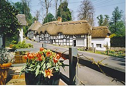
Wherwell is a village on the River Test in the midst of Hampshire. It gives its name to the county's Wherwell Hundred.
The name of the village may derive from its bubbling springs. The name is recorded om 955 as “Hwerwyl”, possibly meaning “kettle springs” or “cauldron springs.” Pronunciation of the name has ranged from “Hurrell” to “Wer-rel” to present-day “Wher-well.”
Before the Dissolution of the Monasteries, the parish of Wherwell was in the hands of an important abbey of Benedictine nuns, whose abbess was Lady of the Manor of an area much larger than the existing parish.
Parish church
The parish church, St Peter and Holy Cross was restored in 1856-8. It is a double-aisled medieval building, which may have been part of the adjoining Benedictine Nunnery.
The church is a Grade II* listed building.[1]
Local legend
The town is associated with a legendary cockatrice; a fearsome, venomous beast.
The story is that the cockatrice terrorised the village until it was imprisoned in the dungeons below Wherwell Priory. A prize of land was offered to anyone who could kill the creature. None were successful, until a man named Green lowered a mirror into the dungeon. The cockatrice battled against its own reflection until exhausted, at which point Green was able to kill it. Today there is an area of land near Wherwell called Green's Acres. For many years a weather vane in the shape of a cockatrice adorned the parish church until it was removed to Andover Museum.
Outside links
| ("Wikimedia Commons" has material about Wherwell) |
- Chilbolton and Wherwell Community
- St Peter and Holy Cross Church, Wherwell
- Wherwell photos, maps and memories
- Publications featuring Wherwell
References
- ↑ National Heritage List 1179499: Church of St Peter and Holy Cross (Grade II* listing)
