Croxton, Norfolk: Difference between revisions
Jump to navigation
Jump to search
Created page with "{{Infobox town |name=Croxton |county=Norfolk |picture=Croxton-g4.jpg |picture caption=Croxton All Saints |os grid ref=TL876865 |latitude=52.445 |longitude=0.76 |population=44..." |
|||
| Line 26: | Line 26: | ||
==References== | ==References== | ||
{{reflist}} | {{reflist}} | ||
*[http://www.heritage.norfolk.gov.uk/record-details?MNF5743-All-Saints%27-Church-Croxton&Index=5361&RecordCount=56881&SessionID=a77f6802-735d-4e40-a070-56d024f3ae68 All Saints' Church, Croxton]: Norfolk Heritage Explorer | |||
Latest revision as of 22:37, 27 November 2020
| Croxton | |
| Norfolk | |
|---|---|
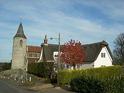
 Croxton All Saints | |
| Location | |
| Grid reference: | TL876865 |
| Location: | 52°26’42"N, 0°45’36"E |
| Data | |
| Population: | 445 (2011) |
| Post town: | Thetford |
| Postcode: | IP24 |
| Local Government | |
| Council: | Breckland |
Croxton is a village in Norfolk, standing just to the north of the border town of Thetford. The parish had a recorded population of 445 at the 2011 census, in 187 households.
All Saints Church
The village church, All Saints, is one of 124 existing round-tower churches in Norfolk. The tower and priest's door are late 12th century, but most of the rest of the structure is of about 1300. The first recorded Parish Priest was Simon Peche, in 1316.[1]
Outside links
| ("Wikimedia Commons" has material about Croxton, Norfolk) |
- Website with photos of Croxton All Saints: Round Tower Churches
References
- ↑ All Saints, Croxton: Norfolk Churches
- All Saints' Church, Croxton: Norfolk Heritage Explorer
