Deopham: Difference between revisions
Jump to navigation
Jump to search
Edited Deopham |
m Grid ref, Lat & Long |
||
| Line 3: | Line 3: | ||
|county=Norfolk | |county=Norfolk | ||
|picture=St Andrew's Church, Deopham, Norfolk - geograph.org.uk - 806068.jpg | |picture=St Andrew's Church, Deopham, Norfolk - geograph.org.uk - 806068.jpg | ||
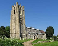
|picture caption= | |picture caption=St Andrew's Church, Deopham | ||
|os grid ref= | |os grid ref=TG051008 | ||
|latitude= | |latitude=52.566738 | ||
|longitude= | |longitude=1.0248184 | ||
|population=541 | |population=541 | ||
|postcode=NR18 | |postcode=NR18 | ||
Latest revision as of 11:18, 30 September 2020
| Deopham | |
| Norfolk | |
|---|---|
 St Andrew's Church, Deopham | |
| Location | |
| Grid reference: | TG051008 |
| Location: | 52°34’0"N, 1°1’29"E |
| Data | |
| Population: | 541 |
| Post town: | Wymondham |
| Postcode: | NR18 |
| Dialling code: | 01953 |
| Local Government | |
Deopham is a village in the south of the county of Norfolk. The tower of its parish church is one of the tallest in Norfolk.