Gwithian: Difference between revisions
Created page with "{{Infobox town |name=Gwithian |cornish=Godhyan |county=Cornwall |picture=Gwithian Parish Church.jpg |picture caption=St Gothian's Church, Gwithian |os grid ref=SW585412 |l..." |
No edit summary |
||
| Line 16: | Line 16: | ||
|dialling code=01736 | |dialling code=01736 | ||
}} | }} | ||
'''Gwithian''' is a coastal village in western [[Cornwall]], three miles | '''Gwithian''' is a coastal village in western [[Cornwall]], three miles north-east of [[Hayle]] and four miles east of [[St Ives, Cornwall|St Ives]] across [[St Ives Bay]]. It is close by [[Gwinear]], with which it shares a civil parish ('Gwinear-Gwithian'). | ||
Gwithian has a pub, the Red River Inn, which was formerly named the Pendarves Arms. The pub takes its name from the nearby [[Red River, Cornwall|Red River]] which, in turn, got its name from the discolouration caused by mining effluent. The river's earlier name was Dowr Coner. | Gwithian has a pub, the Red River Inn, which was formerly named the Pendarves Arms. The pub takes its name from the nearby [[Red River, Cornwall|Red River]] which, in turn, got its name from the discolouration caused by mining effluent. The river's earlier name was Dowr Coner. | ||
| Line 29: | Line 29: | ||
The [[Penwith Hundred|Hundred of Penwith]] had its ancient centre at '''Connerton''', now buried beneath the sands of Gwithian Towans. The institutions of the hundred were moved to Penzance in 1771 (or earlier) following large successive inundations of in blown sand. In the Geld Inquest of 1083, only seven hundreds are found in Cornwall, identified by the names of the chief manors of each: Connerton, Winnianton, Pawton, Tybesta, Stratton, Fawton and Rillaton (corresponding to Penwith, Kerrier, Pydar, Powder, Trigg, West Wivel and East Wivel). Connerton was held at the time of the [[Domesday Book|Domesday Survey]] by King William and had been held by Brictric and then by Queen Matilda before him. In 1086 there was land for 40 ploughs and 30 villagers, 20 smallholders and 30 serfs are recorded. There was a mill, 300 sheep, 40 wild mares and 21 other animals.<ref>Thorn, Caroline & Frank, eds. (1979) ''Domesday Book. 10: Cornwall''. Chichester: Phillimore; entry 1,13-14</ref> | The [[Penwith Hundred|Hundred of Penwith]] had its ancient centre at '''Connerton''', now buried beneath the sands of Gwithian Towans. The institutions of the hundred were moved to Penzance in 1771 (or earlier) following large successive inundations of in blown sand. In the Geld Inquest of 1083, only seven hundreds are found in Cornwall, identified by the names of the chief manors of each: Connerton, Winnianton, Pawton, Tybesta, Stratton, Fawton and Rillaton (corresponding to Penwith, Kerrier, Pydar, Powder, Trigg, West Wivel and East Wivel). Connerton was held at the time of the [[Domesday Book|Domesday Survey]] by King William and had been held by Brictric and then by Queen Matilda before him. In 1086 there was land for 40 ploughs and 30 villagers, 20 smallholders and 30 serfs are recorded. There was a mill, 300 sheep, 40 wild mares and 21 other animals.<ref>Thorn, Caroline & Frank, eds. (1979) ''Domesday Book. 10: Cornwall''. Chichester: Phillimore; entry 1,13-14</ref> | ||
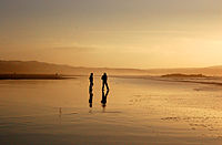
[[File:Evening on Gwithian beach with Ceres Rock in the middle distance - geograph.org.uk - 1707360.jpg|right|thumb|200px|Evening on Gwithian beach looking out to Ceres Rock]] | [[File:Evening on Gwithian beach with Ceres Rock in the middle distance - geograph.org.uk - 1707360.jpg|right|thumb|200px|Evening on Gwithian beach looking out to Ceres Rock]] | ||
Latest revision as of 08:17, 14 September 2020
| Gwithian Cornish: Godhyan | |
| Cornwall | |
|---|---|
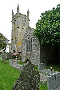
 St Gothian's Church, Gwithian | |
| Location | |
| Grid reference: | SW585412 |
| Location: | 50°13’17"N, 5°23’11"W |
| Data | |
| Population: | 3,032 (2001, parish with Gwinear) |
| Post town: | Hayle |
| Postcode: | TR27 |
| Dialling code: | 01736 |
| Local Government | |
| Council: | Cornwall |
| Parliamentary constituency: |
Camborne and Redruth |
Gwithian is a coastal village in western Cornwall, three miles north-east of Hayle and four miles east of St Ives across St Ives Bay. It is close by Gwinear, with which it shares a civil parish ('Gwinear-Gwithian').
Gwithian has a pub, the Red River Inn, which was formerly named the Pendarves Arms. The pub takes its name from the nearby Red River which, in turn, got its name from the discolouration caused by mining effluent. The river's earlier name was Dowr Coner.
History
Gwithian Towans cover the site of a Bronze Age farm which has been excavated although no remains are visible. The church and relics of St Gwithian or Gocianus, built in 490, were uncovered from the beach and dunes during the early part of the 19th century, but were then allowed to be reclaimed by the shifting sands. Gwithian said hereabouts to be the patron saint of good fortune on the sea.
Charles Henderson wrote in 1925 that the "oratory ... is more perfect than the Oratory at Perran, having been less meddled with, though it is probably not so ancient". According to H. O'Neill Hencken there is the "remains of church, possibly early, buried in sand".[1]
According to tradition there was in the sandy waste between the village and the sea a city of Connor. From Norman times there was a manor here called Connerton which was the paramount manor of the hundred of Penwith. The lords of the manor were bailiffs of the hundred and they held courts and enjoyed the rights of wreck for the coast between Porthtowan and Prussia Cove at least so late as 1580. The importance of this manor may have derived from it being the seat of a Celtic prince in early times.[2] The current church was established further inland in the 15th century but only a few fragments of this building remain incorporated in the lychgate of Edmund Sedding's church of 1866 (the tower however is the original one of the 15th century.)
The Hundred of Penwith had its ancient centre at Connerton, now buried beneath the sands of Gwithian Towans. The institutions of the hundred were moved to Penzance in 1771 (or earlier) following large successive inundations of in blown sand. In the Geld Inquest of 1083, only seven hundreds are found in Cornwall, identified by the names of the chief manors of each: Connerton, Winnianton, Pawton, Tybesta, Stratton, Fawton and Rillaton (corresponding to Penwith, Kerrier, Pydar, Powder, Trigg, West Wivel and East Wivel). Connerton was held at the time of the Domesday Survey by King William and had been held by Brictric and then by Queen Matilda before him. In 1086 there was land for 40 ploughs and 30 villagers, 20 smallholders and 30 serfs are recorded. There was a mill, 300 sheep, 40 wild mares and 21 other animals.[3]

Chesten Marchant, who died in 1676 at Gwithian, is believed to have been the last monoglot Cornish speaker, which is to say the last who spoke Cornish only: the more famous Dolly Pentreath of Paul could speak English also, if reluctantly.
Tourism
A short distance to the east of the village is Gwithian Towans, which is an area of coastal duneland that forms part of The Towans. Gwithian Beach stretches three miles from the Hayle River mouth to the Red River mouth at Godrevy. The beach is popular throughout the year with surfers, windsurfers, and other beachsport enthusiasts. Gwithian beach is patrolled by RNLI lifeguards from Easter to September.
References
- ↑ Hencken, H. O. (1932) The Archaeology of Cornwall and Scilly. London: Methuen; p. 298 (citing Henderson Cornish Church Guide, 1925, p. 107; and PP. 261-2)
- ↑ Cornish Church Guide (1925) Truro: Blackford; p. 107
- ↑ Thorn, Caroline & Frank, eds. (1979) Domesday Book. 10: Cornwall. Chichester: Phillimore; entry 1,13-14