Bermuda: Difference between revisions
No edit summary |
|||
| Line 3: | Line 3: | ||
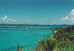
|picture=Bermuda Causeway.jpg | |picture=Bermuda Causeway.jpg | ||
|picture caption=The Causeway | |picture caption=The Causeway | ||
|flag= Flag of Bermuda.svg | |flag=Flag of Bermuda.svg | ||
|arms=Coat_of_arms_of_Bermuda.svg | |arms=Coat_of_arms_of_Bermuda.svg | ||
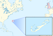
|map | |map=Bermuda location detail.svg | ||
|motto=Quo Fata Ferunt | |motto=Quo Fata Ferunt | ||
|latitude= 32.3 | |latitude= 32.3 | ||
Latest revision as of 23:39, 5 April 2020
| Bermuda (British overseas territory) | |
 The Causeway | |
|---|---|

| |

| |
| Quo Fata Ferunt | |
| Population: | 67,837 (2009 est) |
| Capital: | Hamilton |
| Time zone: | GMT -4 |
| Dialling code: | 1441 |
| TLD: | .bm |
Bermuda (otherwise known as the Bermudas or Somers Islands) is a British overseas territory in the North Atlantic Ocean consisting of one main island and . Its closest continent is North America; the nearest continental land is Cape Hatteras in North Carolina, about 640 miles to the west-northwest, and it is about 850 miles south of Halifax in Nova Scotia. The territory's capital is Hamilton, though its original capital, St George's, remains the larger town.
Bermuda is the oldest and most populous remaining British overseas territory; the first colony was planted in 1605 by Sir George Somers when his expedition to Virginia was shipwrecked here. St George's was settled in 1612.
Bermuda today has an affluent economy, with finance as its largest sector followed by tourism.
Geography

Bermuda lies in the North Atlantic Ocean, near the western edge of the Sargasso Sea, in the open ocean. It has 64 miles of coastline.
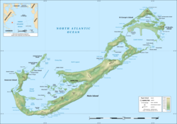
Although usually referred to in the singular, the territory consists of 181 islands, with a total area of 20.6 sq miles. The largest island, Main Island, is sometimes itself called Bermuda. A list of the islands would be complicated; many and island has alternative names and some place names are repeated; there are, for example, two islands named Long Island.
Bermuda has a subtropical climate.[1] It is very susceptible to hurricanes. Its position along the Gulf Stream means that it is often directly in the path of hurricanes in the westerlies, although they have usually begun to weaken as they approach the island. It is often affected by these hurricanes, although the island's small size means that direct landfalls are rare. The last hurricane to cause significant damage to the islands was on 5 September 2003.
The only source of fresh water in Bermuda is rainfall, which is collected on roofs and catchments (or drawn from underground lenses) and stored in tanks. Each dwelling usually has at least one of these tanks forming part of its foundation.
Bermuda has two incorporated municipalities; the City of Hamilton and the Town of St George ("St George's"). Bermuda is divided into parishes.
Parishes and municipalities

Bermuda is divided into nine parishes and two municipalities.
Bermuda's nine parishes:
- Devonshire
- Hamilton
- Paget
- Pembroke
- St George's (St George's & St David's Islands, part of Main Island et al)
- Sandys (Somerset, Ireland & Boaz Islands, part of Main Island et al)
- Smith's
- Southampton
- Warwick
Bermuda's two incorporated municipalities:
- Hamilton (within Pembroke Parish)
- St George's (within St George's Parish)
Bermuda's two informal villages:
History
Pre-settlement
Bermuda was discovered in 1505 by Spanish explorer Juan de Bermúdez.[2] It is mentioned in Legatio Babylonica, published in 1511 by historian Pedro Mártir de Anglería, and was also included on Spanish charts of that year. Both Spanish and Portuguese ships used the islands as a replenishment spot for fresh meat and water, but legends of spirits and devils, now thought to have stemmed only from the callings of raucous birds (most likely the Bermuda Petrel, or Cahow), also the loud noise heard at night from wild hogs and of perpetual, storm-wracked conditions (most early visitors arrived under such conditions) and a surrounding ring of treacherous reefs kept them from attempting any permanent settlement on the Isle of Devils.
A sixteenth century Portuguese ship on the way home from Santo Domingo wedged itself between two rocks on the reef. The crew tried to salvage as much as they could and spent the next four months building a new hull from Bermuda cedar to return to their initial departure point.
English settlement

For a hundred years after its fleeting discovery, Bermuda is believed to have been visited frequently but not permanently settled. Its colonisation can be traced to the efforts of King James I and VI to colonise Virginia after two previous failures. The King granted a Royal Charter to the Virginia Company and in 1609, a company fleet left England under Sir George Somers, and the newly appointed Governor of Jamestown, Sir Thomas Gates, to relieve the colony two years before. The flotilla was broken up by a storm, and the flagship, the Sea Venture, was wrecked off Bermuda; an incident depicted on the territory's arms. The survivors, Somers included, were left in possession of a new territory, named the Somers Islands, which remains an official name for Bermuda. William Shakespeare's play The Tempest is thought to have been inspired by William Strachey's account of this shipwreck.[3]
The island was claimed for the English Crown, and the charter of the Virginia Company was extended to include it. St George's was settled in 1612 and made Bermuda's first capital, and vies with Jamestown for the title of the oldest continually inhabited town in the English-speaking New World. In 1615, the colony was transferred from the Virginia Company to the Somers Isles Company, formed by the same shareholders.
Company colony
Because of its limited land area, Bermuda has had difficulty with over-population. In the first two centuries of settlement it relied on steady human emigration to keep the population manageable. It is often claimed that, before the American Revolution more than ten thousand Bermudians (over half of the population) emigrated, primarily to the American South, where Great Britain was displacing Spain as the dominant European imperial power. A steady trickle of outward migration continued. With seafaring being the only real industry, by the end of the 18th century at least a third of the island's manpower was at sea at any one time.
The archipelago's limited land area and resources led to the creation of what may be the earliest conservation laws of the New World. In 1616 and 1620 acts were passed banning the hunting of certain birds and young tortoises.[4]
In 1649, the end of the English Civil War and the death of King Charles I began a Bermudian civil war, which was ended by militias. This created a strong sense of devotion to the crown for the majority of colonists and it forced those who would not swear allegiance, such as Puritans and independents, into exile in the Bahamas.[5]
In the 17th century the Somers Isles Company suppressed shipbuilding, as it needed Bermudians to farm in order to generate income from the land. Agricultural production met with only limited success, however. The colony of Virginia far surpassed Bermuda in both quality and quantity of tobacco produced. Bermudians began to turn to maritime trades relatively early in the 17th century, but the Somers Isles Company used all its authority to suppress turning away from agriculture. This interference led to the islanders demanding, and receiving, the revocation of the Company's charter in 1684; the Company itself being dissolved.
Maritime economy
After the dissolution of the Somers Isle Company, Bermudians rapidly abandoned agriculture for shipbuilding, replanting farmland with the native juniper (Juniperus bermudiana, also called Bermuda cedar) trees that grew thickly over the whole island. Establishing effective control over the Turks Islands, Bermudians deforested their landscape to begin the salt trade that would become the world's largest, and remained the cornerstone of Bermuda's economy for the next century.
Bermudian sailors would turn their hands to far more trades than supplying salt, however. Whaling, privateering, and the merchant trade were all pursued vigorously. Vessels would sail the normal shipping routes, but had to engage an enemy vessel no matter the size or strength, and as a result many ships were destroyed. The Bermuda sloop became highly regarded for its speed and manoeuvrability. In fact, it was the Bermuda sloop HMS Pickle, one of the fastest vessels in the Royal Navy, that brought the news of the victory at Trafalgar and the death of Admiral Nelson back to England.
Fortress Bermuda

After the American Revolution, the Royal Navy began improving the harbours and built the large dockyard on Ireland Island, in the west of the chain, as its principal naval base guarding the western Atlantic Ocean shipping lanes. During the War of 1812, the British attacks on Washington and the Chesapeake were planned and launched from Bermuda, the Royal Navy's 'North American Station'. Today, the "Maritime Museum" occupies the Keep of the Royal Naval Dockyard, including the Commissioner's House, and exhibits artefacts of the base's military history.
As a result of Bermuda's proximity to the south-eastern coast of the United States, it was regularly used by Confederate States blockade runners during the American Civil War to evade Union naval vessels and bring desperately needed war goods to the South from Britain. The old Globe Hotel in St George's, which was a centre of intrigue for Confederate agents, is preserved as a museum open to the public.
Twentieth century

In the early 20th century, as modern transport and communication systems developed, Bermuda became a popular destination for wealthy American, Canadian and British tourists arriving by frequent steamship service. In addition tariffs enacted by the United States in 1930 cut Bermuda's once-thriving agricultural export trade off, spurring the overseas territory to develop its tourist industry.
In 1933 the Royal Air Force established a station at Bermuda and operated float planes from the harbour in coordination with the British fleet. Later in the 1930s commercial flights began to come to Bermuda, whether as a main destination or to use the islands as a refuelling stop on transatlantic flights. In 1948, regularly scheduled commercial airline service by land-based aeroplanes began to Kindley Field (now Bermuda International Airport), helping tourism to reach its peak in the 1960s–1970s. By the end of the 20th century, international business had supplanted tourism as the dominant sector of Bermuda's economy.
The Royal Naval Dockyard and the attendant military garrison continued to be an important component of Bermuda's economy until the mid-20th century. In addition to considerable building work, the armed forces needed to source food and other materials from local vendors. Beginning in Second World War, United States military installations also were located in Bermuda.
Armed forces

Bermuda was once known as the Gibraltar of the West. After the American Revolutionary War, Bermuda became the Royal Navy's Western Atlantic headquarters, before which the Bermuda government had maintained militia for the defence of the colony. Once the Royal Navy established a base and dockyard defended by regular soldiers, however, these militias became superfluous and were disbanded following the War of 1812. At the end of the 19th century, the colony did raise volunteer units to form a reserve for the military garrison.
Due to its strategic location in the North Atlantic Ocean, Bermuda was vital to the Allies' war effort during both world wars of the 20th century, serving as a marshalling point for trans-Atlantic convoys, as well as a naval and air base (during the Second World War).
In May 1940, the U.S. requested base rights in Bermuda from the United Kingdom, but British Prime Minister Winston Churchill was initially unwilling to accede to the American request without getting something in return.[6] In September 1940, as part of the Destroyers for Bases Agreement, the United Kingdom granted the US base rights in Bermuda. Bermuda and Newfoundland were not originally included in the agreement, but both were added to it, with no war material received in exchange. However, one of the terms of the agreement was that the airfield the US Army was to build in Bermuda would be used jointly by the US and the UK. Construction began in 1941 of two airbases consisting of 1,400 acres of land, largely reclaimed from the sea. For many years, Bermuda's bases were used by US Air Force transport and refuelling aircraft and by US Navy aircraft patrolling the Atlantic for submarines, first German and, later, Soviet. The principal installation, Kindley Air Force Base on the eastern coast, was transferred to the U.S. Navy in 1970 and redesignated Naval Air Station Bermuda. As a naval air station, the base continued to host both transient and deployed USN and USAF aircraft, as well as transitioning or deployed Royal Air Force and Canadian Forces aircraft.
Although leased for 99 years, US forces withdrew in 1995, as part of the wave of base closures following the end of the Cold War.
Canada, which had operated a war-time naval base, HMCS Somers Isles, on the old Royal Navy base at Convict Bay, St George's, also established a radio-listening post at Daniel's Head, in the West End of the islands during this time.
In the 1950s, after the end of Second World War, the Royal Naval dockyard and the military garrison were closed. A small Royal Navy supply base, HMS Malabar, continued to operate within the dockyard area, supporting transiting Royal Navy ships and submarines until it, too, was closed in 1995, along with the American and Canadian bases.
In both First World War and Second World War, Bermudians served in the British armed forces. After the war, Major-General Glyn Gilbert, Bermuda's highest ranking soldier, was instrumental in developing the Bermuda Regiment. Today, the only military unit remaining in Bermuda is the Bermuda Regiment, an amalgam of the voluntary units originally formed toward the end of the 19th century. Although the Regiment's predecessors were voluntary units, the modern body is formed primarily by conscription in which balloted males are required to serve for three years, two months part time, once they turn eighteen.
Sightseeing and attractions

Bermuda's pink sand beaches and clear, cerulean blue ocean waters are popular with tourists and many of Bermuda's hotels are located along the south shore of the island. In addition to its beaches, there are a number of sightseeing attractions. Historic St George's is a designated World Heritage Site. Scuba divers can explore numerous wrecks and coral reefs in relatively shallow water (typically 30-40 feet in depth) with virtually unlimited visibility. Many nearby reefs are readily accessible from shore by snorkellers, especially at Church Bay.
Bermuda's most popular visitor attraction is the Royal Naval Dockyard, which includes the Bermuda Maritime Museum. Other attractions include the Bermuda Aquarium, Museum and Zoo,[7] Bermuda Underwater Exploration Institute, the Botanical Gardens, lighthouses, and the Crystal Caves with its impressive stalactites and underground saltwater pools.
It is not possible to rent a car on the island; however, visitors can hire scooters for use as private transport, or use public transport.
Picture gallery
-
St George's Town and harbour.
-
Stewart Hall, ca. 1707, in St George's, Bermuda
-
St George's, Bermuda
-
Fort St Catherine
-
Juvenile cedar at Ferry Reach, Bermuda
-
Flatts Village, Bermuda
-
The Causeway
-
South Shore of Bermuda (Sinky Bay)
-
Horseshoe Bay, one of Bermuda's public beaches
-
Warwick Long Bay
-
Gibbs Hill Lighthouse, still in daily use
-
St David's Lighthouse, still in daily use

References
- ↑ Forbes, Keith. "Bermuda Climate and Weather". The Royal Gazette. http://www.bermuda-online.org/climateweather.htm. Retrieved 28 Oct. 2008.
- ↑ Morison, Samuel (1974). The European Discovery of America: The Southern Voyages, 1492-1616. New York: Oxford University Press.
- ↑ Woodward, Hobson A Brave Vessel: The True Tale of the Castaways Who Rescued Jamestown and Inspired Shakespeare's The Tempest. Viking (2009) pp. 191-199.
- ↑ Meggs, Martin - Planner (Information Systems, Department of Planning - "Developing a small Island GIS: the Bermuda Experience," Bermuda.
- ↑ Forbes, Keith: "About Bermuda Online", The Royal Gazette Ltd. Retrieved 22 September 2007.
- ↑ Martin Gilbert, Churchill and America. New York: Simon & Schuster, 2005.
- ↑ "Bermuda Aquarium, Museum and Zoo". Bamz.org. http://www.bamz.org. Retrieved 20 Jun. 2010.
Outside links
- Bermuda Government - official government website
- UK Foreign & Commonwealth Office Profile of Bermuda
- Bermuda from UCB Libraries GovPubs
Miscellanea
- Bermuda Maritime Museum, a maritime museum housed in the historic Dockyard, dedicated to public education and historical, archaeological and heritage research.
- Roots Web: Ships of Bermuda (genealogy resource)
- Home page of the Bermuda National Trust
- Bermuda's role in the War of 1812, chronicles Bermuda's little-known role in the American War of 1812
- US Department of State Post Report for Bermuda.
- The Bermuda Yellow Pages, business and social search site.
- Bermuda Sun, a twice-weekly newspaper.
- The Royal Gazette, a daily newspaper, published since 1828.
- Bernews, an online newspaper, updated multiple times daily.
- Association of Bermuda International Companies.
- The Evangelical Church of Bermuda, founded in 1890 when the first eleven members were baptised at Devonshire Bay
- History s Fun: Jamestown and Bermuda: Virginia Company Colonies
- Hampton Roas.com: The Ties That Bind Jamestown and Bermuda


