Peterstone Wentloog: Difference between revisions
Created page with "{{Infobox town |name=Peterstone |county=Monmouthshire |picture=Peterstone Wentloog (Llanbedr Gwynllwg) Former church of St Peter - geograph.org.uk - 69908.jpg |picture caption..." |
No edit summary |
||
| (One intermediate revision by the same user not shown) | |||
| Line 3: | Line 3: | ||
|county=Monmouthshire | |county=Monmouthshire | ||
|picture=Peterstone Wentloog (Llanbedr Gwynllwg) Former church of St Peter - geograph.org.uk - 69908.jpg | |picture=Peterstone Wentloog (Llanbedr Gwynllwg) Former church of St Peter - geograph.org.uk - 69908.jpg | ||
|picture caption=The former St | |picture caption=The former St Peter's church | ||
|os grid ref=ST268802 | |os grid ref=ST268802 | ||
|latitude=51.51596 | |latitude=51.51596 | ||
| Line 15: | Line 15: | ||
|LG district=Newport | |LG district=Newport | ||
}} | }} | ||
'''Peterstone''' or '''Peterstone Wentlooge''' is a small hamlet to the south west of the city of [[Newport, Monmouthshire|Newport | '''Peterstone''' or '''Peterstone Wentlooge''' is a small hamlet and ancient parish in [[Monmouthshire]], to the south-west of the city of [[Newport, Monmouthshire|Newport]]. It lies six miles to the west of Newport city centre and 7½ miles east of [[Cardiff]] city centre. | ||
== History and amenities == | == History and amenities == | ||
Like most of the settlements on the Wentlooge Level it lies on land reclaimed from the [[Bristol Channel]] [http://www.geograph.org.uk/photo/439574]. Peterstone itself lies right against the sea wall [http://www.geograph.org.uk/photo/441247],[http://www.geograph.org.uk/photo/588016] and [http://www.geograph.org.uk/photo/439601]. | Like most of the settlements on the [[Wentloog Hundred|Wentlooge Level]] it lies on land reclaimed from the [[Bristol Channel]] [http://www.geograph.org.uk/photo/439574]. Peterstone itself lies right against the sea wall [http://www.geograph.org.uk/photo/441247],[http://www.geograph.org.uk/photo/588016] and [http://www.geograph.org.uk/photo/439601]. | ||
The former parish Church (now a house) is dedicated to St | The former parish Church (now a house) is dedicated to St Peter [http://www.geograph.org.uk/photo/69908]. | ||
A local pub is the Six Bells [http://www.geograph.org.uk/photo/441292]. | A local pub is the Six Bells [http://www.geograph.org.uk/photo/441292]. | ||
| Line 27: | Line 27: | ||
== Manor claim 2004 == | == Manor claim 2004 == | ||
The village became the focal point of press attention in 2004 as Mark Roberts had previously bought the Lord of the Manor title and then went to charge villagers excessive fees to cross what had always been used as their own land. Matters were raised in | The village became the focal point of press attention in 2004 as Mark Roberts had previously bought the Lord of the Manor title and then went to charge villagers excessive fees to cross what had always been used as their own land. Matters were raised in Parliament and were debated with a reply on the subject from the Parliamentary Under-Secretary of State for Constitutional Affairs acknowledging 'need for reform of the remnants of feudal and manorial law'.<ref>[http://www.publications.parliament.uk/pa/cm200304/cmhansrd/vo040203/halltext/40203h02.htm Hansard, 3 Feb 2004 : Column 204WH, 3 Feb 2004 : Column 205WH]</ref> | ||
==References== | ==References== | ||
Latest revision as of 18:26, 24 February 2019
| Peterstone | |
| Monmouthshire | |
|---|---|
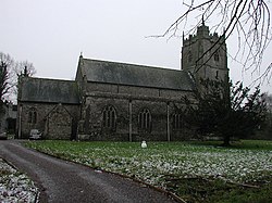
 The former St Peter's church | |
| Location | |
| Grid reference: | ST268802 |
| Location: | 51°30’57"N, 3°3’23"W |
| Data | |
| Post town: | Cardiff |
| Postcode: | CF3 |
| Dialling code: | 01633 |
| Local Government | |
| Council: | Newport |
| Parliamentary constituency: |
Newport West |
Peterstone or Peterstone Wentlooge is a small hamlet and ancient parish in Monmouthshire, to the south-west of the city of Newport. It lies six miles to the west of Newport city centre and 7½ miles east of Cardiff city centre.
History and amenities
Like most of the settlements on the Wentlooge Level it lies on land reclaimed from the Bristol Channel [1]. Peterstone itself lies right against the sea wall [2],[3] and [4].
The former parish Church (now a house) is dedicated to St Peter [5].
A local pub is the Six Bells [6].
Manor claim 2004
The village became the focal point of press attention in 2004 as Mark Roberts had previously bought the Lord of the Manor title and then went to charge villagers excessive fees to cross what had always been used as their own land. Matters were raised in Parliament and were debated with a reply on the subject from the Parliamentary Under-Secretary of State for Constitutional Affairs acknowledging 'need for reform of the remnants of feudal and manorial law'.[1]
References
| ("Wikimedia Commons" has material about Wentloog Peterstone Wentloog) |
