Whitchurch, Warwickshire: Difference between revisions
Created page with "{{Infobox town |name=Whitchurch |county=Warwickshire |picture=Cottages by St. Mary's - geograph.org.uk - 766412.jpg |picture caption=Cottages by St. Mary's Church, Whitchurch..." |
No edit summary |
||
| Line 19: | Line 19: | ||
The parish population at the 2011 census was 174. | The parish population at the 2011 census was 174. | ||
Consisting today of just five properties with a total population (in 2007) of 19, Whitchurch occupies the site of an earlier, larger village which was depopulated in the 15th and 16th centuries as the result of land clearance schemes carried out by the then lords of the manor.<ref>{{brithist|57077|British History on-Line}}</ref> A Norman church survives, now standing alone in the middle of fields, and the mediæval village's fish ponds are still visible today when the river floods. | Consisting today of just five properties with a total population (in 2007) of 19, Whitchurch occupies the site of an earlier, larger village which was depopulated in the 15th and 16th centuries as the result of land clearance schemes carried out by the then lords of the manor.<ref>{{brithist|57077|British History on-Line}}: {{VCH|5}}</ref> A Norman church survives, now standing alone in the middle of fields, and the mediæval village's fish ponds are still visible today when the river floods. | ||
In this southern part of Warwickshire, the county borders are somewhat complex, and while the parish is indeed within Warwickshire, then if the detached parts are taken into account it is within a bubble (along with the larger settlements of Wimpstone and Crimscote, [[Ilmington]] and [[Stretton-on-Fosse]]), separated from the main body of the shire by an exclave of [[Worcestershire]]. | In this southern part of Warwickshire, the county borders are somewhat complex, and while the parish is indeed within Warwickshire, then if the detached parts are taken into account it is within a bubble (along with the larger settlements of Wimpstone and Crimscote, [[Ilmington]] and [[Stretton-on-Fosse]]), separated from the main body of the shire by an exclave of [[Worcestershire]]. | ||
Latest revision as of 21:54, 11 January 2019
| Whitchurch | |
| Warwickshire | |
|---|---|
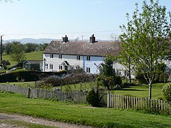
 Cottages by St. Mary's Church, Whitchurch | |
| Location | |
| Grid reference: | SP224485 |
| Location: | 52°8’6"N, 1°40’26"W |
| Data | |
| Postcode: | CV37 |
| Local Government | |
| Council: | Stratford-on-Avon |
Whitchurch is a small hamlet on the left bank of the River Stour in southern Warwickshire, some four miles south of the famed town of Stratford-upon-Avon. The church, St Mary's, stands in the meadows by the Stour opposite Alderminster, with a single footpath leading away to the one farm on the lane, Whitchurch Farm.
The parish population at the 2011 census was 174.
Consisting today of just five properties with a total population (in 2007) of 19, Whitchurch occupies the site of an earlier, larger village which was depopulated in the 15th and 16th centuries as the result of land clearance schemes carried out by the then lords of the manor.[1] A Norman church survives, now standing alone in the middle of fields, and the mediæval village's fish ponds are still visible today when the river floods.
In this southern part of Warwickshire, the county borders are somewhat complex, and while the parish is indeed within Warwickshire, then if the detached parts are taken into account it is within a bubble (along with the larger settlements of Wimpstone and Crimscote, Ilmington and Stretton-on-Fosse), separated from the main body of the shire by an exclave of Worcestershire.
John Marius Wilson's Imperial Gazetteer of England and Wales described the parish in 1870-72 thus:
WHITCHURCH, a parish in Stratford-on-Avon district, Warwick; 4 miles SE of Milcote r. station, and 5¼ SSE of Stratford. Post town, Stratford-on-Avon. Acres, 1,942. Real property, £3,971. Pop., 234. Houses, 50. The manor belongs to J. R. West, Esq. The living is a rectory in the diocese of Worcester. Value, £287.* Patron, J. R. West, Esq. Charities, £8"[2]
References
- ↑ British History on-Line: A History of the County of Warwick - Volume 5 : {{{2}}} (Victoria County History)
- ↑ Wilson, John Marius: Imperial Gazetteer of England and Wales (A. Fullerton & Co., 1870) In A Vision of Britain"