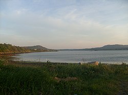
Mulroy Bay: Difference between revisions
Created page with 'right|thumb|350px|Mulroy Bay right|thumb|250px|Mulroy Bay {{county|Donegal}} '''Mulroy Bay''…' |
No edit summary |
||
| Line 18: | Line 18: | ||
The islands were bought from their respective private owners by [[An Taisce]] in order to preserve them and for environmental purposes: the trust believes that the islands could be used as barometers for the environmental health of Mulroy Bay and as a basis for an Integrated Coastal Zone Management Plan. It indents also to have the islands as demonstration models of reversion to natural state.demonstrate coastal management techniques. | The islands were bought from their respective private owners by [[An Taisce]] in order to preserve them and for environmental purposes: the trust believes that the islands could be used as barometers for the environmental health of Mulroy Bay and as a basis for an Integrated Coastal Zone Management Plan. It indents also to have the islands as demonstration models of reversion to natural state.demonstrate coastal management techniques. | ||
==Outside links== | ==Outside links== | ||
*Location map: {{wmap|55.11667|-7.7|zoom=12}} | |||
*[http://www.ecoserve.ie/biomar/mulroy.html Mulroy Bay on ''Ecoserve.ie] | *[http://www.ecoserve.ie/biomar/mulroy.html Mulroy Bay on ''Ecoserve.ie] | ||
| Line 27: | Line 26: | ||
{{reflist}} | {{reflist}} | ||
Mulroy Bay has extensive Fish and Shellfish farming operations. Mussels, Scallops and Salmon are grown on a commercial basis. | Mulroy Bay has extensive Fish and Shellfish farming operations. Mussels, Scallops and Salmon are grown on a commercial basis. | ||
[[Category:Sea loughs of County Donegal]] | [[Category:Sea loughs of County Donegal]] | ||
Latest revision as of 14:01, 20 November 2018


Mulroy Bay is a relatively small bay in the form of a sea loch slicing into the north coast of County Donegal westward of Lough Swilly.
Mulroy Bay is the most convoluted of the marine inlets in Donegal's Atlantic-battered coast. It is approximately 7½ miles long in a north-south direction. The entrance to the bay is a narrow embayment leading to a winding entrance channel 6 miles in length. This channel cuts south into the land varying in width and depth, with three significant narrows only 150 yards across, where the current reaches maxima of 3-5 knots.
The lough opens into the Broad Water, an open shallow sea lough 5 miles from north to south and a mile and half from east to west, generally less than 11 fathoms in depth and with many small rocky islands and islets.[1][2] The lough reaches east at the Broad Water above which two arms of the lough branch out northwards and southwards, the southern brach reaching a lough head near Milford.
Villages on the shores of the bay include Milford, Kerrykeel and Cranford.
Rough Island and the Gull Islands
The C19223022 are situated close to the western coastline, equidistant to the town of Milford and the village of Cranford. C19973055 is on the eastern coastline on a latitude just north of the Gull Islands. All are small and uninhabited.
Rough Island is a drumlin; one of only two in Mulroy Bay. It has evidence of human settlement.
The Gull Islands are so called because they form a breeding ground for gulls, herring gulls in particular.
The islands were bought from their respective private owners by An Taisce in order to preserve them and for environmental purposes: the trust believes that the islands could be used as barometers for the environmental health of Mulroy Bay and as a basis for an Integrated Coastal Zone Management Plan. It indents also to have the islands as demonstration models of reversion to natural state.demonstrate coastal management techniques.
Outside links
- Location map: 55°7’0"N, 7°42’0"W
- Mulroy Bay on Ecoserve.ie
References
- ↑ "Donegal". libraryireland.com. http://www.libraryireland.com/Atlas/Donegal.php. Retrieved 13 January 2014.
- ↑ RPS Group News November 2007
Mulroy Bay has extensive Fish and Shellfish farming operations. Mussels, Scallops and Salmon are grown on a commercial basis.