Haddington: Difference between revisions
Created page with '{{Infobox town |name=Haddington |scots=Hadentoun |county=East Lothian |picture=Haddington.jpg |picture caption=Haddington |latitude=55.955621 |longitude=-2.778815 |population =8,…' |
No edit summary |
||
| (3 intermediate revisions by 2 users not shown) | |||
| Line 15: | Line 15: | ||
|constituency=East Lothian | |constituency=East Lothian | ||
}} | }} | ||
The Royal Burgh of '''Haddington''' is the county | The Royal Burgh of '''Haddington''' is the county town of [[East Lothian]], a county also named Haddingtonshire. It stands approximately 20 miles east of [[Edinburgh]]. | ||
Haddington is a small town with a population of less than 9,000, although at one time it was the fourth largest | Haddington is a small town with a population of less than 9,000, although at one time it was the fourth largest in Scotland, after [[Aberdeen]], [[Roxburgh]] and Edinburgh. At the centre of the town is the Town House, originally built in 1748 according to a plan by William Adam. When first built, it consisted of a council chamber, jail and sheriff court, to which assembly rooms were added in 1788, and a new clock in 1835. Nearby is the Corn Exchange (1854) and the County Courthouse (1833). Other notable sites include the Jane Welsh Carlyle House, and Mitchell's Close. | ||
==History== | ==History== | ||
Haddington is an old town. Its name is derived from the Old English ''Hæddingatun'' (town of Hædda's kin") and it appears to have been an English town from the early Anglo-Saxon period. When the Norse destroyed the Kingdom of Northumbria, East Lothian remained in Lothian, the English land outside Norwegian control, but in the later tenth of early eleventh century, Lothian was ceded to the King of Scots. | Haddington is an old town. Its name is derived from the Old English ''Hæddingatun'' (town of Hædda's kin") and it appears to have been an English town from the early Anglo-Saxon period. When the Norse destroyed the Kingdom of Northumbria, East Lothian remained in [[Lothian]], the English land outside Norwegian control, but in the later tenth of early eleventh century, Lothian was ceded to the King of Scots. | ||
Haddington received the | Haddington received the status of a burgh during the reign of King David I (1124–1153); one of the first Scottish burghs,<ref>Book {{cite book | ||
|last =Gray | |last =Gray | ||
|first =W. Forbes | |first =W. Forbes | ||
| Line 61: | Line 61: | ||
==Parish kirk== | ==Parish kirk== | ||
[[File:Haddington st marys church.jpg|thumb|St Mary's Collegiate Church, Haddington]] | [[File:Haddington st marys church.jpg|thumb|St Mary's Collegiate Church, Haddington]] | ||
The Parish Church of St Mary's is today part of the [[Church of Scotland]], but includes an | The Parish Church of St Mary's is today part of the [[Church of Scotland]], but includes an Episcopalian chapel, the ''Lauderdale Aisle'', containing the mausoleum of the Earls of Lauderdale. It is the longest parish church in Scotland and is in regular use for worship and musical events. It is directly adjacent to the river Tyne, beside the 12th century Nungate bridge. | ||
The present building (built with red sandstone from nearby [[Garvald]]) was started in 1375 (an earlier St Mary's Church having been destroyed by the English in 1356), and consecrated in 1410, despite building work not being finished until 1487. The church was partially destroyed during the 1548-49 Siege of Haddington that followed the Rough Wooing of Henry VIII, and on the advice of John Knox, it was restored "frae the tower to the West door". Thus the nave became the church and the choir and transepts were left ruined until the whole church was restored in the 1970s. | The present building (built with red sandstone from nearby [[Garvald]]) was started in 1375 (an earlier St Mary's Church having been destroyed by the English in 1356), and consecrated in 1410, despite building work not being finished until 1487. The church was partially destroyed during the 1548-49 Siege of Haddington that followed the Rough Wooing of Henry VIII, and on the advice of John Knox, it was restored "frae the tower to the West door". Thus the nave became the church and the choir and transepts were left ruined until the whole church was restored in the 1970s. | ||
| Line 68: | Line 68: | ||
==Economy== | ==Economy== | ||
Haddington is located predominantly on the north-east bank of the [[River Tyne, East Lothian|River Tyne]], and was once famous for its mills. It developed into the fourth largest town in Scotland during the | Haddington is located predominantly on the north-east bank of the [[River Tyne, East Lothian|River Tyne]], and was once famous for its mills. It developed into the fourth largest town in Scotland during the High Middle Ages, and latterly was at the centre of the mid-18th century Agricultural Revolution. | ||
In 1641 an Act was passed by Parliament to encourage the production of fine cloth, and in 1645 an amendment went through stating that the masters and workers of manufactories would be exempt from military service. As a result of this, more factories were established; these included the New Mills. This factory suffered during the Wars of the Three Kingdoms, with the loss of its cloth to General Monck. A new charter was drawn up in May 1681, and major capital invested in new machinery, but the New Mills had mixed fortunes, inevitably affected by the lack of protectionism for Scottish manufactured cloth. The ''Scots Courant'' reported in 1712 that New Mills was to be 'rouped' (auctioned). The property was sold on 16 February 1713 and the machinery and plant on March 20. The lands of New Mills were purchased by Colonel Francis Charteris and he changed their name to Amisfield. | In 1641 an Act was passed by Parliament to encourage the production of fine cloth, and in 1645 an amendment went through stating that the masters and workers of manufactories would be exempt from military service. As a result of this, more factories were established; these included the New Mills. This factory suffered during the Wars of the Three Kingdoms, with the loss of its cloth to General Monck. A new charter was drawn up in May 1681, and major capital invested in new machinery, but the New Mills had mixed fortunes, inevitably affected by the lack of protectionism for Scottish manufactured cloth. The ''Scots Courant'' reported in 1712 that New Mills was to be 'rouped' (auctioned). The property was sold on 16 February 1713 and the machinery and plant on March 20. The lands of New Mills were purchased by Colonel Francis Charteris and he changed their name to Amisfield. | ||
As the county town of East Lothian Haddington has long been the seat of administrative offices | As the county town of East Lothian, Haddington has long been the seat of administrative offices, which are an important part of the town's economy. The current council's offices are in a building which occupy the site of Haddington's 12th-century royal palace and adjoins the sheriff court complex. | ||
The town now has a range of retail shops, chain stores and others and retains its industrial capacity in the works beside the Tyne at the Victoria Bridge, and around the site of the old station, where are found industrial units and garages. | The town now has a range of retail shops, chain stores and others and retains its industrial capacity in the works beside the Tyne at the Victoria Bridge, and around the site of the old station, where are found industrial units and garages. | ||
A farmers is | A farmers' market is held on the last Saturday of the month in Court Street. | ||
==Sights about the town== | ==Sights about the town== | ||
[[File:Haddington nungate bridge.jpg|thumb | [[File:Haddington nungate bridge.jpg|thumb|Nungate Bridge, Haddington]] | ||
Amisfield House was located east of Haddington, south of the River Tyne. Designed by architect Isaac Ware<ref>''The Country Houses, Castles and Mansions of East Lothian,'' by Sonia Baker ISBN 9781840334579</ref> and built of Garvald red freestone, it was described in ''The Buildings of Scotland'' as "the most important building of the orthodox | Amisfield House was located east of Haddington, south of the River Tyne. Designed by architect Isaac Ware<ref>''The Country Houses, Castles and Mansions of East Lothian,'' by Sonia Baker ISBN 9781840334579</ref> and built of Garvald red freestone, it was described in ''The Buildings of Scotland'' as "the most important building of the orthodox Palladian school in Scotland." John Henderson built the walled garden in 1783, and the castellated stable block in 1785. The park in front of the house, possibly landscaped by James Bowie, is today entirely ploughed. A victim of dry rot, the house was demolished in 1928. | ||
All that remains of Amisfield today are the summer house, walled garden, ice house, chapel, and gates. | All that remains of Amisfield today are the summer house, walled garden, ice house, chapel, and gates. | ||
[[Lennoxlove House]], a historic 13th century house and estate, lies half a mile south of Haddington. Built by the Giffards of [[Yester Castle|Yester]], it was originally named '''Lethington'''. It was once home to the Maitland family, notably Sir | [[Lennoxlove House]], a historic 13th-century house and estate, lies half a mile south of Haddington. Built by the Giffards of [[Yester Castle|Yester]], it was originally named '''Lethington'''. It was once home to the Maitland family, notably Sir Richard Maitland, and his son William Maitlin, Secretary of State to Mary, Queen of Scots'. The Maitlands left Lennoxlove in the 17th century, and it is now the seat of the Duke of Hamilton and Brandon. | ||
The world's earliest surviving records of a lodge of the Order of Free Gardeners come from Haddington, in 1676.<ref>Article [http://www.historyshelf.org/shelf/free/02.php Origins of Gardener Societies] at historyshelf.org. (accessed 18 March 2007)</ref> | The world's earliest surviving records of a lodge of the Order of Free Gardeners come from Haddington, in 1676.<ref>Article [http://www.historyshelf.org/shelf/free/02.php Origins of Gardener Societies] at historyshelf.org. (accessed 18 March 2007)</ref> | ||
Latest revision as of 14:04, 2 August 2018
| Haddington Scots: Hadentoun | |
| East Lothian | |
|---|---|
 Haddington | |
| Location | |
| Grid reference: | NT511739 |
| Location: | 55°57’20"N, 2°46’44"W |
| Data | |
| Population: | 8,844 |
| Post town: | Haddington |
| Postcode: | EH41 |
| Dialling code: | 01620 |
| Local Government | |
| Council: | East Lothian |
| Parliamentary constituency: |
East Lothian |
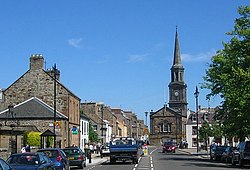
The Royal Burgh of Haddington is the county town of East Lothian, a county also named Haddingtonshire. It stands approximately 20 miles east of Edinburgh.
Haddington is a small town with a population of less than 9,000, although at one time it was the fourth largest in Scotland, after Aberdeen, Roxburgh and Edinburgh. At the centre of the town is the Town House, originally built in 1748 according to a plan by William Adam. When first built, it consisted of a council chamber, jail and sheriff court, to which assembly rooms were added in 1788, and a new clock in 1835. Nearby is the Corn Exchange (1854) and the County Courthouse (1833). Other notable sites include the Jane Welsh Carlyle House, and Mitchell's Close.
History
Haddington is an old town. Its name is derived from the Old English Hæddingatun (town of Hædda's kin") and it appears to have been an English town from the early Anglo-Saxon period. When the Norse destroyed the Kingdom of Northumbria, East Lothian remained in Lothian, the English land outside Norwegian control, but in the later tenth of early eleventh century, Lothian was ceded to the King of Scots.
Haddington received the status of a burgh during the reign of King David I (1124–1153); one of the first Scottish burghs,[1] giving it trading rights which encouraged its growth into a market town. It was also in David I's reign that the name of Haddingtonshire is first seen. The Kings had a palace at Haddington until the town was burnt down in 1216.
Timeline
- Before 1139 - Haddington granted burgh charters, transferred to Ada de Warenne, as a marriage portion, by her father-in-law David I in that year.
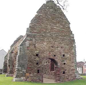
- 1178 – Cistercian abbey founded by Countess Ada. St Martin's Kirk in the Nungate built around or before this year; the oldest standing building in Haddington today.
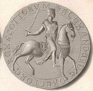
- 1198 – King Alexander II of Scotland is born in Haddington
- 1216 – Haddington is burnt by the English under King John. Scottish royal family vacate the Palace of Haddington.
- 1282 – First mention of a bridge spanning the Tyne.
- 1358 – Flood reportedly washes away the Nungate.
- 1375 – Work begins on rebuilding St Mary's – in Garvald red sandstone.
- 1429 – King's Wall surrounding town is mentioned (which implies early fortification of the town).
- 1462 – Work on the building of St Mary's Church is completed.
- 1548 – 7 July – Signing of the Treaty of Haddington. This was a treaty made during the English occupation of the town. The Scottish Parliament convened in the Abbey and agreed to transport Mary Queen of Scots to France for her marriage to the French heir.[2]
- 1676 – The 'Ancient Fraternity of Gardeners of East Lothian' is established – the oldest such fraternity known.
- 1688 – Rev. John Gray founds a town library.
- 1748 – Haddington's new Town Hall is built; to a design of William Adam
- 1770 – Episcopalian Church built in Church Street.
- 1775 – 4 October – Tyne reportedly rises seventeen feet above its ordinary level.
- 1817 – Building of the Waterloo Bridge near the Poldrate Mill. The foundation stone was laid on the anniversary of the Battle of Waterloo, hence the naming of the bridge.
- 1830 – Spire added to the tower of the Town Hall.
- 1846 – 22 June – Haddington's railway station opens to the public.
- 1854 – Building of the Corn Exchange. This is reputedly the second largest Corn Exchange in Scotland, after Edinburgh.
- 1862 – Roman Catholic church of St Mary is built.
- 1941– 3 March – German bombers damage town.
- 1948 – 6 to 12 August – Flood damages town. Much of the town under water.
- 1949 – 5 December – Closure of Haddington's railway station to the public.
- 1973 – Completion of the re-roofing of the choir & renovation of St Mary's Church. This part of the church was damaged during the siege of Haddington (1547–1549) and left ruinous when the church was restored following the siege.
Parish kirk
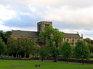
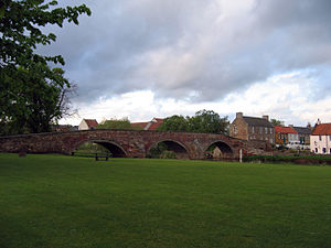
The Parish Church of St Mary's is today part of the Church of Scotland, but includes an Episcopalian chapel, the Lauderdale Aisle, containing the mausoleum of the Earls of Lauderdale. It is the longest parish church in Scotland and is in regular use for worship and musical events. It is directly adjacent to the river Tyne, beside the 12th century Nungate bridge.
The present building (built with red sandstone from nearby Garvald) was started in 1375 (an earlier St Mary's Church having been destroyed by the English in 1356), and consecrated in 1410, despite building work not being finished until 1487. The church was partially destroyed during the 1548-49 Siege of Haddington that followed the Rough Wooing of Henry VIII, and on the advice of John Knox, it was restored "frae the tower to the West door". Thus the nave became the church and the choir and transepts were left ruined until the whole church was restored in the 1970s.
The Lammermuir pipe organ was built in 1990. A set of eight bells hung for full change ringing was installed for the Millennium.
Economy
Haddington is located predominantly on the north-east bank of the River Tyne, and was once famous for its mills. It developed into the fourth largest town in Scotland during the High Middle Ages, and latterly was at the centre of the mid-18th century Agricultural Revolution.
In 1641 an Act was passed by Parliament to encourage the production of fine cloth, and in 1645 an amendment went through stating that the masters and workers of manufactories would be exempt from military service. As a result of this, more factories were established; these included the New Mills. This factory suffered during the Wars of the Three Kingdoms, with the loss of its cloth to General Monck. A new charter was drawn up in May 1681, and major capital invested in new machinery, but the New Mills had mixed fortunes, inevitably affected by the lack of protectionism for Scottish manufactured cloth. The Scots Courant reported in 1712 that New Mills was to be 'rouped' (auctioned). The property was sold on 16 February 1713 and the machinery and plant on March 20. The lands of New Mills were purchased by Colonel Francis Charteris and he changed their name to Amisfield.
As the county town of East Lothian, Haddington has long been the seat of administrative offices, which are an important part of the town's economy. The current council's offices are in a building which occupy the site of Haddington's 12th-century royal palace and adjoins the sheriff court complex.
The town now has a range of retail shops, chain stores and others and retains its industrial capacity in the works beside the Tyne at the Victoria Bridge, and around the site of the old station, where are found industrial units and garages.
A farmers' market is held on the last Saturday of the month in Court Street.
Sights about the town
Amisfield House was located east of Haddington, south of the River Tyne. Designed by architect Isaac Ware[3] and built of Garvald red freestone, it was described in The Buildings of Scotland as "the most important building of the orthodox Palladian school in Scotland." John Henderson built the walled garden in 1783, and the castellated stable block in 1785. The park in front of the house, possibly landscaped by James Bowie, is today entirely ploughed. A victim of dry rot, the house was demolished in 1928.
All that remains of Amisfield today are the summer house, walled garden, ice house, chapel, and gates.
Lennoxlove House, a historic 13th-century house and estate, lies half a mile south of Haddington. Built by the Giffards of Yester, it was originally named Lethington. It was once home to the Maitland family, notably Sir Richard Maitland, and his son William Maitlin, Secretary of State to Mary, Queen of Scots'. The Maitlands left Lennoxlove in the 17th century, and it is now the seat of the Duke of Hamilton and Brandon.
The world's earliest surviving records of a lodge of the Order of Free Gardeners come from Haddington, in 1676.[4]
Picture Gallery
-
Lady Kitty's Doocot
-
The Nungate Bridge
-
High Street, Haddington
References
Notes
- ↑ Book Gray, W. Forbes (1944). A Short History of Haddington. East Lothian Antiquarian and Field Naturalist's Society. p. 1. ISBN 0907590543.
- ↑ Donaldson, Gordon, A Source Book of Scottish History, vol. 2, Thomas Nelson (1953), 135-6, from Acts of the Parliaments of Scotland, vol. 2, (1814), 481-2.
- ↑ The Country Houses, Castles and Mansions of East Lothian, by Sonia Baker ISBN 9781840334579
- ↑ Article Origins of Gardener Societies at historyshelf.org. (accessed 18 March 2007)
Bibliography
- The Records of a Scottish Cloth Manufactory at New Mills, Haddingtonshire edited by W.R.Scott, M.A., Scottish History Society, Edinburgh, 1905.
- The Register of the Privy Council of Scotland, Third Series, edited by P.Hume Brown, M.A.,LL.D., volume V, Edinburgh, 1912, p. 381.
- Lost Houses of Scotland, by M.Binney, J.Harris, & E.Winnington, for 'Save Britain's Heritage', London, July 1980. ISBN 0-905978-05-6
- Haddington: Royal Burgh - A History and a Guide, The Haddington History Society, published 1997 by Tuckwell Press Ltd., ISBN 1-86232-000-4
- The Haddington, Macmerry and Gifford Branch Lines, by Andrew M. Hajducki, Oakwood Press, Oxford, 1994. ISBN 0-85361-456-3
- A Short History of Haddington, by W. Forbes Gray & James H. Jamieson, East Lothian Antiquarian and Field Naturalist's Society, first published 1944, published in a newer edition in 1986 by SPA books, Stevenage. ISBN 0-90759-054-3
- The Country Houses and Mansions of East Lothian by Sonia Baker (2009) ISBN 9781840334579


