Basildon: Difference between revisions
m clean up, typos fixed: re-named → renamed, 1950's → 1950s |
|||
| Line 37: | Line 37: | ||
==Street names== | ==Street names== | ||
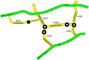
[[File:Mayne roads.jpg|thumb|right|Schematic of 'Mayne' roads]] | [[File:Mayne roads.jpg|thumb|right|Schematic of 'Mayne' roads]] | ||
New streets in Basildon are named with a certain ruthlessness with regard to older names, as all is built anew. Basildon new town has over 1,200 street names and rising. Since the early 1950s, over 200 old street names have been expunged and new names chosen for the new districts | New streets in Basildon are named with a certain ruthlessness with regard to older names, as all is built anew. Basildon new town has over 1,200 street names and rising. Since the early 1950s, over 200 old street names have been expunged and new names chosen for the new districts laid out. Even the new estates cannot escape being changed; in the 1990s, the Crudens estate in Pitsea was renamed "Castle" as it was given a facelift and a revised road layout with new street names. | ||
Some former street names have also been reused in subsequent developments, sometimes with subtle changes, such as the vanished Elizabeth Drive in Laindon which gave a name to Elizabeth Way.<ref>[http://www.basildon.com/history/streets/bsn.html Basildon: Street names]</ref> | Some former street names have also been reused in subsequent developments, sometimes with subtle changes, such as the vanished Elizabeth Drive in Laindon which gave a name to Elizabeth Way.<ref>[http://www.basildon.com/history/streets/bsn.html Basildon: Street names]</ref> | ||
Latest revision as of 15:31, 16 March 2018
| Basildon | |
| Essex | |
|---|---|
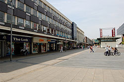
 Basildon Plaza | |
| Location | |
| Grid reference: | TQ735895 |
| Location: | 51°34’34"N, -0°29’19"E |
| Data | |
| Population: | 153,627 (2010 est) |
| Post town: | Basildon |
| Postcode: | SS13 - SS16 |
| Dialling code: | 01268 |
| Local Government | |
| Council: | Basildon |
| Parliamentary constituency: |
Basildon and Billericay South Basildon and East Thurrock |
Basildon is a town in southern Essex, 11 miles south of the county town, Chelmsford and in the strip of towns along the Thames estuary reaching out beyond the metropolis. Nearby towns within this area include Billericay to the north, Wickford northeast, and South Benfleet to the east.
Basildon was designated as a new town in 1948, soon after Second World War, to accommodate the London population overspill,[1] a town created from the conglomeration of four small villages, namely Pitsea, Laindon, Basildon and Vange. The name was taken from the most central of the four villages.
The name 'Basildon' is believed to come from the Old English Beorhtles dun ("Beorhtel's down"). In historical documents, this name had various forms over the centuries, including Berdlesdon, Batlesdon and Belesduna.[2]
History
The first historical reference to Basildon is in records from 1086. It is mentioned in the Domesday Book as 'Belesduna'.[3]
Railway service started in the nineteenth century to Pitsea (1856) and Laindon (1888), which allowed Londoners to flee to the country. By the beginning of the 1900s, Basildon had evolved with much of the land having been sold in small plots during a period of land speculation and development taking placed haphazardly
In the 1920s and 1930s a new social movement looked to the underutilised lands of south Essex as a place to build a new way of life. This, the "plotlands" movement" saw many industrious folk coming out of the overcrowded East End into Basildon and around to acquire small plots, the plotlands, on which they could till the heavy soil and build by hand their own homes out of town. Huts were built, then modest bungalows, built from whatever materials came to hand. Ultimately though the experiment failed to produce the utopia expected and it was brought to an end by the war. The new urban greenbelt too forbade such irregular building.[4]
New Town
In the 1940s, the local councils petitioned the Government to create a New Town, concerned by lack of amenities in the area.[4] Basildon was one of eight 'New Towns' created in the South East of England after the passing of the New Towns Act.[5] The untidy plotlands were targeted as land available for compulsory purchase and development. On 4 January 1949 Lewis Silkin, Minister of Town and Country Planning, officially designated Basildon as a 'New Town'. Basildon Development Corporation was formed in February 1949 to transform the designated area into a modern new town. The New Town incorporated Laindon and Pitsea[5] and was laid out around small neighbourhoods. The first house was completed in June 1951[4] and the first tenants moved into homes in Redgrave Road in Vange.[6]
In March 2010 Basildon paid homage to the infamous white Hollywood sign by creating their own version. At five feet tall, the new sign is one-tenth of the height of the Hollywood original. This is part of a doubtful rejuvenation plan aimed "to bring the town into the 21st Century and to attract more visitors", while many citizens have raised questions about the effectiveness of this spending in a moment where the town is affected by many more urgent social problems.
Street names

New streets in Basildon are named with a certain ruthlessness with regard to older names, as all is built anew. Basildon new town has over 1,200 street names and rising. Since the early 1950s, over 200 old street names have been expunged and new names chosen for the new districts laid out. Even the new estates cannot escape being changed; in the 1990s, the Crudens estate in Pitsea was renamed "Castle" as it was given a facelift and a revised road layout with new street names.
Some former street names have also been reused in subsequent developments, sometimes with subtle changes, such as the vanished Elizabeth Drive in Laindon which gave a name to Elizabeth Way.[7]
Within the town, a number of main road names have included 'mayne' in their name and these are the ones which link the town to and from the A13 and the A127. East Mayne (the A132) runs between the junction of the A127 and the roundabout east of Barstable School. Two of the 'mayne' roads join this roundabout. Broadmayne (the A1321) goes to the town centre. The northerly of the roundabouts at Roundacre and South Mayne (the A132) goes to Pitsea. Nethermayne (the A176) starts at the southerly of the roundabouts at Roundacre and joins the A13 at the Five Bells Roundabout. Also Upper Mayne (the A176) goes from the northerly of the roundabouts at Roundacre and joins the A127 and West Mayne (the B148) runs from a roundabout in Laindon and joins the A127 at Dunton.
Society, leisure and popular culture

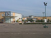
Festival Leisure Park is a trading leisure park located in the north of Basildon. Revamped and renamed as BasVegas it is owned by Aviva.[8] The Festival Leisure Park, includes several restaurants, a bowling and arcade centre, two hotels, a Sixteen screen cinema and two health clubs as well as the third largest nightclub complex in the UK. Locally, the Festival Leisure Park is colloquially known as "Bas Vegas", a well known trouble spot, especially on Friday and Saturday nights, usually fuelled by alcohol. This name which was adopted by the organisation in charge of the new casino development, who used the slogan on signs welcoming people into Basildon by road.
In 1989 the culture and history of the town was documented by the newly re-opened Towngate Theatre, when it commissioned a community play from Arnold Wesker for the town's 40th anniversary. The potted history that Wesker called "Boerthal's Hill" was acted out by some 100 members of the community and portrayed a welcoming haven for visitors. Although it was generally positive in its view of the town, controversy arose where the play touched on the apparent racism of politicians throughout the 1970s.
Modern Architecture
The Town of Basildon currently has many modern Modern Architectural Structures due to the Town's economic growth. Basildon has many 'tall' structures and buildings in comparison to other New Towns that were constructed in the 1950s-1960's. One of Basildon's first tall buildings was 'Brooke House', a tall block of flats situated in the Basildon Town Centre. However, since the incline of trade in the Town Centre, many great business buildings have been constructed in central Basildon. Although there are many tall buildings in Central Basildon, there are also many newly constructed buildings closer to the 'Basildon Enterprise Corridor' situated in North Basildon, these buildings/constructions have gained much fame with the local community and neighboring townsman.
References
- ↑ "Basildon History Online". Basildon.com. 2009-07-16. http://www.basildon.com/history/home.html. Retrieved 2009-08-06.
- ↑ "The History". Basildon. http://www.basildon.com/history/basildon/basildon.html. Retrieved 2009-08-06.
- ↑ "National Archive Summary Record for Basildon". nationalarchives.gov.uk. November 2006. http://www.nationalarchives.gov.uk/documentsonline/details-result.asp?Edoc_Id=7568162&queryType=1&resultcount=1. Retrieved 2006-11-08.
- ↑ 4.0 4.1 4.2 Peers, Deborah (November 2008). "Once upon a time in ... Basildon". Essex Life (Archant): pp. 72–73. http://edition.pagesuite-professional.co.uk/Launch.aspx?referral=other&pnum=&refresh=Qs3051eD1rF8&EID=e2b10cf0-fd31-44b7-837b-a7ba94501771&skip=true. Retrieved 2009-01-24. (Registration required)
- ↑ 5.0 5.1 http://www.basildon.com/history/home.html
- ↑ "A Chronological History 1950 - 1959". Basildon. http://www.basildon.com/history/chronology/19501959.html. Retrieved 2009-08-06.
- ↑ Basildon: Street names
- ↑ "Leisure real estate market makes waves (appeared in Property Week February 1998)". davidlawson.co.uk. November 2006. http://www.davidlawson.co.uk/Files/LEIS_FE8.htm. Retrieved 2006-11-08.
Books
- Basildon Plotlands: The Londoners' Rural Retreat by Deanna Walker (Phillimore)
- Arcadia for All: The Legacy of a Makeshift Landscape by Dennis Hardy and Colin Ward, 1984
Outside links
| ("Wikimedia Commons" has material about Basildon) |
