The Oa: Difference between revisions
Created page with 'thumb|250px|Waterfall at the Mull of Oa '''The Oa''' ({{lang|gd|An Obha}}) is a rocky region in the southwest of Islay, and island of Argyllshi…' |
No edit summary |
||
| (One intermediate revision by one other user not shown) | |||
| Line 1: | Line 1: | ||
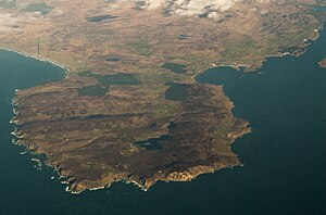
[[File:Mullofoawaterfall.jpg|thumb| | [[File:Mull of Oa, Islay aerial.jpg|right|thumb|300px|The Oa from the air]] | ||
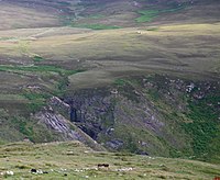
'''The Oa''' | [[File:Mullofoawaterfall.jpg|right|thumb|200px|Waterfall at the Mull of Oa]] | ||
{{county|Argyll}} | |||
'''The Oa''' is a rocky, bulbous headland in the south-west of [[Islay]], in [[Argyllshire]]. Its name is from the Gaelic ''An Obha''. The whole of the Oa is an RSPB nature reserve. | |||
The area is almost an island | The area is almost an island; its high point is [[Beinn Mhòr, Islay|Beinn Mhòr]], rising to 663 feet, in the south. It used to be inhabited, but no longer: in 1830 the parish became deserted due to the Highland Clearances. | ||
==On the Oa== | |||
In 1918, two ships were lost off Islay, the SS ''Tuscania'', a passenger liner, and HMS ''Otranto''.<ref name=islay>[http://www.islayinfo.com/islay_oa_peninsula.html The Oa Peninsula] – 'Guide to the Isle of Islay'</ref> </ref> The American Monument was erected on the south coast by the American Red Cross to commemorate them. | |||
The area around the memorial is | The area around the memorial is a Nature Reserve owned by the Royal Society for the Protection of Birds,<ref>{{rspb|The Oa}}</ref> where chough, golden eagles, corn crakes and sea birds can be seen. 4,772 acres have been designated as a Special Protection Area for the protection of the chough.<ref name=islay/> Ireland]] can be seen from the south peninsula on a clear day.<ref>United Kingdom Ordnance Survey Map, Landranger, 1:50,000 scale</ref> | ||
==Location== | |||
*Location map: {{wmap|55.6166667|-6.2833333|zoom=14}} | |||
==See also== | |||
*[[Ae]] | |||
==Outside links== | |||
{{commons|The Oa, Islay}} | |||
==References== | ==References== | ||
Latest revision as of 13:40, 1 March 2018


The Oa is a rocky, bulbous headland in the south-west of Islay, in Argyllshire. Its name is from the Gaelic An Obha. The whole of the Oa is an RSPB nature reserve.
The area is almost an island; its high point is Beinn Mhòr, rising to 663 feet, in the south. It used to be inhabited, but no longer: in 1830 the parish became deserted due to the Highland Clearances.
On the Oa
In 1918, two ships were lost off Islay, the SS Tuscania, a passenger liner, and HMS Otranto.[1] </ref> The American Monument was erected on the south coast by the American Red Cross to commemorate them.
The area around the memorial is a Nature Reserve owned by the Royal Society for the Protection of Birds,[2] where chough, golden eagles, corn crakes and sea birds can be seen. 4,772 acres have been designated as a Special Protection Area for the protection of the chough.[1] Ireland]] can be seen from the south peninsula on a clear day.[3]
Location
- Location map: 55°37’0"N, 6°16’60"W
See also
Outside links
| ("Wikimedia Commons" has material about The Oa) |
