County Donegal: Difference between revisions
| (4 intermediate revisions by 2 users not shown) | |||
| Line 2: | Line 2: | ||
|name=County Donegal | |name=County Donegal | ||
|irish=Contae Dhún na nGall | |irish=Contae Dhún na nGall | ||
|map image= | |map image=Donegal Ireland (BI Sect 7).svg | ||
|picture=SlieveLeague ToneMapped.jpg | |picture=SlieveLeague ToneMapped.jpg | ||
|picture caption=Slieve League cliffs | |picture caption=Slieve League cliffs | ||
| Line 15: | Line 15: | ||
==Geography== | ==Geography== | ||
In terms of size and area, it is the largest county in Ulster and the fourth largest county in all of Ireland. Uniquely, County Donegal shares a border with only one other county in the Republic of Ireland – [[County Leitrim|Leitrim]]. The greater part of its land border is shared with three counties of Northern Ireland: [[County Londonderry|Londonderry]], [[ | In terms of size and area, it is the largest county in Ulster and the fourth largest county in all of Ireland. Uniquely, County Donegal shares a border with only one other county in the Republic of Ireland – [[County Leitrim|Leitrim]]. The greater part of its land border is shared with three counties of Northern Ireland: [[County Londonderry|Londonderry]], [[Tyrone]] and [[Fermanagh]]. This geographic 'isolation' from the rest of the Republic has led to Donegal people maintaining a distinct cultural identity<ref>{{cite web|url=http://www.donegallibrary.ie/quicklinks/aboutdonegal/ |title=Donegal Library Services |publisher=Donegallibrary.ie |date= |accessdate=9 July 2013}}</ref> and has been used to market the county with the slogan ''Up here it's different''.<ref name = "IE NW">[http://www.irelandnorthwest.ie/?id=28 Ireland Northwest].</ref> While Lifford is the County Town, Letterkenny is by far the largest town in the county with a population of 19,588. Letterkenny and the nearby city of Londonderry form the main economic axis of the north-west of Ireland.<ref>{{cite web|url=http://www.sinnfein.ie/contents/16086 |title=Derry and Donegal Sinn Féin Councillors join forces to push North West tourism |publisher=Sinnfein.ie |date=16 February 2009 |accessdate=9 July 2013}}</ref> | ||
The [[townland]] of Drumlongfield in the parish of Templecarn forms a detached part of the county locally situate in [[Fermanagh]].<ref>Townland of Drumlongfield in the parish of Templecarn: {{wmap|54.562107|-7.80239|zoom=14|base=outline_detached}}</ref> | |||
===Baronies=== | ===Baronies=== | ||
[[File:Co Donegal.jpg|330px|right|thumb|The Poison Glen, in North West Donegal.]] | [[File:Co Donegal.jpg|330px|right|thumb|The Poison Glen, in North West Donegal.]] | ||
There are eight | There are eight baronies in the county: | ||
* Banagh | * Banagh | ||
| Line 38: | Line 40: | ||
! Town !! Population (2011 Census) | ! Town !! Population (2011 Census) | ||
|- | |- | ||
| Letterkenny || 19,588 | | [[Letterkenny]] || 19,588 | ||
|- | |- | ||
| Buncrana || 7,199 | | [[Buncrana]] || 7,199 | ||
|- | |- | ||
| Ballybofey/Stranorlar || 4,852 | | [[Ballybofey]]/[[Stranorlar]] || 4,852 | ||
|- | |- | ||
| Donegal | | [[Donegal]] || 2,607 | ||
|- | |- | ||
| Carndonagh || 2,534 | | [[Carndonagh]] || 2,534 | ||
|- | |- | ||
| Ballyshannon || 2,504 | | [[Ballyshannon]] || 2,504 | ||
|- | |- | ||
| Bundoran || 2,140 | | [[Bundoran]] || 2,140 | ||
|- | |- | ||
| Lifford || 1,658 | | [[Lifford]] || 1,658 | ||
|- | |- | ||
| Bunbeg/Derrybeg || 1,553 | | [[Bunbeg]]/[[Derrybeg]] || 1,553 | ||
|- | |- | ||
| Milford, County Donegal|Milford || 1,530 | | [[Milford, County Donegal|Milford]] || 1,530 | ||
|- | |- | ||
| Moville || 1,481 | | [[Moville]] || 1,481 | ||
|- | |- | ||
| Convoy | | [[Convoy]] || 1,438 | ||
|- | |- | ||
| Killybegs || 1,297 | | [[Killybegs]] || 1,297 | ||
|- | |- | ||
| Muff, County Donegal|Muff || 1,271 | | [[Muff, County Donegal|Muff]] || 1,271 | ||
|- | |- | ||
| Ramelton || 1,212 | | [[Ramelton]] || 1,212 | ||
|- | |- | ||
| Dungloe || 1,183 | | [[Dungloe]] || 1,183 | ||
|- | |- | ||
| Raphoe || 1,157 | | [[Raphoe]] || 1,157 | ||
|- | |- | ||
| Newtowncunningham || 1,067 | | [[Newtowncunningham]] || 1,067 | ||
|} | |} | ||
Latest revision as of 09:27, 19 December 2017
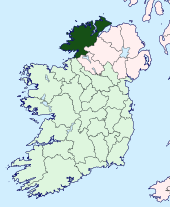
| County Donegal Irish: Contae Dhún na nGall Republic of Ireland | |
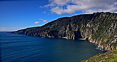 Slieve League cliffs | |
|---|---|
| |
| [Interactive map] | |
| Province: | Ulster |
| Area: | 1,869 square miles |
| Population: | 147,264 |
| County seat: | Lifford |
| Biggest town: | Letterkenny |
The County of Donegal is the northernmost shire of the Republic of Ireland. Located in the province of Ulster in north-west Ireland, it is named after its traditional county town of Donegal, although Lifford serves as the county town. The population of the county was 161,137 according to the 2011 census.
Geography
In terms of size and area, it is the largest county in Ulster and the fourth largest county in all of Ireland. Uniquely, County Donegal shares a border with only one other county in the Republic of Ireland – Leitrim. The greater part of its land border is shared with three counties of Northern Ireland: Londonderry, Tyrone and Fermanagh. This geographic 'isolation' from the rest of the Republic has led to Donegal people maintaining a distinct cultural identity[1] and has been used to market the county with the slogan Up here it's different.[2] While Lifford is the County Town, Letterkenny is by far the largest town in the county with a population of 19,588. Letterkenny and the nearby city of Londonderry form the main economic axis of the north-west of Ireland.[3]
The townland of Drumlongfield in the parish of Templecarn forms a detached part of the county locally situate in Fermanagh.[4]
Baronies

There are eight baronies in the county:
- Banagh
- Boylagh
- Inishowen East
- Inishowen West
- Kilmacrennan
- Raphoe North
- Raphoe South
- Tirhugh
Informal districts
The county may be informally divided into a number of traditional districts. There are two Gaeltacht districts in the west: The Rosses, centred on the town of Dungloe, and Gweedore. Another Gaeltacht district is located in the north-west: Cloughaneely, centred on the town of Falcarragh. The most northerly part of the island of Ireland is the location for three peninsulas of outstanding natural beauty: Inishowen, Fanad and Rosguill. The main population centre of Inishowen, Ireland's largest peninsula, is Buncrana. In the east of the county lies the Finn Valley (centred on Ballybofey). The Laggan district (not to be confused with the more famous Lagan Valley in the south of County Antrim) is centred on the town of Raphoe.

Towns and villages
| Town | Population (2011 Census) |
|---|---|
| Letterkenny | 19,588 |
| Buncrana | 7,199 |
| Ballybofey/Stranorlar | 4,852 |
| Donegal | 2,607 |
| Carndonagh | 2,534 |
| Ballyshannon | 2,504 |
| Bundoran | 2,140 |
| Lifford | 1,658 |
| Bunbeg/Derrybeg | 1,553 |
| Milford | 1,530 |
| Moville | 1,481 |
| Convoy | 1,438 |
| Killybegs | 1,297 |
| Muff | 1,271 |
| Ramelton | 1,212 |
| Dungloe | 1,183 |
| Raphoe | 1,157 |
| Newtowncunningham | 1,067 |
Physical geography

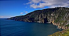

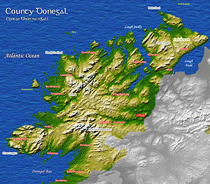
The county is the most mountainous in Ulster consisting chiefly of two ranges of low mountains; the Derryveagh Mountains in the north and the Bluestack Mountains in the south, with Mount Errigal at 2,457 ft the highest peak. It has a deeply indented coastline forming natural sea loughs, of which both Lough Swilly and Lough Foyle are the most notable. The Slieve League cliffs are the sixth-highest sea cliffs in Europe, while Malin Head is the most northerly point on the island of Ireland.
The climate is temperate and dominated by the Gulf Stream, with warm, damp summers and mild wet winters. Two permanently inhabited islands, Arranmore and Tory Island, lie off the coast, along with a large number of islands with only transient inhabitants. Ireland's second longest river, the Erne, enters Donegal Bay near the town of Ballyshannon. The River Erne, along with other Donegal waterways, has been dammed to produce hydroelectric power. The River Foyle separates part of County Donegal from parts of the counties of Londonderry and Tyrone.
Botany
A survey of the macroscopic marine algae of County Donegal was published in 2003.[5] The survey was compiled using the algal records held in the herbaria of the following institutions: the Ulster Museum, Belfast; Trinity College, Dublin; National University of Ireland, Galway, and the Natural History Museum, London.
Zoology
The animals included in the county include Badgers (Meles meles L.)[6]
There are habitats for the rare Corncrake in the county.[7]
History


At various times in its history, it has been known as County Tirconaill, County Tirconnell or County Tyrconnell. The former was used as its official name during 1922–1927.[9] This is in reference to both the old túath of Tír Chonaill and the earldom that succeeded it.
County Donegal is famous for being the home of the once mighty Clann Dálaigh, whose most famous branch were the Clann Ó Domhnaill, better known in English as the O'Donnell Clan. Until around 1600, the O'Donnells were one of Ireland's richest and most powerful Gaelic (native Irish) ruling-families. Within the Province of Ulster only the O'Neill Clan of modern County Tyrone were more powerful. The O'Donnells were Ulster's second most powerful clan or ruling-family from the early 13th-century through to the start of the 17th-century. For several centuries the O'Donnells ruled Tír Chonaill, a Gaelic kingdom in West Ulster that covered almost all of modern County Donegal. The head of the O'Donnell family had the titles An Ó Domhnaill (meaning The O'Donnell in English) and Rí Thír Chonaill (meaning King of Tír Chonaill in English). Based at Donegal Castle in Dún na nGall (modern Donegal Town), the O'Donnell Kings of Tír Chonaill were traditionally inaugurated at Doon Rock near Kilmacrenan. O'Donnell royal or chiefly power was finally ended in what was then the newly created County Donegal in September 1607, following the Flight of the Earls from near Rathmullan. The modern County Arms of Donegal (dating from the early 1970s) was influenced by the design of the old O'Donnell royal arms. The County Arms are the official coat of arms of both County Donegal and Donegal County Council.

The modern County Donegal was shired[10] by order of the English Crown in 1585. The English authorities at Dublin Castle formed the new county by amalgamating the old Kingdom of Tír Chonaill with the old Lordship of Inishowen. However, the English authorities were unable to establish control over Tír Chonaill and Inishowen until after the Battle of Kinsale in 1602. Full control over the new County Donegal was only achieved after the Flight of the Earls in September 1607. The county was one of those 'planted' during the Plantation of Ulster from around 1610 onwards.
County Donegal was one of the worst affected parts of Ulster during the Great Famine of the late 1840s in Ireland. Vast swathes of the county were devastated by this catastrophe, many areas becoming permanently depopulated. Vast numbers of County Donegal's people emigrated at this time, chiefly through Londonderry Port.
The Partition of Ireland in the early 1920s had a massive direct impact on County Donegal. Partition cut the county off, economically and administratively, from Londonderry, which had acted for centuries as the county's main port, transport hub and financial centre. Londonderry, together with west Tyrone, was henceforward in a new, different jurisdiction officially called Northern Ireland. Partition also meant that County Donegal was now almost entirely cut off from the rest of the jurisdiction in which it now found itself, the new dominion called the Irish Free State, which in April 1949 became the Republic of Ireland. Only a few miles of the county is physically connected by land to the rest of the Republic. The existence of a border cutting Donegal off from her natural hinterlands in Londonderry City and West Tyrone greatly exacerbated the economic difficulties of the county after partition. The county's economy is particularly susceptible, just like that of Londonderry City, to the currency fluctuations of the Euro against sterling.

Places of interest

County Donegal is a favoured destination for many travellers. One of the attractions is Glenveagh National Park (formerly part of the Glenveagh Estate), as yet (March 2012) the only official national park anywhere in the Province of Ulster. The park is a 35,000 acre nature reserve with scenery of mountains, raised boglands, lakes and woodlands. At its heart is Glenveagh Castle, a late Victorian 'folly' that was originally built as a summer residence.
The Donegal Gaeltacht (Irish-speaking district) also attracts young people to County Donegal each year during the school summer holidays. The three-week-long summer Gaeltacht courses give young Irish people from other parts of the country a chance to learn the Irish language and traditional Irish cultural traditions that are still prevalent in parts of Donegal. The Donegal Gaeltacht has traditionally been a very popular destination each summer for young people from Northern Ireland. Scuba diving is also very popular with a club being located in Donegal Town.
References
- ↑ "Donegal Library Services". Donegallibrary.ie. http://www.donegallibrary.ie/quicklinks/aboutdonegal/. Retrieved 9 July 2013.
- ↑ Ireland Northwest.
- ↑ "Derry and Donegal Sinn Féin Councillors join forces to push North West tourism". Sinnfein.ie. 16 February 2009. http://www.sinnfein.ie/contents/16086. Retrieved 9 July 2013.
- ↑ Townland of Drumlongfield in the parish of Templecarn: 54°33’44"N, 7°48’9"W
- ↑ Morton, O. 2003. The marine macroalgae of County Donegal, Ireland. Bull. Ir. biogeog. Soc. 27: 3 – 164
- ↑ Sleeman, P.D. et al 2009. The small-bodied Badgers (Meles meles (L.) of Rutland Island, Co. Donegal. Ir. Nat. J. 30: 1 – 6
- ↑ "Crex Crex Corncrake, Priority Species Northern Ireland". http://www.habitas.org.uk/priority/species.asp?item=23.
- ↑ "Dolmen Centre, Kilclooney, Portnoo, Co.Donegal". Dolmencentre.com. http://www.dolmencentre.com/archaeology.html. Retrieved 9 July 2013.
- ↑ Renamed "County Tirconaill" 1922 by resolution of the county council.(Place Name Confusion — Donegal or Tirconaill, The Irish Times, 24 April 1924). After historians and Gaelic scholars pointed out that the historic territory of Tirconaill did not include the whole county, the name Donegal was re-adopted in 1927 (Back to "Donegal", The Irish Times, 22 November 1927).
- ↑ Connolly, S.J., Oxford Companion to Irish History, page 129. Oxford University Press, 2002. ISBN 978-0-19-923483-7
Further reading
- Seán Beattie (2004). Donegal. Sutton: Printing Press. ISBN 0-7509-3825-0.(Ireland in Old Photographs series)
- Morton, O. 2003. The marine macroalgae of County Donegal, Ireland. Bull. Ir. biogeog.soc. 27: 3–164.
- Annals of the Kingdom of Ireland (Annála Ríoghachta Éireann) by the Four Masters, from the earliest period to the year 1616, compiled during the period 1632–36 by Brother Michael O'Clery, translated and edited by John O'Donovan in 1856, and re-published in 1998 by De Burca, Dublin.
- Parks, H.M. 1958. A general survey of the marine algae of Mulroy Bay, Co. Donegal. Ir. Nat. J. 12: 277–83.
- Parks, H.M. 1958. A general survey of the marine algae of Mulroy Bay, Co. Donegal: II Ir. Nat. J. 12: 324–30.
- Brian Lalor (General Editor), The Encyclopaedia of Ireland. Gill & Macmillan, Dublin 2003.
- Jonathan Bardon, A History of Ulster (Paperback Edition). Blackstaff Press, Belfast 2005.
- Willie Nolan, Máiread Dunleavy and Liam Ronayne (Ed.'s), Donegal: History & Society. Geography Publications, Dublin 1995.
- Alistair Rowan, The Buildings of Ireland: North West Ulster (Pevsner Guides). Yale University Press, London 1979.
- Jim MacLaughlin (Editor), Donegal: The Making of a Northern County. Four Courts Press, Dublin 2007.
- John McCavitt, The Flight of the Earls. Gill & Macmillan, Dublin 2005.
- Seán Beattie, Ancient Monuments of Inishowen, North Donegal. Lighthouse Publications, Carndonagh, Inishowen, County Donegal, 1994 & 2009.
- Carole Pollard, Liam McCormick: Seven Donegal Churches. Gandon Editions, Kinsale, County Cork, 2011.
- Lios-seachas o iar Thir Chonaill, A.J. Hughes, Donegal Annual 37, 1985, pp. 27–31.
- Orthographical evidence of developments in Donegal Irish, A.J. Hughes, Eigse 22, 1987, pp. 126–34.
- Rang scoile a teagascadh i dTir Chonaill?, A.J. Hughes, Donegal annual 39, 1987, pp. 99–102
- John Crowley, William J. Smyth and Mike Murphy (Ed.'s), Atlas of the Great Irish Famine. Cork University Press, Cork, 2012.
Outside links
| ("Wikimedia Commons" has material about Donegal County Donegal) |
- Official County Donegal Portal
- County Donegal Gaelscoil stats 2010–11
- Census 2011 – Donegal Gaeltacht stats
- Census 2006 – Irish language stats for the county
- Donegal County Council
- Donegal County.com & Dún-na-nGall.com Bi-lingual County Site
- A site of information
- DylanFest in Moville
- Beatlesfest on the Lough
- On an Irish Jaunting Car through Donegal and Connemara (1902)
This county article is a stub: help to improve Wikishire by building it up.
| Counties of the Republic of Ireland |
|---|
|
Carlow • Cavan • Clare • Cork • Donegal • Dublin • Galway • Kerry • Kildare • Kilkenny • Laois • Leitrim • Limerick • Longford • Louth • Mayo • Meath • Monaghan • Offaly • Roscommon • Sligo • Tipperary • Waterford • Westmeath • Wexford • Wicklow |
