Difference between revisions of "Southend, Argyll"
(Created page with "{{Infobox town |name=Southend |county=Argyll |picture=Dunaverty - geograph.org.uk - 735878.jpg |picture caption=Dunaverty |population=497 |os grid ref=NR6908 |latitude=55.3163...") |
|||
| Line 15: | Line 15: | ||
|constituency=Argyll and Bute | |constituency=Argyll and Bute | ||
}} | }} | ||
| − | '''Southend''' is the main village at the very southern end of the [[Kintyre]] peninsula in [[Argyll]]. It stands | + | '''Southend''' is the main village at the very southern end of the [[Kintyre]] peninsula in [[Argyll]]. It stands eight miles south of [[Campbeltown]], overlooking the [[North Channel]]. The civil parish of Southend comprises the village and the surrounding land, used mainly for farming and forestry. The population of the parish recorded in 2001 was 497. |
| − | The village is close to the southernmost point of Argyll and | + | The village is close to the southernmost point of mainland Argyll, and indeed the parish contains the very southernmost point on the island of [[Sanda]]. Southend village marks the final termination of the B842 road which runs all down the east coast of Kintyre. To the west rises a massive rock hill, the [[Mull of Kintyre]], and to the south is a clear view of the [[County Antrim]] coast. |
==The village and about it== | ==The village and about it== | ||
| Line 24: | Line 24: | ||
The village is also reputed to be the location where Saint Columba first set foot in Scotland. On a rock near the village are two carved human footprints (Petrosomatoglyphs) called ''Columba's Footprints'' where it is claimed he first preached on Scottish soil, after being banished from Ireland. | The village is also reputed to be the location where Saint Columba first set foot in Scotland. On a rock near the village are two carved human footprints (Petrosomatoglyphs) called ''Columba's Footprints'' where it is claimed he first preached on Scottish soil, after being banished from Ireland. | ||
| − | The parish kirk is St Blaan's church. The village has too a primary school, | + | The parish kirk is St Blaan's church. The village has too a primary school, doctor's surgery, village hall, playing field, 18-hole golf course, caravan and camp-site, the Argyll Arms Hotel and the Muneroy shop and tea-room. The main employment sources are farming, forestry and tourism-related business. |
| − | + | Sanda Island lies two miles south-east of Southend, and can be visited on boat trips from Campbeltown. | |
==Outside links== | ==Outside links== | ||
| Line 33: | Line 33: | ||
==References== | ==References== | ||
{{Reflist}} | {{Reflist}} | ||
| + | [[Category:Extreme points of Argyllshire]] | ||
Latest revision as of 13:36, 8 December 2017
| Southend | |
| Argyllshire | |
|---|---|
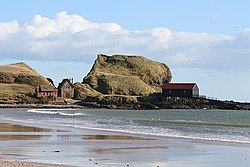
 Dunaverty | |
| Location | |
| Grid reference: | NR6908 |
| Location: | 55°18’59"N, 5°37’59"W |
| Data | |
| Population: | 497 (2001) |
| Post town: | Campbeltown |
| Postcode: | PA28 |
| Dialling code: | 01586 |
| Local Government | |
| Council: | Argyll and Bute |
| Parliamentary constituency: |
Argyll and Bute |
Southend is the main village at the very southern end of the Kintyre peninsula in Argyll. It stands eight miles south of Campbeltown, overlooking the North Channel. The civil parish of Southend comprises the village and the surrounding land, used mainly for farming and forestry. The population of the parish recorded in 2001 was 497.
The village is close to the southernmost point of mainland Argyll, and indeed the parish contains the very southernmost point on the island of Sanda. Southend village marks the final termination of the B842 road which runs all down the east coast of Kintyre. To the west rises a massive rock hill, the Mull of Kintyre, and to the south is a clear view of the County Antrim coast.
The village and about it
The village stands beside Dunaverty Bay, which at one end has a rocky promintory called Dunaverty Rock, where a fort was located. It is reputed that during the Dunaverty Massacre the MacDonalds were burned alive in their stronghold at Dunaverty Castle (the trenches of this can still be seen).
The village is also reputed to be the location where Saint Columba first set foot in Scotland. On a rock near the village are two carved human footprints (Petrosomatoglyphs) called Columba's Footprints where it is claimed he first preached on Scottish soil, after being banished from Ireland.
The parish kirk is St Blaan's church. The village has too a primary school, doctor's surgery, village hall, playing field, 18-hole golf course, caravan and camp-site, the Argyll Arms Hotel and the Muneroy shop and tea-room. The main employment sources are farming, forestry and tourism-related business.
Sanda Island lies two miles south-east of Southend, and can be visited on boat trips from Campbeltown.